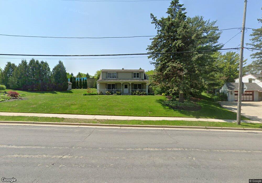
2010 N Main St West Bend, WI 53090
Estimated Value: $334,000 - $388,367
3
Beds
2
Baths
2,136
Sq Ft
$171/Sq Ft
Est. Value
About This Home
This home is located at 2010 N Main St, West Bend, WI 53090 and is currently estimated at $365,842, approximately $171 per square foot. 2010 N Main St is a home located in Washington County with nearby schools including Green Tree Elementary School, Silverbrook Intermediate School, and East High School.
Ownership History
Date
Name
Owned For
Owner Type
Purchase Details
Closed on
Aug 18, 2017
Sold by
Miller Todd M and Miller Lisa R
Bought by
Caretto Jennifer A
Current Estimated Value
Home Financials for this Owner
Home Financials are based on the most recent Mortgage that was taken out on this home.
Original Mortgage
$164,900
Outstanding Balance
$137,596
Interest Rate
3.96%
Mortgage Type
New Conventional
Estimated Equity
$228,246
Create a Home Valuation Report for This Property
The Home Valuation Report is an in-depth analysis detailing your home's value as well as a comparison with similar homes in the area
Home Values in the Area
Average Home Value in this Area
Purchase History
| Date | Buyer | Sale Price | Title Company |
|---|---|---|---|
| Caretto Jennifer A | $170,000 | Access Title Company Inc |
Source: Public Records
Mortgage History
| Date | Status | Borrower | Loan Amount |
|---|---|---|---|
| Open | Caretto Jennifer A | $164,900 |
Source: Public Records
Tax History Compared to Growth
Tax History
| Year | Tax Paid | Tax Assessment Tax Assessment Total Assessment is a certain percentage of the fair market value that is determined by local assessors to be the total taxable value of land and additions on the property. | Land | Improvement |
|---|---|---|---|---|
| 2024 | $3,909 | $304,000 | $54,000 | $250,000 |
| 2023 | $3,478 | $195,600 | $67,800 | $127,800 |
| 2022 | $3,382 | $195,600 | $67,800 | $127,800 |
| 2021 | $3,463 | $195,600 | $67,800 | $127,800 |
| 2020 | $3,420 | $195,600 | $67,800 | $127,800 |
| 2019 | $3,304 | $195,600 | $67,800 | $127,800 |
| 2018 | $3,210 | $195,600 | $67,800 | $127,800 |
| 2017 | $3,882 | $209,800 | $67,800 | $142,000 |
| 2016 | $4,730 | $209,800 | $67,800 | $142,000 |
| 2015 | $6,320 | $209,800 | $67,800 | $142,000 |
| 2014 | $6,320 | $209,800 | $67,800 | $142,000 |
| 2013 | $5,147 | $209,800 | $67,800 | $142,000 |
Source: Public Records
Map
Nearby Homes
- 1900 Camden Ln
- 1817 N Main St
- 7107 River Dr N
- 1669 N Main St
- 1600 Patricia Dr
- 615 Roosevelt Dr
- 1420 W Sunset Ridge Dr
- 2050 Stratford Rd
- Lt3 Woodford Dr
- Lt2 Woodford Dr
- 1509 Monroe St
- 2149 Briar Dr
- Lt1 Sleepy Hollow Rd
- Lt1 Dandelion Ln
- 1348 Fond du Lac St
- 7297 Salisbury Rd
- 1153 N 11th Ave
- 2951 Glen Ivy Dr
- 1521 Quietwood Ln
- 7434 Werner Rd
- 2032 N Main St
- 2009 N Main St
- 2027 N Main St
- 2037 N Main St
- 1950 N Main St
- 812 Fairview Dr
- 1945 Camden Ln
- 1943 Camden Ln
- 2101 Green Tree Rd
- 2101 Green Tree Rd Unit 2101
- 1941 Camden Ln
- 1937 Camden Ln Unit 6104
- 1939 Camden Ln
- 1961 N Main St
- 2055 N Main St
- 813 Fairview Dr
- 1935 Camden Ln
- 808 Fairview Dr
- 1951 Camden Ln
- 2035 Green Tree Rd