


2012 Sunkist Ave Waukesha, WI 53188
Estimated payment $1,856/month
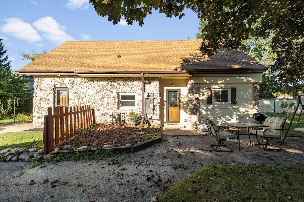
Highlights
- Cape Cod Architecture
- Property is near public transit
- Fenced Yard
- Summit View Elementary School Rated A-
- Main Floor Bedroom
- Stone Flooring
About This Home
Tucked back from the street and framed by a welcoming garden path, this bright and beautifully maintained 3BR, 2BA Cape Cod offers comfort, convenience, and character. Sun-drenched Living Rm and Dinette feature easy-care ceramic tile floorsperfect for everyday living. Kitchen boasts new flooring and refreshed cabinetry, blending functionality with style. Main-floor bedroom with generous closet and updated full bath for added convenience. Upstairs, you'll find a large Master Bedroom with an oversized closet, a 2nd full bath, 3rd bedroom, and a thoughtfully placed laundry area. Recent updates include windows (2007), roof and gutters (2019), and furnace and A/C (2020). Fenced backyard with a large storage shed. And with no basement, you can rest easy knowing water damage won't be a concern.

Home Details
Home Type
- Single Family
Est. Annual Taxes
- $3,130
Lot Details
- 7,841 Sq Ft Lot
- Fenced Yard
Parking
- Driveway
Home Design
- Cape Cod Architecture
- Vinyl Siding
Interior Spaces
- 1,653 Sq Ft Home
- 2-Story Property
- Stone Flooring
- Basement
Kitchen
- Oven
- Range
- Dishwasher
Bedrooms and Bathrooms
- 3 Bedrooms
- Main Floor Bedroom
- 2 Full Bathrooms
Laundry
- Dryer
- Washer
Location
- Property is near public transit
Utilities
- Forced Air Heating and Cooling System
- Heating System Uses Natural Gas
Listing and Financial Details
- Assessor Parcel Number 2910994128
Map
Home Values in the Area
Average Home Value in this Area
Tax History
| Year | Tax Paid | Tax Assessment Tax Assessment Total Assessment is a certain percentage of the fair market value that is determined by local assessors to be the total taxable value of land and additions on the property. | Land | Improvement |
|---|---|---|---|---|
| 2024 | $3,082 | $202,600 | $51,000 | $151,600 |
| 2023 | $3,018 | $202,600 | $51,000 | $151,600 |
| 2022 | $3,100 | $157,000 | $56,100 | $100,900 |
| 2021 | $3,190 | $157,000 | $56,100 | $100,900 |
| 2020 | $3,047 | $157,000 | $56,100 | $100,900 |
| 2019 | $2,807 | $157,000 | $56,100 | $100,900 |
| 2018 | $2,580 | $141,400 | $45,900 | $95,500 |
| 2017 | $2,957 | $141,400 | $45,900 | $95,500 |
| 2016 | $2,676 | $137,300 | $42,800 | $94,500 |
| 2015 | $2,664 | $137,300 | $42,800 | $94,500 |
| 2014 | $3,055 | $130,800 | $42,800 | $88,000 |
| 2013 | $2,641 | $130,800 | $42,800 | $88,000 |
Property History
| Date | Event | Price | List to Sale | Price per Sq Ft |
|---|---|---|---|---|
| 10/26/2025 10/26/25 | Pending | -- | -- | -- |
| 10/10/2025 10/10/25 | For Sale | $302,000 | -- | $183 / Sq Ft |
Purchase History
| Date | Type | Sale Price | Title Company |
|---|---|---|---|
| Warranty Deed | -- | None Available | |
| Interfamily Deed Transfer | -- | -- | |
| Warranty Deed | $111,500 | -- |
Mortgage History
| Date | Status | Loan Amount | Loan Type |
|---|---|---|---|
| Previous Owner | $81,500 | Purchase Money Mortgage |
Source: Metro MLS
MLS Number: 1938815
APN: WAKC-0994-128
Disclaimer: Certain information contained herein is derived from information provided by parties other than Homes.com. All information provided is deemed reliable, but is not guaranteed to be accurate and should be independently verified.
![]() IDX information is provided exclusively for personal, non-commercial use, and may not be used for any purpose other than to identify prospective properties consumers may be interested in purchasing.
IDX information is provided exclusively for personal, non-commercial use, and may not be used for any purpose other than to identify prospective properties consumers may be interested in purchasing.
IDX listing data provided by Multiple Listing Service, Inc. Information is supplied by seller and other third parties and has not been verified.
Copyright 2025 – Multiple Listing Service, Inc. – All Rights Reserved.
- 1516 Pleasant View Ave
- 1810 Patricia Ln
- 2339 Bramblewood Ct
- 1509 Aldoro Dr
- 704 Western Ave
- 1540 Pine St
- 1825 Woodburn Rd Unit C
- 608 N Grandview Blvd
- 2145 Broken Hill Rd Unit 5
- 2207 Norwood Dr
- 2426 Brentwood Dr
- 1952 Garland Ave
- 2013 Woodburn Rd Unit A
- 1400 Summit Ave
- 2112 Woodburn Rd Unit E
- 1505 Elder St
- 2728 Northview Rd Unit 61
- 1508 Delafield St
- 1954 Cascade Dr
- The Adalyn Plan at Tallgrass - Villas