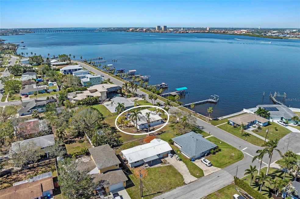
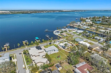
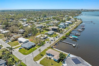
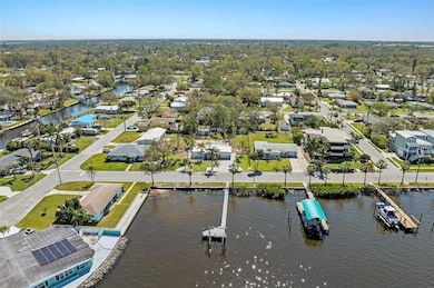
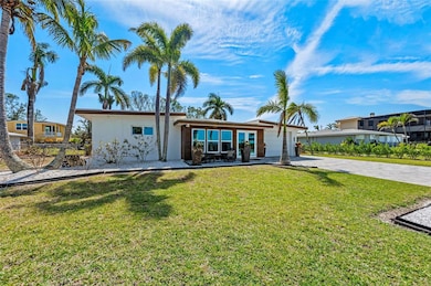
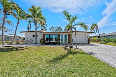
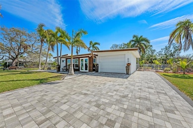
2014 Riverside Dr E Bradenton, FL 34208
Samoset NeighborhoodEstimated payment $5,089/month
Highlights
- Dock has access to electricity and water
- Boat Lift
- 0.44 Acre Lot
- Water access To Gulf or Ocean
- River View
- Open Floorplan
About This Home
Double Waterfront Lot with Direct Manatee River Access - A Truly Rare Riverside Drive Opportunity. Opportunities like this are increasingly rare along Riverside Drive. Set on a one-of-a-kind double waterfront lot, this property delivers direct access to the Manatee River, expansive outdoor space, and the freedom of no HOA restrictions - a combination that is nearly impossible to replicate at this price point. Here, Old Florida charm meets wide-open possibility. Enjoy effortless boating with a straight route to Tampa Bay and the Gulf, plus ample room at home for boats, RVs, trailers, jet skis, work trucks, and every lifestyle toy imaginable, something few waterfront properties can offer. The setting feels private and relaxed, framed by mature trees and the steady rhythm of the river, yet remains just minutes from downtown Bradenton, riverfront dining, marinas, parks, and cultural destinations. The existing home is welcoming, functional, and move-in ready, allowing you to enjoy the waterfront lifestyle immediately. At the same time, the double lot creates an exceptional canvas ideal for expansion, redesign, or building a custom riverfront estate while maintaining privacy, open space, and direct water access. Morning sunrises light the backyard, afternoons invite you onto the water, and evenings settle into breezy golden light that only true riverfront living provides. Riverside Drive is known for its character, authenticity, and sense of place where neighbors value lifestyle over restrictions and waterfront living still feels personal. Whether you envision a peaceful waterfront retreat, a reimagined coastal residence, or a private compound with room to grow, this property offers a rare blend of location, flexibility, and long-term value - especially when compared to nearby vacant waterfront lots priced similarly without a home included. Just minutes to the downtown Bradenton Riverwalk and an easy 11-mile drive to the sugar-sand beaches of Anna Maria Island, this is more than a home, it’s a chance to secure a piece of timeless Florida waterfront, live at your own pace, and invest in a setting that continues to grow more valuable with time. Properties with this combination of land, water access, freedom, and price are seldom available. Schedule your private showing and experience the difference firsthand.
Listing Agent
EXP REALTY LLC Brokerage Phone: 888-883-8509 License #3331706 Listed on: 11/20/2025

Home Details
Home Type
- Single Family
Est. Annual Taxes
- $3,410
Year Built
- Built in 1961
Lot Details
- 19,123 Sq Ft Lot
- North Facing Home
- Property is zoned R1B
Parking
- 1 Car Garage
Home Design
- Slab Foundation
- Membrane Roofing
- Block Exterior
Interior Spaces
- 1,956 Sq Ft Home
- 1-Story Property
- Open Floorplan
- Vaulted Ceiling
- Ceiling Fan
- Family Room Off Kitchen
- Combination Dining and Living Room
- Terrazzo Flooring
- River Views
- Washer and Electric Dryer Hookup
Kitchen
- Range
- Microwave
- Dishwasher
- Stone Countertops
Bedrooms and Bathrooms
- 2 Bedrooms
- 2 Full Bathrooms
Outdoor Features
- Water access To Gulf or Ocean
- River Access
- Boat Lift
- Dock has access to electricity and water
- Exterior Lighting
- Private Mailbox
Utilities
- Central Heating and Cooling System
- Thermostat
Community Details
- No Home Owners Association
- Manatee Gardens Community
- Manatee Gardens Third Sec Subdivision
Listing and Financial Details
- Visit Down Payment Resource Website
- Tax Lot 25
- Assessor Parcel Number 1225500006
Map
Home Values in the Area
Average Home Value in this Area
Tax History
| Year | Tax Paid | Tax Assessment Tax Assessment Total Assessment is a certain percentage of the fair market value that is determined by local assessors to be the total taxable value of land and additions on the property. | Land | Improvement |
|---|---|---|---|---|
| 2025 | $3,410 | $232,656 | -- | -- |
| 2024 | $3,410 | $226,099 | -- | -- |
| 2023 | $3,359 | $219,514 | $0 | $0 |
| 2022 | $3,271 | $213,120 | $0 | $0 |
| 2021 | $3,125 | $206,913 | $0 | $0 |
| 2020 | $3,220 | $204,056 | $0 | $0 |
| 2019 | $3,159 | $199,468 | $0 | $0 |
| 2018 | $3,121 | $195,749 | $0 | $0 |
| 2017 | $2,917 | $191,723 | $0 | $0 |
| 2016 | $2,895 | $187,780 | $0 | $0 |
| 2015 | $2,876 | $184,508 | $0 | $0 |
| 2014 | $2,876 | $183,044 | $0 | $0 |
| 2013 | $2,855 | $180,339 | $0 | $0 |
Property History
| Date | Event | Price | List to Sale | Price per Sq Ft |
|---|---|---|---|---|
| 02/13/2026 02/13/26 | Price Changed | $900,000 | -2.7% | $460 / Sq Ft |
| 11/20/2025 11/20/25 | For Sale | $925,000 | -- | $473 / Sq Ft |
Purchase History
| Date | Type | Sale Price | Title Company |
|---|---|---|---|
| Interfamily Deed Transfer | -- | Attorney | |
| Warranty Deed | $175,000 | -- | |
| Warranty Deed | $134,000 | -- |
Mortgage History
| Date | Status | Loan Amount | Loan Type |
|---|---|---|---|
| Open | $155,000 | No Value Available | |
| Previous Owner | $120,600 | No Value Available |
Source: Stellar MLS
MLS Number: A4672794
APN: 12255-0000-6
Disclaimer: Certain information contained herein is derived from information provided by parties other than Homes.com. All information provided is deemed reliable, but is not guaranteed to be accurate and should be independently verified.
![]() Based on information submitted to the MLS GRID. All data is obtained from various sources and may not have been verified by broker or MLS GRID. Supplied Open House Information is subject to change without notice. All information should be independently reviewed and verified for accuracy. Properties may or may not be listed by the office/agent presenting the information. Some IDX listings have been excluded from this website. IDX information is provided exclusively for personal, non-commercial use, and may not be used for any purpose other than to identify prospective properties consumers may be interested in purchasing. Information is deemed reliable but not guaranteed.
Based on information submitted to the MLS GRID. All data is obtained from various sources and may not have been verified by broker or MLS GRID. Supplied Open House Information is subject to change without notice. All information should be independently reviewed and verified for accuracy. Properties may or may not be listed by the office/agent presenting the information. Some IDX listings have been excluded from this website. IDX information is provided exclusively for personal, non-commercial use, and may not be used for any purpose other than to identify prospective properties consumers may be interested in purchasing. Information is deemed reliable but not guaranteed.
Based on information submitted to the MLS GRID
Listing Information presented by local MLS brokerage: Ten-X - (888)-952-6393
- 210 21st St NE
- 102 20th St NE
- 211 21st St NE
- 1910 Riverside Dr E
- 218 22nd St NE
- 204 22nd Street Ct NE
- 107 22nd St E
- 208 22nd Street Ct NE
- 1906 2nd Ave E
- 1929 3rd Ave E
- 210 22nd Street Ct NE
- 1915 3rd Ave E
- 400 20th St E Unit 1-6
- 1840 3rd Ave E
- 2326 2nd Ave E
- 118 18th St E
- 3907 Goldheart Blvd
- 4034 Goldheart Blvd
- 102 17th St NE
- 1701 Manatee Ave E
- 109 21st St NE
- 2004 2nd Ave E Unit 1
- 1838 1st Ave E
- 1815 2nd Ave E
- 306 19th St E
- 302 19th St E
- 4034 Goldheart Blvd
- 1706 4th Ave E
- 1837 6th Ave E
- 1519 Manatee Ave E
- 2441 6th Avenue Dr E
- 2121 9th Ave E
- 1505 8th Ave E
- 1818 9th Ave E
- 2514 10th Ave Dr E
- 1161 3rd Ave E
- 360 11th St E
- 5200 Riverfront Dr
- 336 Shore Dr
- 908 E Hubbel Rd
Ask me questions while you tour the home.