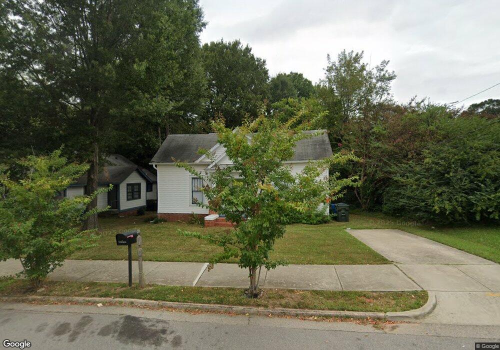
2015 Ashe St Durham, NC 27703
East Durham NeighborhoodEstimated Value: $268,225 - $332,000
3
Beds
1
Bath
1,342
Sq Ft
$223/Sq Ft
Est. Value
About This Home
This home is located at 2015 Ashe St, Durham, NC 27703 and is currently estimated at $299,556, approximately $223 per square foot. 2015 Ashe St is a home located in Durham County with nearby schools including Y E Smith Elementary, W.G. Pearson Elementary School, and Brogden Middle.
Ownership History
Date
Name
Owned For
Owner Type
Purchase Details
Closed on
Aug 20, 2004
Sold by
Federal National Mortgage Association
Bought by
Brickman Brian
Current Estimated Value
Home Financials for this Owner
Home Financials are based on the most recent Mortgage that was taken out on this home.
Original Mortgage
$41,000
Interest Rate
12%
Mortgage Type
Purchase Money Mortgage
Purchase Details
Closed on
Apr 13, 2004
Sold by
Robinson Zadoc
Bought by
Federal National Mortgage Association
Purchase Details
Closed on
Jun 4, 2002
Sold by
Coble Billy R and Coble Linda B
Bought by
Robinson Zadoc
Home Financials for this Owner
Home Financials are based on the most recent Mortgage that was taken out on this home.
Original Mortgage
$49,500
Interest Rate
13%
Create a Home Valuation Report for This Property
The Home Valuation Report is an in-depth analysis detailing your home's value as well as a comparison with similar homes in the area
Home Values in the Area
Average Home Value in this Area
Purchase History
| Date | Buyer | Sale Price | Title Company |
|---|---|---|---|
| Brickman Brian | -- | -- | |
| Federal National Mortgage Association | $62,555 | -- | |
| Robinson Zadoc | $39,000 | -- |
Source: Public Records
Mortgage History
| Date | Status | Borrower | Loan Amount |
|---|---|---|---|
| Closed | Brickman Brian | $41,000 | |
| Previous Owner | Robinson Zadoc | $49,500 |
Source: Public Records
Tax History
| Year | Tax Paid | Tax Assessment Tax Assessment Total Assessment is a certain percentage of the fair market value that is determined by local assessors to be the total taxable value of land and additions on the property. | Land | Improvement |
|---|---|---|---|---|
| 2025 | $2,634 | $265,705 | $101,700 | $164,005 |
| 2024 | $1,139 | $81,627 | $25,425 | $56,202 |
| 2023 | $1,069 | $81,627 | $25,425 | $56,202 |
| 2022 | $1,045 | $81,627 | $25,425 | $56,202 |
| 2021 | $1,040 | $81,627 | $25,425 | $56,202 |
| 2020 | $1,015 | $81,627 | $25,425 | $56,202 |
| 2019 | $1,015 | $81,627 | $25,425 | $56,202 |
| 2018 | $960 | $70,777 | $14,125 | $56,652 |
| 2017 | $953 | $70,777 | $14,125 | $56,652 |
| 2016 | $921 | $70,777 | $14,125 | $56,652 |
| 2015 | $885 | $63,934 | $8,266 | $55,668 |
| 2014 | $846 | $61,111 | $8,266 | $52,845 |
Source: Public Records
Map
Nearby Homes
- 1914 Hart St
- 1902 Angier Ave
- 1900 Angier Ave
- 2065 Bull City Bend Unit 403
- 104 S Driver St
- 101 S Maple St
- 1816 Vale St
- 205 S Briggs Ave
- 1704 E Main St
- 111 N Guthrie Ave
- 2302 Angier Ave
- 101 S Briggs Ave
- 2407 Hart St Unit A
- 506 Bruce St
- 303 Truce St Unit B
- 2318 E Main St
- 2337 E Main St
- 1915 Taylor St
- 618 Troy St
- 600 Bernice St
Your Personal Tour Guide
Ask me questions while you tour the home.