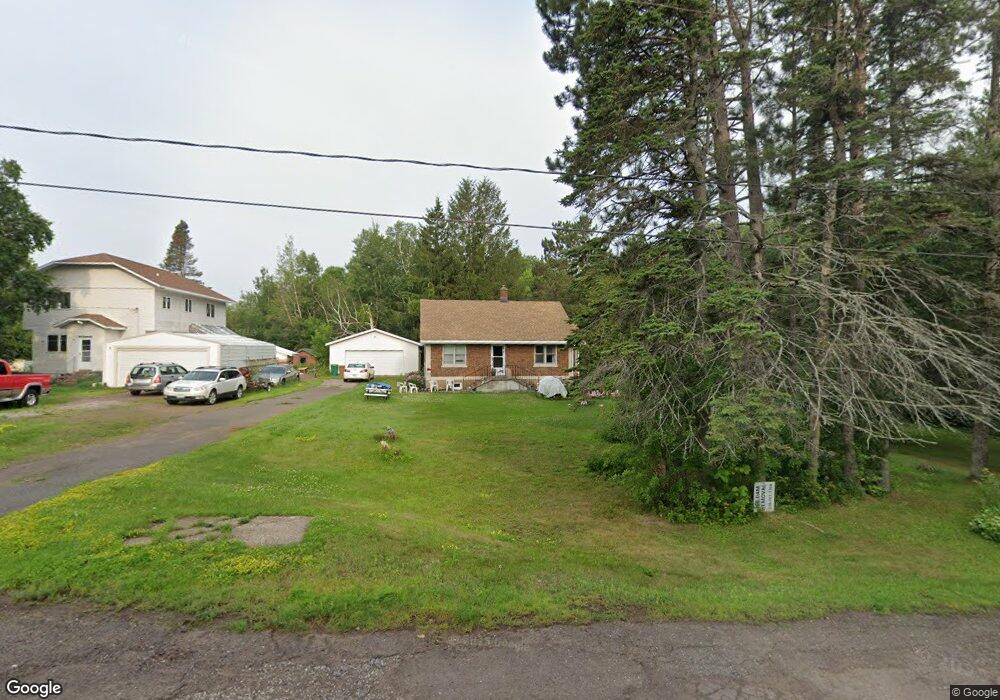
2015 Stanford Ave Duluth, MN 55811
Duluth Heights NeighborhoodEstimated Value: $310,000 - $347,000
4
Beds
2
Baths
1,476
Sq Ft
$221/Sq Ft
Est. Value
About This Home
This home is located at 2015 Stanford Ave, Duluth, MN 55811 and is currently estimated at $326,552, approximately $221 per square foot. 2015 Stanford Ave is a home located in St. Louis County with nearby schools including Lowell Elementary School, Lincoln Park Middle School, and Denfeld High School.
Ownership History
Date
Name
Owned For
Owner Type
Purchase Details
Closed on
Mar 17, 2017
Sold by
Rossetti Patricia J
Bought by
Rossetti Patricia J and The Trust Agreement Of Patricia J Rosset
Current Estimated Value
Purchase Details
Closed on
Jul 10, 2002
Sold by
Lyons Susan C and Lyons Larry R
Bought by
Rossetti Patricia J
Purchase Details
Closed on
Jul 1, 2002
Sold by
Buczek Barbara L and Buczek John
Bought by
Rossetti Patricia J
Create a Home Valuation Report for This Property
The Home Valuation Report is an in-depth analysis detailing your home's value as well as a comparison with similar homes in the area
Home Values in the Area
Average Home Value in this Area
Purchase History
| Date | Buyer | Sale Price | Title Company |
|---|---|---|---|
| Rossetti Patricia J | -- | None Available | |
| Rossetti Patricia J | $32,000 | -- | |
| Rossetti Patricia J | $32,000 | -- |
Source: Public Records
Tax History
| Year | Tax Paid | Tax Assessment Tax Assessment Total Assessment is a certain percentage of the fair market value that is determined by local assessors to be the total taxable value of land and additions on the property. | Land | Improvement |
|---|---|---|---|---|
| 2024 | $3,508 | $274,500 | $65,800 | $208,700 |
| 2023 | $3,508 | $291,200 | $72,400 | $218,800 |
| 2022 | $3,700 | $252,700 | $63,300 | $189,400 |
| 2021 | $3,194 | $237,900 | $58,500 | $179,400 |
| 2020 | $2,928 | $213,000 | $42,800 | $170,200 |
| 2019 | $2,710 | $193,000 | $38,500 | $154,500 |
| 2018 | $2,530 | $181,900 | $38,500 | $143,400 |
| 2017 | $2,486 | $182,100 | $38,700 | $143,400 |
| 2016 | $1,804 | $2,800 | $2,800 | $0 |
| 2015 | $1,836 | $116,200 | $34,400 | $81,800 |
| 2014 | $1,836 | $116,200 | $34,400 | $81,800 |
Source: Public Records
Map
Nearby Homes
- 20xx Stanford Ave
- 1910 Ponderosa Ave
- 35 W Ideal St
- 29 W Ideal St
- 817 Maple Bend Dr
- 205 Bluff's Ridge Ct
- 1145 Como Ave Unit 1
- 4016 W Arrowhead Rd
- 313 W Mulberry St
- 1804 Rice Lake Rd
- 2360 Apple Ridge Dr
- 1944 Chinook Dr
- 1802 Rice Lake Rd
- 1611 Maple Grove Rd
- 1633 Maple Grove Rd
- 14 Deer Valley Rd
- 1950 Middle Ln
- 1524 W Arrowhead Rd
- 2108 Cottage Hill Cir
- 3969 Haines Rd
- 2003 Stanford Ave
- 2002 Stanford Ave
- 148 W Morgan St
- 165 W Morgan St
- 154 W Morgan St
- 160 W Morgan St
- 1920 Stanford Ave
- 201 W Morgan St
- 168 W Morgan St
- 2036 Stanford Ave
- 1910 Stanford Ave
- 164 W Marble St
- 144 W Marble St
- 154 W Marble St
- 147 W Rainbow St
- 1905 Stanford Ave
- 153 W Rainbow St
- 207 W Morgan St
- 202 W Marble St
- 202 W Morgan St
Your Personal Tour Guide
Ask me questions while you tour the home.