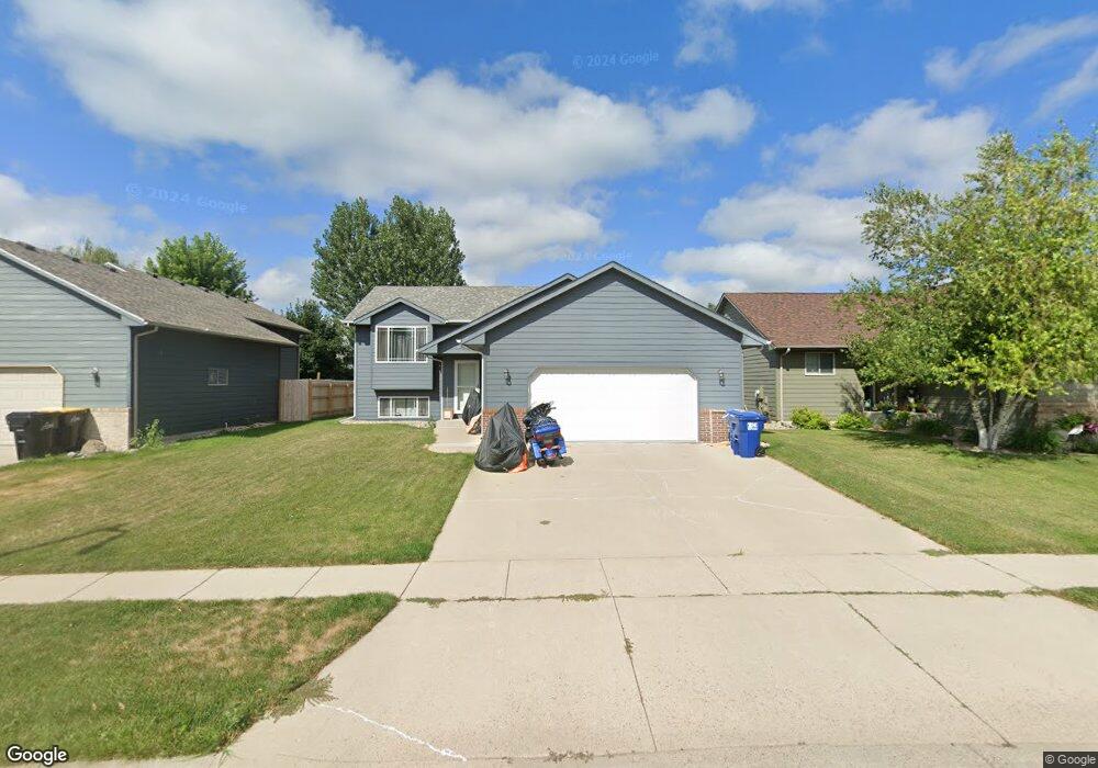
2017 S Mary Beth Ave Sioux Falls, SD 57106
Northwest Sioux Falls NeighborhoodEstimated Value: $333,000 - $375,000
4
Beds
3
Baths
1,883
Sq Ft
$187/Sq Ft
Est. Value
About This Home
This home is located at 2017 S Mary Beth Ave, Sioux Falls, SD 57106 and is currently estimated at $351,718, approximately $186 per square foot. 2017 S Mary Beth Ave is a home located in Minnehaha County with nearby schools including Hayward Elementary School, George McGovern Middle School, and Jefferson High School - 67.
Ownership History
Date
Name
Owned For
Owner Type
Purchase Details
Closed on
May 25, 2023
Sold by
Frock Joshua Adam and Frock Lisa Marie
Bought by
Trusted Warrior Llc
Current Estimated Value
Home Financials for this Owner
Home Financials are based on the most recent Mortgage that was taken out on this home.
Original Mortgage
$199,500
Outstanding Balance
$193,993
Interest Rate
6.43%
Estimated Equity
$157,725
Create a Home Valuation Report for This Property
The Home Valuation Report is an in-depth analysis detailing your home's value as well as a comparison with similar homes in the area
Home Values in the Area
Average Home Value in this Area
Purchase History
| Date | Buyer | Sale Price | Title Company |
|---|---|---|---|
| Trusted Warrior Llc | -- | -- | |
| Trusted Warrior Llc | -- | -- |
Source: Public Records
Mortgage History
| Date | Status | Borrower | Loan Amount |
|---|---|---|---|
| Open | Trusted Warrior Llc | $199,500 | |
| Closed | Trusted Warrior Llc | $199,500 |
Source: Public Records
Tax History
| Year | Tax Paid | Tax Assessment Tax Assessment Total Assessment is a certain percentage of the fair market value that is determined by local assessors to be the total taxable value of land and additions on the property. | Land | Improvement |
|---|---|---|---|---|
| 2024 | $5,225 | $314,800 | $35,300 | $279,500 |
| 2023 | $4,306 | $308,200 | $25,800 | $282,400 |
| 2022 | $4,022 | $271,200 | $25,800 | $245,400 |
| 2021 | $3,330 | $212,800 | $0 | $0 |
| 2020 | $3,330 | $214,800 | $0 | $0 |
| 2019 | $3,164 | $200,268 | $0 | $0 |
| 2018 | $2,886 | $196,056 | $0 | $0 |
| 2017 | $2,742 | $183,345 | $30,360 | $152,985 |
| 2016 | $2,742 | $174,043 | $29,040 | $145,003 |
| 2015 | $2,700 | $164,731 | $29,040 | $135,691 |
| 2014 | -- | $160,740 | $29,040 | $131,700 |
Source: Public Records
Map
Nearby Homes
- 2024 S Shaw Ave
- 2021 S Shaw Ave
- 8708 W Norma Trail
- 0 S Ellis Rd
- 2217 S Ollerich Ave
- 1704 S Andrew Ave
- 1921 S Sonoma Place
- 2037 S Sonoma Pl Place
- 2039 S Sonoma Place
- 2033 S Sonoma Place
- 2045 S Sonoma Place
- 2031 S Sonoma Place
- 2025 S Sonoma Place
- 2043 S Sonoma Pl Place
- 1516 S Kathryn Ave
- 1517 S Kathryn Ave
- 8105 W 24th St
- 8101 W 24th St
- 1508 S Kathryn Ave
- 9238 W Norma Trail
- 2013 S Mary Beth Ave
- 2025 S Mary Beth Ave
- 2009 Mary Beth Ave
- 2009 S Mary Beth Ave
- 2020 S Shaw Ave
- 2016 S Shaw Ave
- 8614 W Grinn Place Unit 24
- 2005 Mary Beth Ave
- 8615 W Grinn Place Unit 20
- 2005 S Mary Beth Ave
- 2012 S Shaw Ave
- 8612 W Grinn Place Unit 23
- 2008 S Shaw Ave
- 8700 W Laverne Wipf St
- 8613 W Grinn Place Unit 19
- 8610 W Grinn Place Unit 22
- 8608 W Grinn Place Unit 21
- 2001 S Mary Beth Ave
- 8609 W Grinn Place Unit 17
- 2028 S Shaw Ave
Your Personal Tour Guide
Ask me questions while you tour the home.