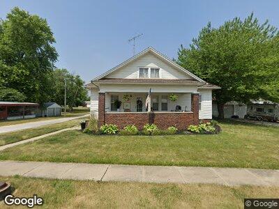
202 N Price St Industry, IL 61440
Estimated Value: $69,000 - $85,000
2
Beds
--
Bath
1,263
Sq Ft
$60/Sq Ft
Est. Value
About This Home
This home is located at 202 N Price St, Industry, IL 61440 and is currently estimated at $76,405, approximately $60 per square foot. 202 N Price St is a home located in McDonough County with nearby schools including Washington Elementary School, Webster Elementary School, and Schuyler Industry Middle School.
Ownership History
Date
Name
Owned For
Owner Type
Purchase Details
Closed on
Jul 15, 2020
Sold by
Cox Drew and Cox Hannah
Bought by
Hendricks Sara Louise
Current Estimated Value
Home Financials for this Owner
Home Financials are based on the most recent Mortgage that was taken out on this home.
Original Mortgage
$50,050
Outstanding Balance
$45,618
Interest Rate
4%
Mortgage Type
Future Advance Clause Open End Mortgage
Estimated Equity
$31,736
Purchase Details
Closed on
Apr 25, 2017
Sold by
Beck Lindell E and Beck Kent L
Bought by
Cox Drew
Home Financials for this Owner
Home Financials are based on the most recent Mortgage that was taken out on this home.
Original Mortgage
$38,000
Interest Rate
4.08%
Mortgage Type
New Conventional
Create a Home Valuation Report for This Property
The Home Valuation Report is an in-depth analysis detailing your home's value as well as a comparison with similar homes in the area
Home Values in the Area
Average Home Value in this Area
Purchase History
| Date | Buyer | Sale Price | Title Company |
|---|---|---|---|
| Hendricks Sara Louise | $58,000 | Attorney | |
| Cox Drew | $40,000 | None Available |
Source: Public Records
Mortgage History
| Date | Status | Borrower | Loan Amount |
|---|---|---|---|
| Open | Hendricks Sara Louise | $50,050 | |
| Previous Owner | Cox Drew | $38,000 |
Source: Public Records
Tax History Compared to Growth
Tax History
| Year | Tax Paid | Tax Assessment Tax Assessment Total Assessment is a certain percentage of the fair market value that is determined by local assessors to be the total taxable value of land and additions on the property. | Land | Improvement |
|---|---|---|---|---|
| 2024 | $1,096 | $20,996 | $2,945 | $18,051 |
| 2023 | $1,096 | $20,996 | $2,945 | $18,051 |
| 2022 | $1,036 | $19,939 | $2,797 | $17,142 |
| 2021 | $1,012 | $19,573 | $2,746 | $16,827 |
| 2020 | $1,044 | $21,906 | $2,695 | $19,211 |
| 2019 | $1,148 | $19,702 | $2,764 | $16,938 |
| 2018 | $1,158 | $20,166 | $2,829 | $17,337 |
| 2017 | $1,648 | $20,166 | $2,829 | $17,337 |
| 2016 | $0 | $19,883 | $2,789 | $17,094 |
| 2015 | -- | $19,643 | $2,755 | $16,888 |
| 2014 | -- | $19,643 | $2,755 | $16,888 |
| 2013 | -- | $18,531 | $2,599 | $15,932 |
Source: Public Records
Map
Nearby Homes
- 00 Hickory School Rd
- 7884 E 1100th St
- 6520 E 875th St
- 11 Marty Ln
- 1295 China Rd
- 1907 S Madison St
- 1313 Grand Ave
- 1400 E Thomas St
- 302 Oak St
- 10845 E 1200th St
- 124 Harmony Ln
- 1308 Meadowlark Ln
- 427 W Main St
- 949 Pennyoaks Dr
- 1009 S Candy Ln
- 1125 Bobby Ave
- 940 Memorial Dr
- 1600 Cherokee Rd
- 849 E Franklin St
- 422 E Grant St
- 202 N Price St
- 204 N Price St
- 206 N Price St
- 106 N Price St
- 202 E Mcgowan St
- 105 N Price St
- 205 E Mcgowan St
- 201 N Sullivan St
- 112 E Main St
- 208 N Price St
- 202 E Main St
- 204 E Mcgowan St
- 108 E Main St
- 205 N Price St
- 207 E Mcgowan St
- 106 E Main St
- 206 E Main St
- 205 N Sullivan St
- 209 E Mcgowan St
- 103 N Sullivan St