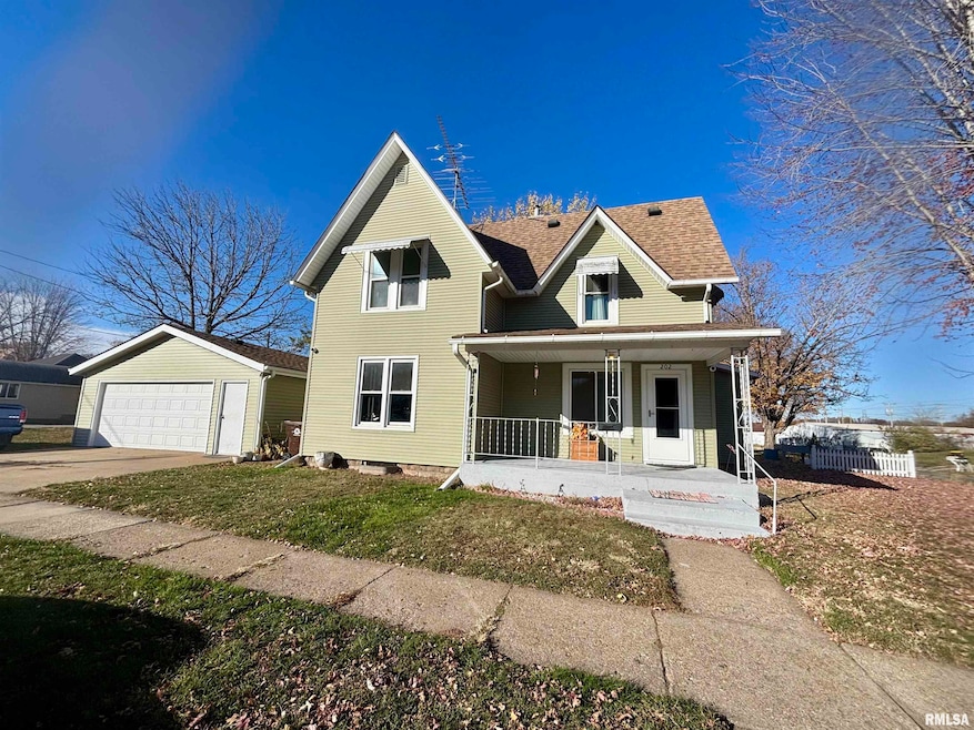
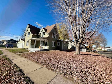
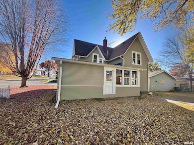

202 W Apple St Maquoketa, IA 52060
Estimated payment $973/month
Highlights
- Corner Lot
- 2 Car Detached Garage
- Forced Air Heating System
- Formal Dining Room
- Enclosed Patio or Porch
- 3-minute walk to Little Bear Park
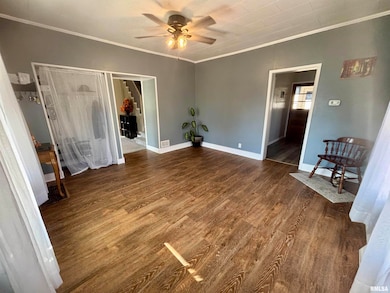
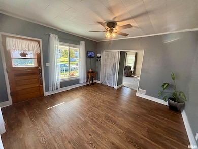
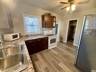
About This Home
Welcome home to this beautifully maintained property situated near parks, an elementary school, and downtown shopping—offering convenience and comfort right at your doorstep. The newly remodeled main floor features fresh paint, new carpet, and stylish vinyl flooring throughout, creating a clean and modern feel. Enjoy not one, but two adorable porches—an open front porch perfect for morning coffee and an enclosed back porch ideal for relaxing in any season. This home boasts numerous updates, including siding, windows, electrical, and a newer water heater, giving you peace of mind for years to come. The unfinished basement is very clean and flexible—use it as a workout area, home office, hobby room, or simply extra storage space. Laundry is also located on the lower level. Car enthusiasts and hobbyists will love the insulated, heated 2-car garage equipped with its own amp box! If you’re looking for a move-in-ready home in a fantastic location with thoughtful updates, this one is a must-see!
Listing Agent
eXp Realty Brokerage Phone: 563-321-0830 License #S71994000 Listed on: 11/06/2025

Home Details
Home Type
- Single Family
Est. Annual Taxes
- $826
Year Built
- Built in 1910
Lot Details
- Lot Dimensions are 120.00x60.00
- Corner Lot
- Level Lot
Parking
- 2 Car Detached Garage
- Heated Garage
- Garage Door Opener
Home Design
- Shingle Roof
- Vinyl Siding
Interior Spaces
- 1,553 Sq Ft Home
- Window Treatments
- Formal Dining Room
- Unfinished Basement
- Basement Fills Entire Space Under The House
Kitchen
- Range
- Dishwasher
Bedrooms and Bathrooms
- 4 Bedrooms
- 2 Full Bathrooms
Schools
- Maquoketa High School
Additional Features
- Enclosed Patio or Porch
- Forced Air Heating System
Listing and Financial Details
- Homestead Exemption
- Assessor Parcel Number 821724230019000
Map
Home Values in the Area
Average Home Value in this Area
Tax History
| Year | Tax Paid | Tax Assessment Tax Assessment Total Assessment is a certain percentage of the fair market value that is determined by local assessors to be the total taxable value of land and additions on the property. | Land | Improvement |
|---|---|---|---|---|
| 2025 | $826 | $75,800 | $13,400 | $62,400 |
| 2024 | $826 | $62,300 | $10,100 | $52,200 |
| 2023 | $934 | $62,300 | $10,100 | $52,200 |
| 2022 | $898 | $56,900 | $10,100 | $46,800 |
| 2021 | $980 | $56,900 | $10,100 | $46,800 |
| 2020 | $980 | $59,000 | $10,100 | $48,900 |
| 2019 | $974 | $59,000 | $0 | $0 |
| 2018 | $924 | $59,000 | $0 | $0 |
| 2017 | $934 | $57,700 | $0 | $0 |
| 2016 | $896 | $57,700 | $0 | $0 |
| 2015 | $896 | $57,700 | $0 | $0 |
| 2014 | $938 | $57,700 | $0 | $0 |
Property History
| Date | Event | Price | List to Sale | Price per Sq Ft |
|---|---|---|---|---|
| 11/06/2025 11/06/25 | For Sale | $172,500 | -- | $111 / Sq Ft |
Purchase History
| Date | Type | Sale Price | Title Company |
|---|---|---|---|
| Interfamily Deed Transfer | -- | Northwest Title Agency Inc | |
| Warranty Deed | $64,000 | None Available |
Mortgage History
| Date | Status | Loan Amount | Loan Type |
|---|---|---|---|
| Open | $70,207 | FHA | |
| Closed | $62,200 | New Conventional |
Source: RMLS Alliance
MLS Number: QC4269181
APN: 821724230019000
Disclaimer: Certain information contained herein is derived from information provided by parties other than Homes.com. All information provided is deemed reliable, but is not guaranteed to be accurate and should be independently verified.
![]() IDX information is provided exclusively for personal, non-commercial use, and may not be used for any purpose other than to identify prospective properties consumers may be interested in purchasing. Information is deemed reliable but not guaranteed.
IDX information is provided exclusively for personal, non-commercial use, and may not be used for any purpose other than to identify prospective properties consumers may be interested in purchasing. Information is deemed reliable but not guaranteed.
- 318 N Main St
- 124 E Platt St
- 107 N Otto St
- 210 S 2nd St
- 310 N Dearborn St
- 302 E Maple St
- 313 S 4th St
- 309 S Vermont St
- 1005 German St
- 407 S Niagara St
- 911 Lisa Dr
- 401-435 Forest Dr
- 401-435 Forest Dr Unit Meadow Park Subdivis
- 712 S 2nd St
- 309 Rosemere Ln
- 413 Rosemere Ln
- 108 W Monroe St
- 706 Myatt Dr Unit A & B
- 0 Nairn Dr Unit 153479
- Lot 2 Timber Dr