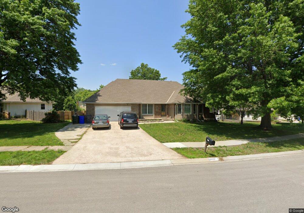
2020 E Cherokee Ln Olathe, KS 66062
Estimated Value: $353,000 - $407,000
4
Beds
4
Baths
1,971
Sq Ft
$193/Sq Ft
Est. Value
About This Home
This home is located at 2020 E Cherokee Ln, Olathe, KS 66062 and is currently estimated at $380,008, approximately $192 per square foot. 2020 E Cherokee Ln is a home located in Johnson County with nearby schools including Heritage Elementary School, Indian Trail Middle School, and Olathe South Sr High School.
Ownership History
Date
Name
Owned For
Owner Type
Purchase Details
Closed on
Nov 17, 2003
Sold by
Bank Of America Na
Bought by
Powell Russell W and Powell Sharon K
Current Estimated Value
Home Financials for this Owner
Home Financials are based on the most recent Mortgage that was taken out on this home.
Original Mortgage
$205,485
Outstanding Balance
$91,760
Interest Rate
5.93%
Mortgage Type
VA
Estimated Equity
$288,248
Create a Home Valuation Report for This Property
The Home Valuation Report is an in-depth analysis detailing your home's value as well as a comparison with similar homes in the area
Home Values in the Area
Average Home Value in this Area
Purchase History
| Date | Buyer | Sale Price | Title Company |
|---|---|---|---|
| Powell Russell W | -- | -- |
Source: Public Records
Mortgage History
| Date | Status | Borrower | Loan Amount |
|---|---|---|---|
| Open | Powell Russell W | $205,485 |
Source: Public Records
Tax History
| Year | Tax Paid | Tax Assessment Tax Assessment Total Assessment is a certain percentage of the fair market value that is determined by local assessors to be the total taxable value of land and additions on the property. | Land | Improvement |
|---|---|---|---|---|
| 2025 | $4,287 | $44,597 | $7,787 | $36,810 |
| 2024 | $4,287 | $38,295 | $7,079 | $31,216 |
| 2023 | $4,409 | $38,503 | $6,429 | $32,074 |
| 2022 | $4,030 | $34,259 | $6,429 | $27,830 |
| 2021 | $3,949 | $31,959 | $6,429 | $25,530 |
| 2020 | $3,707 | $29,751 | $5,359 | $24,392 |
| 2019 | $3,558 | $28,371 | $5,359 | $23,012 |
| 2018 | $3,566 | $28,233 | $5,365 | $22,868 |
| 2017 | $3,283 | $25,748 | $4,871 | $20,877 |
| 2016 | $2,932 | $23,609 | $4,871 | $18,738 |
| 2015 | $2,818 | $22,712 | $4,425 | $18,287 |
| 2013 | -- | $21,436 | $4,425 | $17,011 |
Source: Public Records
Map
Nearby Homes
- 1941 E Frontier Ln
- 14747 S Homestead Dr
- 16629 W 146th Terrace
- 1924 E Sheridan Bridge Ln
- 1450 E Orleans Dr
- 1701 E Sheridan Bridge Ln
- 2225 E Taylor Dr
- Lot 4 W 144th St
- 1802 S Arrowhead Dr
- 1121 S Stagecoach Place
- 1809 S Arrowhead Dr
- 16109 W 150th St
- 1501 E Sleepy Hollow Dr
- 0 E 151st St
- 1480 E Sleepy Hollow Dr
- 1836 E 153rd Cir
- 1818 E 152nd Terrace
- 1908 S Lindenwood Dr
- 14412 S Cottonwood Dr
- 1925 E 153rd Terrace
- 2016 E Cherokee Ln
- 2024 E Cherokee Ln
- 2017 E Cherokee Place
- 2013 E Cherokee Place
- 2012 E Cherokee Ln
- 2021 E Cherokee Ln
- 2009 E Cherokee Place
- 2029 E Cherokee Ln
- 2025 E Cherokee Ln
- 2017 E Cherokee Ln
- 2008 E Cherokee Ln
- 2013 E Cherokee Ln
- 2016 E Cherokee Place
- 2005 E Cherokee Place
- 2004 E Cherokee Ln
- 2024 E Cherokee Place
- 2012 E Cherokee Place
- 2028 E Cherokee Place
- 2009 E Cherokee Ln
- 2103 E Cherokee Ln
Your Personal Tour Guide
Ask me questions while you tour the home.