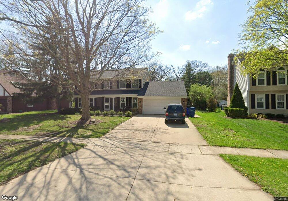
2024 Dorset Dr Wheaton, IL 60189
Stonehedge NeighborhoodEstimated Value: $614,000 - $708,000
4
Beds
3
Baths
2,254
Sq Ft
$297/Sq Ft
Est. Value
About This Home
This home is located at 2024 Dorset Dr, Wheaton, IL 60189 and is currently estimated at $669,053, approximately $296 per square foot. 2024 Dorset Dr is a home located in DuPage County with nearby schools including Whittier Elementary School, Edison Middle School, and Wheaton Warrenville South High School.
Ownership History
Date
Name
Owned For
Owner Type
Purchase Details
Closed on
Mar 23, 2022
Sold by
Runne Joan T
Bought by
Runne Trust
Current Estimated Value
Purchase Details
Closed on
Aug 8, 1997
Sold by
Skaggs Carl and Skaggs Carol
Bought by
Runne Joan T
Home Financials for this Owner
Home Financials are based on the most recent Mortgage that was taken out on this home.
Original Mortgage
$228,700
Interest Rate
7.5%
Create a Home Valuation Report for This Property
The Home Valuation Report is an in-depth analysis detailing your home's value as well as a comparison with similar homes in the area
Home Values in the Area
Average Home Value in this Area
Purchase History
| Date | Buyer | Sale Price | Title Company |
|---|---|---|---|
| Runne Trust | -- | Holmstromkennedy Pc | |
| Runne Joan T | $286,000 | -- |
Source: Public Records
Mortgage History
| Date | Status | Borrower | Loan Amount |
|---|---|---|---|
| Previous Owner | Runne Joan T | $228,700 |
Source: Public Records
Tax History
| Year | Tax Paid | Tax Assessment Tax Assessment Total Assessment is a certain percentage of the fair market value that is determined by local assessors to be the total taxable value of land and additions on the property. | Land | Improvement |
|---|---|---|---|---|
| 2024 | $11,498 | $194,390 | $51,778 | $142,612 |
| 2023 | $11,011 | $178,930 | $47,660 | $131,270 |
| 2022 | $10,949 | $169,100 | $45,040 | $124,060 |
| 2021 | $11,260 | $165,090 | $43,970 | $121,120 |
| 2020 | $11,225 | $163,550 | $43,560 | $119,990 |
| 2019 | $10,970 | $159,230 | $42,410 | $116,820 |
| 2018 | $11,277 | $161,700 | $39,960 | $121,740 |
| 2017 | $11,113 | $155,740 | $38,490 | $117,250 |
| 2016 | $10,970 | $149,520 | $36,950 | $112,570 |
| 2015 | $10,890 | $142,640 | $35,250 | $107,390 |
| 2014 | $9,211 | $119,600 | $34,740 | $84,860 |
| 2013 | $8,973 | $119,950 | $34,840 | $85,110 |
Source: Public Records
Map
Nearby Homes
- 26W055 Cree Ln
- 141 Loretto Ct
- 76 Somerset Cir
- 1127 Hibbard Rd
- 2552 Weatherbee Ln
- 30 Danada Dr
- 24 Winners Cup Cir Unit 3
- 1605 Burning Trail
- 1245 Josiah Rd
- 3S700 Delles Rd
- 121 Brighton Dr
- 1601 W Wiesbrook Rd
- 1612 Stonebridge Trail
- 1519 Foothill Dr
- Lot 1 Foothill Dr
- 1S538 Bayberry Ln
- 2068 Iron Ridge Ln
- 2126 Iron Ridge Ln
- 2048 Iron Ridge Ln
- 2127 Iron Ridge Ln
- 2030 Dorset Dr
- 2018 Dorset Dr
- 2036 Dorset Dr
- 2012 Dorset Dr
- 2025 Dorset Dr
- 2033 Dorset Dr
- 25W613 Summerfield Ct
- 2015 Dorset Dr
- 2042 Dorset Dr
- 2006 Dorset Dr
- 2039 Dorset Dr
- 25W614 Summerfield Ct
- 2007 Dorset Dr
- 25W627 Summerfield Ct
- 2047 Dorset Dr
- 2048 Dorset Dr Unit 7
- 2010 Berkshire Place
- 2000 Dorset Dr
- 2014 Berkshire Place
- 25W624 Summerfield Ct
Your Personal Tour Guide
Ask me questions while you tour the home.