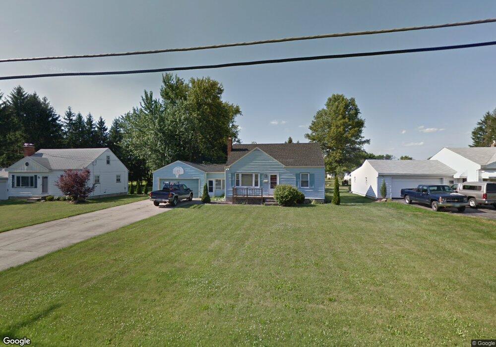
2024 Holbrook Rd Youngstown, OH 44514
Estimated Value: $123,000 - $159,000
3
Beds
1
Bath
1,248
Sq Ft
$115/Sq Ft
Est. Value
About This Home
This home is located at 2024 Holbrook Rd, Youngstown, OH 44514 and is currently estimated at $143,244, approximately $114 per square foot. 2024 Holbrook Rd is a home located in Mahoning County with nearby schools including Paul C. Bunn Elementary School, Clear Horizons Early College High School, and Chaney High School.
Ownership History
Date
Name
Owned For
Owner Type
Purchase Details
Closed on
Dec 14, 2020
Sold by
Greenaway Nicholas
Bought by
Doy Federal Credit Union
Current Estimated Value
Purchase Details
Closed on
Dec 7, 2020
Sold by
Fisher Samantha R and Nappo Samantha R
Bought by
Greenaway Nicholas
Purchase Details
Closed on
Jul 9, 1999
Sold by
Mcgoogan David M and Mcgoogan Allyson J
Bought by
Fisher Samantha R
Purchase Details
Closed on
Nov 22, 1996
Sold by
Moorhead Donna
Bought by
Mcgoogan David M and Mcgoogan Allyson
Purchase Details
Closed on
Jul 15, 1993
Bought by
Moorehead David A
Create a Home Valuation Report for This Property
The Home Valuation Report is an in-depth analysis detailing your home's value as well as a comparison with similar homes in the area
Home Values in the Area
Average Home Value in this Area
Purchase History
| Date | Buyer | Sale Price | Title Company |
|---|---|---|---|
| Doy Federal Credit Union | $65,000 | None Available | |
| Greenaway Nicholas | $65,000 | None Available | |
| Fisher Samantha R | $78,000 | -- | |
| Mcgoogan David M | $69,000 | -- | |
| Moorehead David A | -- | -- |
Source: Public Records
Mortgage History
| Date | Status | Borrower | Loan Amount |
|---|---|---|---|
| Closed | Fisher Samantha R | $0 |
Source: Public Records
Tax History Compared to Growth
Tax History
| Year | Tax Paid | Tax Assessment Tax Assessment Total Assessment is a certain percentage of the fair market value that is determined by local assessors to be the total taxable value of land and additions on the property. | Land | Improvement |
|---|---|---|---|---|
| 2024 | $2,253 | $40,170 | $7,760 | $32,410 |
| 2023 | $2,238 | $40,170 | $7,760 | $32,410 |
| 2022 | $1,883 | $25,490 | $6,940 | $18,550 |
| 2021 | $1,884 | $25,490 | $6,940 | $18,550 |
| 2020 | $1,941 | $25,490 | $6,940 | $18,550 |
| 2019 | $1,912 | $21,980 | $5,990 | $15,990 |
| 2018 | $1,849 | $21,980 | $5,990 | $15,990 |
| 2017 | $1,828 | $21,980 | $5,990 | $15,990 |
| 2016 | $1,952 | $24,950 | $7,320 | $17,630 |
| 2015 | $1,918 | $24,950 | $7,320 | $17,630 |
| 2014 | $1,906 | $24,950 | $7,320 | $17,630 |
| 2013 | $1,965 | $24,950 | $7,320 | $17,630 |
Source: Public Records
Map
Nearby Homes
- 1933 Brandon Ave
- 1919 Wingate Rd
- 576 W Harvey St
- 550 Brandon Ave
- 1913 Country Club Ave
- 2089 Shetland Ln
- 5710 Youngstown Poland Rd
- 1828 Basil Ave
- 1830 Halbert Dr
- 525 W Omar St
- 0 Woodlawn Ave
- 0 Oles Ave
- 1841 Wingate Rd
- 478 W Harvey St
- 0 Lemoyne Ave
- 1720 Sequoya Dr
- 1890 Mathews Rd
- 2296 Knollwood Ave
- 2128 Lyon Blvd
- 1894 Lealand Ave
- 2012 Holbrook Rd
- 2036 Holbrook Rd
- 2002 Holbrook Rd
- 2048 Holbrook Rd
- 2017 Brandon Ave
- 2023 Holbrook Rd
- 2060 Holbrook Rd
- 2011 Holbrook Rd
- 1986 Holbrook Rd
- 2033 Brandon Ave
- 1947 Brandon Ave
- 2037 Brandon Ave
- 1939 Brandon Ave
- 1974 Holbrook Rd
- 2001 Holbrook Rd
- 2069 Holbrook Rd
- 2047 Holbrook Rd
- 1985 Holbrook Rd
- 2041 Brandon Ave
- 2069 Holbrook Rd