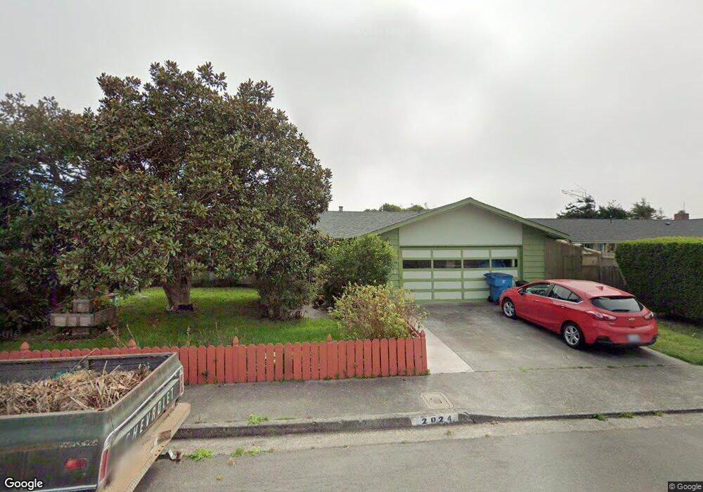
2024 Parton Ln Arcata, CA 95521
Estimated Value: $412,000 - $496,000
3
Beds
2
Baths
1,500
Sq Ft
$299/Sq Ft
Est. Value
About This Home
This home is located at 2024 Parton Ln, Arcata, CA 95521 and is currently estimated at $448,947, approximately $299 per square foot. 2024 Parton Ln is a home located in Humboldt County with nearby schools including Pacific Union Elementary School, Arcata High School, and Coastal Grove Charter School.
Ownership History
Date
Name
Owned For
Owner Type
Purchase Details
Closed on
Apr 27, 2001
Sold by
Household Finance Corp
Bought by
Mesmer Marc A and Renee Guillemin Mesmer R
Current Estimated Value
Home Financials for this Owner
Home Financials are based on the most recent Mortgage that was taken out on this home.
Original Mortgage
$137,750
Outstanding Balance
$51,892
Interest Rate
7.15%
Estimated Equity
$397,055
Purchase Details
Closed on
Feb 13, 2001
Sold by
Elam Donald F and Elam Sallee G
Bought by
Household Finance Corp
Create a Home Valuation Report for This Property
The Home Valuation Report is an in-depth analysis detailing your home's value as well as a comparison with similar homes in the area
Home Values in the Area
Average Home Value in this Area
Purchase History
| Date | Buyer | Sale Price | Title Company |
|---|---|---|---|
| Mesmer Marc A | $145,000 | Humboldt Land Title Company | |
| Household Finance Corp | $116,000 | Humboldt Land Title Company |
Source: Public Records
Mortgage History
| Date | Status | Borrower | Loan Amount |
|---|---|---|---|
| Open | Mesmer Marc A | $137,750 |
Source: Public Records
Tax History Compared to Growth
Tax History
| Year | Tax Paid | Tax Assessment Tax Assessment Total Assessment is a certain percentage of the fair market value that is determined by local assessors to be the total taxable value of land and additions on the property. | Land | Improvement |
|---|---|---|---|---|
| 2025 | $2,369 | $218,470 | $78,346 | $140,124 |
| 2024 | $2,369 | $214,187 | $76,810 | $137,377 |
| 2023 | $2,367 | $209,988 | $75,304 | $134,684 |
| 2022 | $2,354 | $205,872 | $73,828 | $132,044 |
| 2021 | $2,339 | $201,836 | $72,381 | $129,455 |
| 2020 | $2,232 | $199,767 | $71,639 | $128,128 |
| 2019 | $2,197 | $195,851 | $70,235 | $125,616 |
| 2018 | $2,054 | $192,011 | $68,858 | $123,153 |
| 2017 | $2,022 | $188,247 | $67,508 | $120,739 |
| 2016 | $1,987 | $184,557 | $66,185 | $118,372 |
| 2015 | $1,950 | $181,785 | $65,191 | $116,594 |
| 2014 | $1,921 | $178,225 | $63,914 | $114,311 |
Source: Public Records
Map
Nearby Homes
- 2033 Ernest Way
- 3106 Brian Ct
- 3659 Spear Ave
- 3028 Alliance Rd
- 1283 Poplar Dr
- 2705 Alliance Rd
- 5028 Ponderosa Way
- 3000 Saint Louis Rd
- 1810 Stewart Ave
- 970 Courtyard Cir
- 2700 Meadow Creek Way
- 402 Tanglewood Rd
- 3763 Coombs Ct
- 2474 Seidel Rd
- 2470 Eye St
- 2565 Todd Ct
- 2310 Eye St
- 1002 Diamond Dr
- 2925 Evergreen Ave
- 429 Evergreen Ave