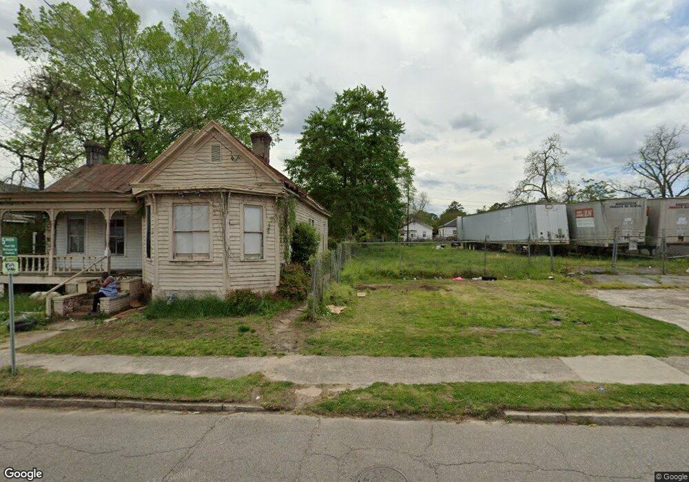
2030 Broad St Augusta, GA 30904
West End Neighborhood
2
Beds
1
Bath
1,074
Sq Ft
4,356
Sq Ft Lot
About This Home
This home is located at 2030 Broad St, Augusta, GA 30904. 2030 Broad St is a home located in Richmond County with nearby schools including Lamar Elementary School, W.S. Hornsby Elementary School, and Johnson Magnet.
Ownership History
Date
Name
Owned For
Owner Type
Purchase Details
Closed on
Sep 26, 2014
Sold by
Clay Donald
Bought by
Mercy Ministries Inc
Purchase Details
Closed on
Mar 16, 2009
Sold by
Sealey Anthony Y
Bought by
Clay Donald
Purchase Details
Closed on
Aug 28, 2002
Sold by
Ennis Larry
Bought by
Sealey Anthony Y
Purchase Details
Closed on
Aug 26, 2002
Sold by
U S Bank National Assn
Bought by
Davison Tony and Ennis Larry
Purchase Details
Closed on
Apr 3, 2001
Sold by
Pamela D Rofs Thompkins Woodrow C Rofs and Pamela D Rofs Thompkins Thompki
Bought by
U S Bank National Assn and Eqcc Home Equity Loan Trust 1998-3
Purchase Details
Closed on
Sep 17, 1997
Sold by
Watkins Wilson M
Bought by
Thompkins Woodrow C and Thompkins Pamela D
Home Financials for this Owner
Home Financials are based on the most recent Mortgage that was taken out on this home.
Original Mortgage
$22,000
Interest Rate
6.89%
Mortgage Type
Seller Take Back
Purchase Details
Closed on
Mar 4, 1997
Sold by
Hastings Robert R B
Bought by
Watkins Wilson M
Purchase Details
Closed on
Jun 25, 1996
Sold by
Stout Forrest E
Bought by
Watkins Wilson M
Purchase Details
Closed on
Jul 18, 1991
Sold by
Decatur Federal Sav
Bought by
Stout Forrest E
Purchase Details
Closed on
Feb 5, 1991
Sold by
Key James R By Atty
Bought by
Decatur Federal Sav
Purchase Details
Closed on
May 1, 1986
Purchase Details
Closed on
Jun 1, 1983
Create a Home Valuation Report for This Property
The Home Valuation Report is an in-depth analysis detailing your home's value as well as a comparison with similar homes in the area
Home Values in the Area
Average Home Value in this Area
Purchase History
| Date | Buyer | Sale Price | Title Company |
|---|---|---|---|
| Mercy Ministries Inc | -- | -- | |
| Clay Donald | -- | None Available | |
| Sealey Anthony Y | -- | -- | |
| Sealy Anthony Y | -- | -- | |
| Davison Tony | $4,500 | -- | |
| Davidson Tony | $4,500 | -- | |
| U S Bank National Assn | $9,400 | -- | |
| U S Bank National Assoc | $9,400 | -- | |
| Thompkins Woodrow C | $23,000 | -- | |
| Thompkins Woodrow C | $23,000 | -- | |
| Watkins Wilson M | -- | -- | |
| Watkins Wilson M | $4,300 | -- | |
| Stout Forrest E | $400,000 | -- | |
| Decatur Federal Sav | $13,500 | -- | |
| -- | $12,500 | -- | |
| -- | $8,000 | -- |
Source: Public Records
Mortgage History
| Date | Status | Borrower | Loan Amount |
|---|---|---|---|
| Previous Owner | Thompkins Woodrow C | $22,000 |
Source: Public Records
Tax History
| Year | Tax Paid | Tax Assessment Tax Assessment Total Assessment is a certain percentage of the fair market value that is determined by local assessors to be the total taxable value of land and additions on the property. | Land | Improvement |
|---|---|---|---|---|
| 2025 | $295 | $3,318 | $3,318 | $0 |
| 2024 | $295 | $3,318 | $3,318 | $0 |
| 2023 | $85 | $3,318 | $3,318 | $0 |
| 2022 | $85 | $3,318 | $3,318 | $0 |
| 2021 | $85 | $3,318 | $3,318 | $0 |
| 2020 | $71 | $2,000 | $2,000 | $0 |
| 2019 | $71 | $2,000 | $2,000 | $0 |
| 2018 | $71 | $2,000 | $2,000 | $0 |
| 2017 | $0 | $2,000 | $2,000 | $0 |
| 2016 | -- | $2,000 | $2,000 | $0 |
| 2015 | $72 | $2,000 | $2,000 | $0 |
| 2014 | $72 | $2,000 | $2,000 | $0 |
Source: Public Records
Map
Nearby Homes
Your Personal Tour Guide
Ask me questions while you tour the home.