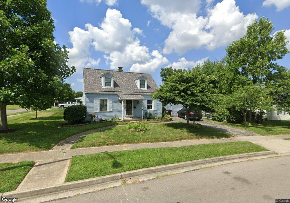
2035 Malcom Dr Dayton, OH 45420
Estimated Value: $159,000 - $184,000
4
Beds
1
Bath
1,008
Sq Ft
$172/Sq Ft
Est. Value
About This Home
This home is located at 2035 Malcom Dr, Dayton, OH 45420 and is currently estimated at $173,688, approximately $172 per square foot. 2035 Malcom Dr is a home located in Montgomery County with nearby schools including Greenmont Elementary School, Kettering Middle School, and Kettering Fairmont High School.
Ownership History
Date
Name
Owned For
Owner Type
Purchase Details
Closed on
Dec 15, 2004
Sold by
Hud
Bought by
Hendrixson Michael D
Current Estimated Value
Purchase Details
Closed on
Nov 1, 2004
Sold by
Little Michael W and Little Bridgette L
Bought by
Hud
Purchase Details
Closed on
Oct 29, 1997
Sold by
Rawson Richard L and Rawson Beverly T
Bought by
Little Michael W and Little Bridgette L
Create a Home Valuation Report for This Property
The Home Valuation Report is an in-depth analysis detailing your home's value as well as a comparison with similar homes in the area
Home Values in the Area
Average Home Value in this Area
Purchase History
| Date | Buyer | Sale Price | Title Company |
|---|---|---|---|
| Hendrixson Michael D | $68,500 | Lakeside Title & Escrow Agen | |
| Hud | $78,000 | None Available | |
| Little Michael W | $73,000 | Midwest Abstract Company |
Source: Public Records
Tax History
| Year | Tax Paid | Tax Assessment Tax Assessment Total Assessment is a certain percentage of the fair market value that is determined by local assessors to be the total taxable value of land and additions on the property. | Land | Improvement |
|---|---|---|---|---|
| 2025 | $2,940 | $45,350 | $11,010 | $34,340 |
| 2024 | $2,858 | $45,350 | $11,010 | $34,340 |
| 2023 | $2,858 | $45,350 | $11,010 | $34,340 |
| 2022 | $2,531 | $31,660 | $7,700 | $23,960 |
| 2021 | $2,344 | $31,660 | $7,700 | $23,960 |
| 2020 | $2,351 | $31,660 | $7,700 | $23,960 |
| 2019 | $2,419 | $28,820 | $7,700 | $21,120 |
| 2018 | $2,431 | $28,820 | $7,700 | $21,120 |
| 2017 | $2,243 | $28,820 | $7,700 | $21,120 |
| 2016 | $2,095 | $25,240 | $7,700 | $17,540 |
| 2015 | $2,073 | $25,240 | $7,700 | $17,540 |
| 2014 | $2,073 | $25,240 | $7,700 | $17,540 |
| 2012 | -- | $29,940 | $8,400 | $21,540 |
Source: Public Records
Map
Nearby Homes
- 2167 W Bataan Dr
- 2216 Culver Ave
- 2291 Patterson Rd
- 2040 Courtland Ave
- 1534 Horlacher Ave
- 2112 Patterson Rd
- 2408 Homeland Ct
- 1513 Horlacher Ave
- 1618 Briedweng Ave Unit 1616
- 1529 Watervliet Ave
- 2817 Kennedy Ave
- 1421 Flesher Ave
- 1525 Farrington Dr
- 2904 Kingston Ave
- 1629 Beaver Creek Ln
- 2600 Ghent Ave
- 5123 Haverfield Rd
- 1436 Glenn Abbey Dr
- 2051 S Smithville Rd
- 2758 Sutton Ave
- 2167 Adventure Dr
- 2029 Malcom Dr
- 2163 Adventure Dr
- 2174 Adventure Dr
- 2159 Adventure Dr
- 2030 Malcom Dr
- 2034 Malcom Dr
- 2026 Malcom Dr
- 2170 Adventure Dr
- 2038 Malcom Dr
- 2034 W Bataan Dr
- 2021 Malcom Dr
- 2030 W Bataan Dr
- 2022 Malcom Dr
- 2166 Adventure Dr
- 2042 Malcom Dr
- 2042 W Bataan Dr
- 2045 Malcom Dr
- 2026 W Bataan Dr
- 2162 Adventure Dr
Your Personal Tour Guide
Ask me questions while you tour the home.