Estimated Value: $330,912 - $361,000
5
Beds
3
Baths
2,655
Sq Ft
$132/Sq Ft
Est. Value
About This Home
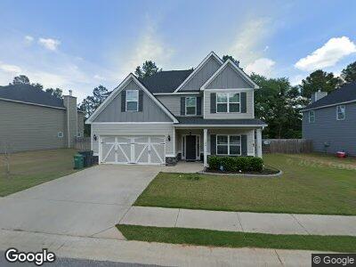
This home is located at 204 Wildfire Way, Perry, GA 31069 and is currently estimated at $349,728, approximately $131 per square foot. 204 Wildfire Way is a home located in Houston County with nearby schools including Langston Road Elementary School, Mossy Creek Middle School, and Perry High School.
Ownership History
Date
Name
Owned For
Owner Type
Purchase Details
Closed on
Mar 26, 2019
Sold by
Huff Christopher E
Bought by
Shaver Phillip
Current Estimated Value
Home Financials for this Owner
Home Financials are based on the most recent Mortgage that was taken out on this home.
Original Mortgage
$242,000
Interest Rate
4.3%
Mortgage Type
VA
Purchase Details
Closed on
May 29, 2018
Sold by
Edgar Hughston Builder Inc
Bought by
Aff Christopher E
Home Financials for this Owner
Home Financials are based on the most recent Mortgage that was taken out on this home.
Original Mortgage
$227,540
Interest Rate
4.5%
Mortgage Type
FHA
Create a Home Valuation Report for This Property
The Home Valuation Report is an in-depth analysis detailing your home's value as well as a comparison with similar homes in the area
Home Values in the Area
Average Home Value in this Area
Purchase History
| Date | Buyer | Sale Price | Title Company |
|---|---|---|---|
| Shaver Phillip | $242,000 | The Cooper Law Firm Llc | |
| Aff Christopher E | $231,800 | None Available |
Source: Public Records
Mortgage History
| Date | Status | Borrower | Loan Amount |
|---|---|---|---|
| Open | Shaver Phillip | $241,395 | |
| Closed | Piere Russel A | $240,847 | |
| Closed | Shaver Phillip | $242,000 | |
| Previous Owner | Aff Christopher E | $227,540 |
Source: Public Records
Tax History Compared to Growth
Tax History
| Year | Tax Paid | Tax Assessment Tax Assessment Total Assessment is a certain percentage of the fair market value that is determined by local assessors to be the total taxable value of land and additions on the property. | Land | Improvement |
|---|---|---|---|---|
| 2024 | $4,855 | $132,120 | $10,000 | $122,120 |
| 2023 | $4,663 | $126,040 | $10,000 | $116,040 |
| 2022 | $2,592 | $112,720 | $10,000 | $102,720 |
| 2021 | $2,274 | $98,360 | $10,000 | $88,360 |
| 2020 | $2,061 | $88,720 | $11,600 | $77,120 |
| 2019 | $2,061 | $88,720 | $11,600 | $77,120 |
| 2018 | $115 | $11,600 | $11,600 | $0 |
Source: Public Records
Map
Nearby Homes
- 103 Bluestem Ct
- 228 Goldenrod Trail
- 217 Goldenrod Trail
- 102 Wayland Cir
- 102 Wildfire Way
- 208 Wild Azalea Dr
- 305 Dog Fennel Ln
- 107 Bald Cypress Dr Unit 88G
- 110 Bald Cypress Dr Unit 69G
- 102 Black Birch Rd Unit 83G
- 109 Bald Cypress Dr Unit 87G
- 104 Black Birch Rd Unit 84G
- 111 Bald Cypress Dr Unit 86G
- 106 Black Birch Rd Unit 85G
- 114 Bald Cypress Dr Unit 67G
- 204 Wildfire Way Unit 224
- 204 Wildfire Way
- 202 Wildfire Way Unit 225
- 202 Wildfire Way
- 206 Wildfire Way Unit 223
- 206 Wild Fire Way Unit 223
- 0 Wildfire Way Unit 8658931
- 0 Wildfire Way Unit 8504877
- 0 Wildfire Way Unit 8757328
- 0 Wildfire Way Unit 220 8830172
- 0 Wildfire Way Unit 293 8887647
- 0 Wildfire Way Unit 8891975
- 0 Wildfire Way Unit 225 8269634
- 0 Wildfire Way Unit 283 8283503
- 0 Wildfire Way Unit 228 8299594
- 0 Wildfire Way Unit 227 8300433
- 0 Wildfire Way Unit 222 8302357
- 0 Wildfire Way Unit 224 8303233
- 0 Wildfire Way Unit 221 8303086
- 0 Wildfire Way Unit 226 8307281