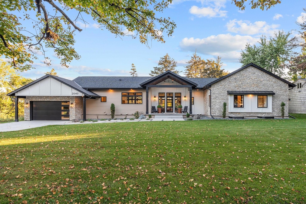

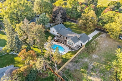
2040 Edgcumbe Rd Saint Paul, MN 55116
Highland Park NeighborhoodEstimated payment $10,077/month
Highlights
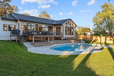
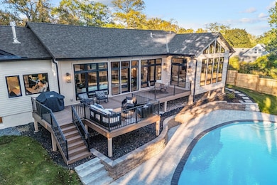
- Heated In Ground Pool
- 21,780 Sq Ft lot
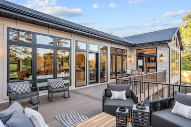
- Deck
- Highland Park Senior High Rated A
- Viking Appliances
- Recreation Room
About This Home
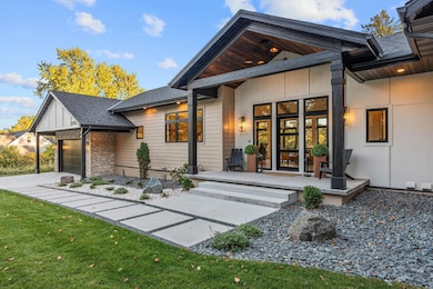
Welcome to the newest addition to historic Edgcumbe in St. Paul. This stunning 4,000-sq-ft custom new build rests on an oversized 1⁄2-acre lot and features 6 bedrooms, 5 baths, and soaring 10’ main-level walls crowned by 18’ vaulted ceilings that fill the home with natural light through a dramatic wall of Andersen windows. Designed for elevated everyday living, the open layout showcases real oak flooring, DuraSupreme quartersawn cabinetry, and a chef’s kitchen with Viking 6-burner range, Miele paneled dishwasher, Fisher & Paykel refrigerator, and quartz counters. Three gas fireplaces and spa-inspired tile baths, including a serene primary suite with double shower and stone soaking tub, offer warmth and luxury. Step outside to the expansive 40-foot Trex deck overlooking the sparkling pool and stamped concrete surround - perfect for entertaining or quiet morning coffee. With LP Diamond Coated Siding, EV-ready garage, and timeless design throughout, this home embodies modern luxury for the discerning buyer who craves natural light and comfort.
Home Details
Home Type
- Single Family
Est. Annual Taxes
- $10,238
Year Built
- Built in 1951
Lot Details
- 0.5 Acre Lot
- Lot Dimensions are 170 x 130
- Property is Fully Fenced
- Privacy Fence
- Chain Link Fence
- Many Trees
Parking
- 2 Car Attached Garage
Interior Spaces
- 1-Story Property
- Wet Bar
- Vaulted Ceiling
- 3 Fireplaces
- Gas Fireplace
- Family Room
- Combination Dining and Living Room
- Recreation Room
- Finished Basement
- Basement Fills Entire Space Under The House
Kitchen
- Range
- Microwave
- Dishwasher
- Viking Appliances
- The kitchen features windows
Bedrooms and Bathrooms
- 6 Bedrooms
- Soaking Tub
Laundry
- Laundry Room
- Dryer
- Washer
Outdoor Features
- Heated In Ground Pool
- Deck
Utilities
- Forced Air Heating and Cooling System
Community Details
- No Home Owners Association
- Lanes Edgcumbe Hills Subdivision
Listing and Financial Details
- Assessor Parcel Number 152823330057
Map
Home Values in the Area
Average Home Value in this Area
Tax History
| Year | Tax Paid | Tax Assessment Tax Assessment Total Assessment is a certain percentage of the fair market value that is determined by local assessors to be the total taxable value of land and additions on the property. | Land | Improvement |
|---|---|---|---|---|
| 2025 | $13,230 | $825,200 | $364,500 | $460,700 |
| 2023 | $13,230 | $795,700 | $552,500 | $243,200 |
| 2022 | $12,860 | $798,000 | $552,500 | $245,500 |
| 2021 | $12,480 | $718,900 | $552,500 | $166,400 |
| 2020 | $13,012 | $721,800 | $552,500 | $169,300 |
| 2019 | $14,140 | $702,000 | $552,500 | $149,500 |
| 2018 | $11,478 | $752,500 | $552,500 | $200,000 |
| 2017 | $12,856 | $660,900 | $552,500 | $108,400 |
| 2016 | $13,964 | $0 | $0 | $0 |
| 2015 | $13,870 | $732,300 | $508,300 | $224,000 |
| 2014 | $13,290 | $0 | $0 | $0 |
Property History
| Date | Event | Price | List to Sale | Price per Sq Ft |
|---|---|---|---|---|
| 11/10/2025 11/10/25 | Price Changed | $1,750,000 | -5.4% | $444 / Sq Ft |
| 10/13/2025 10/13/25 | For Sale | $1,850,000 | -- | $469 / Sq Ft |
Purchase History
| Date | Type | Sale Price | Title Company |
|---|---|---|---|
| Warranty Deed | $425,000 | Legacy Title | |
| Deed | $600,000 | -- |
Mortgage History
| Date | Status | Loan Amount | Loan Type |
|---|---|---|---|
| Previous Owner | $480,000 | New Conventional |
Source: NorthstarMLS
MLS Number: 6803510
APN: 15-28-23-33-0007
Disclaimer: Certain information contained herein is derived from information provided by parties other than Homes.com. All information provided is deemed reliable, but is not guaranteed to be accurate and should be independently verified.
![]() Based on information submitted to the MLS GRID. All data is obtained from various sources and may not have been verified by broker or MLS GRID. Supplied Open House Information is subject to change without notice. All information should be independently reviewed and verified for accuracy. Properties may or may not be listed by the office/agent presenting the information. Some IDX listings have been excluded from this website.
Based on information submitted to the MLS GRID. All data is obtained from various sources and may not have been verified by broker or MLS GRID. Supplied Open House Information is subject to change without notice. All information should be independently reviewed and verified for accuracy. Properties may or may not be listed by the office/agent presenting the information. Some IDX listings have been excluded from this website.
The Digital Millennium Copyright Act of 1998, 17 U.S.C. § 512 (the “DMCA”) provides recourse for copyright owners who believe that material appearing on the Internet infringes their rights under U.S. copyright law. If you believe in good faith that any content or material made available in connection with our website or services infringes your copyright, you (or your agent) may send us a notice requesting that the content or material be removed, or access to it blocked.
Notices must be sent in writing by email to DMCAnotice@MLSGrid.com.
The DMCA requires that your notice of alleged copyright infringement include the following information:
(1) description of the copyrighted work that is the subject of claimed infringement;
(2) description of the alleged infringing content and information sufficient to permit us to locate the content;
(3) contact information for you, including your address, telephone number and email address;
(4) a statement by you that you have a good faith belief that the content in the manner complained of is not authorized by the copyright owner, or its agent, or by the operation of any law;
(5) a statement by you, signed under penalty of perjury, that the information in the notification is accurate and that you have the authority to enforce the copyrights that are claimed to be infringed; and
(6) a physical or electronic signature of the copyright owner or a person authorized to act on the copyright owner’s behalf. Failure to include all of the above information may result in the delay of the processing of your complaint.
- 2310 Benson Ave Unit H
- 2275 Youngman Ave Unit 308W
- 1759 Montreal Ave
- 1775 Morgan Ave
- 1716 Beechwood Ave
- 1022 Fairview Ave S
- 850 Syndicate St S
- 1752 Bohland Ave
- 1619 Edgcumbe Rd
- 1841 W Saunders Ave
- 1460 Eleanor Ave
- 1776 Ford Pkwy
- 1778 Ford Pkwy
- 1501 Eleanor Ave
- 1068 Prior Ave S
- 1913 Morgan Ave
- 1800 Graham Ave Unit 334
- 1800 Graham Ave Unit 325
- 1166 Colette Place
- 1075 Saint Paul Ave
- 2235 Rockwood Ave
- 2061 Shepard Rd
- 796 Stewart Ave
- 796 Stewart Ave
- 1372 Saint Paul Ave
- 1330-1344 Saint Paul Ave
- 1735 Graham Ave
- 1115 Elway St
- 1745 Graham Ave
- 1720 Norfolk Ave
- 1604 Bayard Ave
- 1061 Montreal Ave
- 1966 Rome Ave
- 2034 Yorkshire Ave
- 931-945 St Paul Ave
- 845 Cleveland Ave S
- 1015 Sibley Memorial Hwy
- 1532 Randolph Ave
- 1440 Randolph Ave
- 725 Cleveland Ave S
