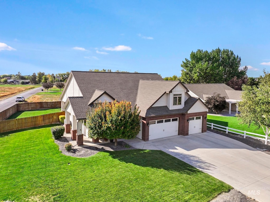
205 Edwards Dr Twin Falls, ID 83301
Estimated payment $3,282/month
Highlights
- Recreation Room
- Main Floor Primary Bedroom
- 3 Car Attached Garage
- Wood Flooring
- Built-In Double Oven
- Walk-In Closet
About This Home
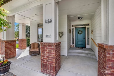
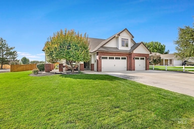
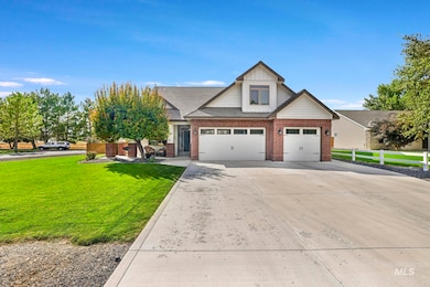
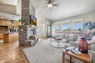
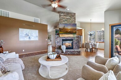
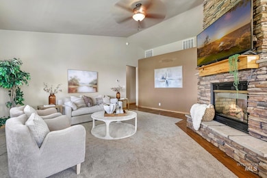
HUGE LOT WITH GREAT FEATURES! This brick home on a large lot has been exceptionally well cared for. With fresh exterior paint and timeless brick, you’ll love the wraparound front porch and spacious three-car garage. Inside, a welcoming entryway leads to a private office/ forth bedroom. The kitchen is a true centerpiece with a double-sided fireplace, beautiful cabinetry, a large island, double ovens, and a generous pantry. The living room showcases stunning windows that overlook the private backyard. The primary suite is expansive, featuring two closets, dual vanities, and a large tiled shower. The guest bedroom has been recently updated with new LVT flooring, and the guest bathroom is conveniently located nearby. A spacious laundry room provides excellent storage. Upstairs, you’ll find a third bedroom, plus a bonus room area and full bathroom. The backyard is designed for enjoyment with full fencing, no direct neighbors, a large storage shed, dog run, 220 power, patio gas line and a fire pit area. Come see this wonderful home today.
Listing Agent
Keller Williams Sun Valley Southern Idaho Brokerage Phone: 208-734-1991 Listed on: 09/12/2025

Home Details
Home Type
- Single Family
Est. Annual Taxes
- $2,726
Year Built
- Built in 2007
Lot Details
- 0.33 Acre Lot
- Lot Dimensions are 156x95
- Dog Run
- Property is Fully Fenced
- Wood Fence
- Sprinkler System
HOA Fees
- $92 Monthly HOA Fees
Parking
- 3 Car Attached Garage
Home Design
- Brick Exterior Construction
- Composition Roof
- HardiePlank Type
Interior Spaces
- 2,410 Sq Ft Home
- 2-Story Property
- Gas Fireplace
- Recreation Room
Kitchen
- Built-In Double Oven
- Built-In Range
- Microwave
- Dishwasher
- Kitchen Island
- Laminate Countertops
- Disposal
Flooring
- Wood
- Carpet
- Laminate
Bedrooms and Bathrooms
- 4 Bedrooms | 3 Main Level Bedrooms
- Primary Bedroom on Main
- En-Suite Primary Bedroom
- Walk-In Closet
- 3 Bathrooms
Laundry
- Laundry Room
- Dryer
- Washer
Outdoor Features
- Outdoor Storage
Schools
- Rock Creek Elementary School
- Robert Stuart Middle School
- Canyon Ridge High School
Utilities
- Forced Air Heating and Cooling System
- Heating System Uses Natural Gas
- Shared Well
- Water Softener is Owned
- Septic Tank
Listing and Financial Details
- Assessor Parcel Number RPO590100D002B
Map
Home Values in the Area
Average Home Value in this Area
Tax History
| Year | Tax Paid | Tax Assessment Tax Assessment Total Assessment is a certain percentage of the fair market value that is determined by local assessors to be the total taxable value of land and additions on the property. | Land | Improvement |
|---|---|---|---|---|
| 2025 | $1,717 | $532,753 | $108,183 | $424,570 |
| 2024 | $2,010 | $532,753 | $108,183 | $424,570 |
| 2023 | $954 | $509,263 | $108,183 | $401,080 |
| 2022 | $2,591 | $468,310 | $67,230 | $401,080 |
| 2021 | $1,233 | $378,320 | $61,930 | $316,390 |
| 2020 | $1,560 | $333,580 | $61,930 | $271,650 |
| 2019 | $2,542 | $310,490 | $49,700 | $260,790 |
| 2018 | $1,332 | $292,324 | $41,954 | $250,370 |
| 2017 | $2,234 | $275,624 | $41,954 | $233,670 |
| 2016 | $2,206 | $257,654 | $0 | $0 |
| 2015 | $3,459 | $257,654 | $41,954 | $215,700 |
| 2012 | -- | $244,376 | $0 | $0 |
Property History
| Date | Event | Price | List to Sale | Price per Sq Ft |
|---|---|---|---|---|
| 10/29/2025 10/29/25 | Price Changed | $564,900 | -0.9% | $234 / Sq Ft |
| 09/12/2025 09/12/25 | For Sale | $569,900 | -- | $236 / Sq Ft |
Purchase History
| Date | Type | Sale Price | Title Company |
|---|---|---|---|
| Quit Claim Deed | -- | Accommodation | |
| Deed | -- | Title One Twin Falls | |
| Interfamily Deed Transfer | -- | None Available |
Mortgage History
| Date | Status | Loan Amount | Loan Type |
|---|---|---|---|
| Previous Owner | $273,000 | Credit Line Revolving |
Source: Intermountain MLS
MLS Number: 98961489
APN: RPO590100D002BA
Disclaimer: Certain information contained herein is derived from information provided by parties other than Homes.com. All information provided is deemed reliable, but is not guaranteed to be accurate and should be independently verified.
![]() IDX information is provided exclusively for consumers’ personal, non-commercial use, that it may not be used for any purpose other than to identify prospective properties consumers may be interested in purchasing. IMLS does not assume any liability for missing or inaccurate data.
IDX information is provided exclusively for consumers’ personal, non-commercial use, that it may not be used for any purpose other than to identify prospective properties consumers may be interested in purchasing. IMLS does not assume any liability for missing or inaccurate data.
Information provided by IMLS is deemed reliable but not guaranteed.
- 4156 N 2500 E
- 1135 Latitude Cir
- 1450 Creekside Way
- 1015 Cheney Dr W
- 2005 Rivercrest Dr
- 1046 Warrior St
- 835 Shadowleaf Ave
- 950 Sparks St N
- 122 W Falls Ave W
- 677 Paradise Plaza Unit 101
- 797 Meadows Dr
- 629 Quincy St
- 472 Jefferson St
- 230 Richardson Dr Unit 230 Richardson Dr
- 276 Adams St Unit B
- 702 Filer Ave Unit 498 Fillmore
- 651 2nd Ave N
- 833 Shoshone St N
- 212 Juniper St N
- 151 2nd Ave E