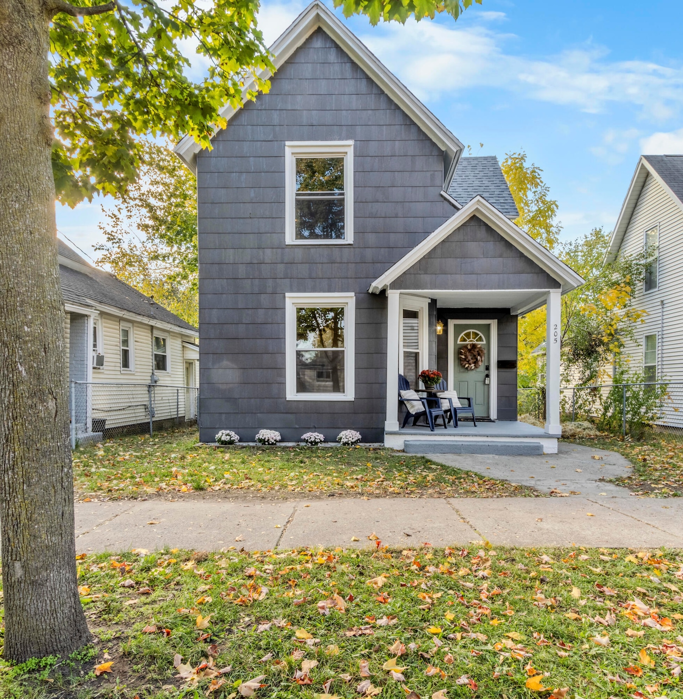
205 Lane Ave SW Grand Rapids, MI 49504
SWAN NeighborhoodEstimated payment $1,576/month
Highlights
- Traditional Architecture
- Mud Room
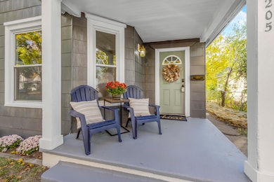
- Covered Patio or Porch
- Bonus Room
- No HOA
- Walk-In Pantry
About This Home
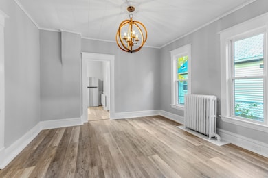
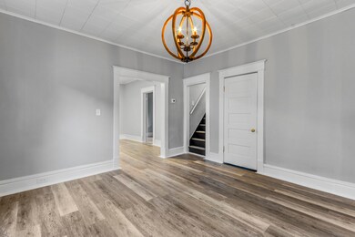
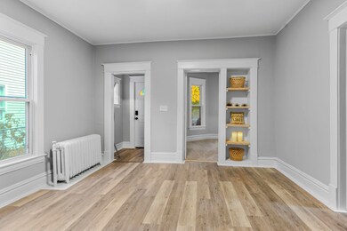
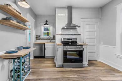
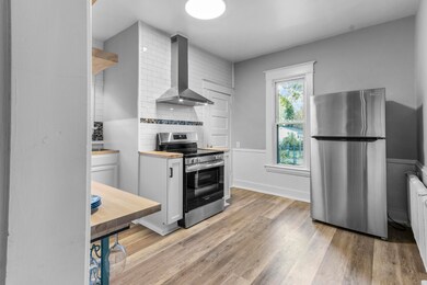
This beautifully renovated 4-bedroom, 1-bath home blends style, comfort, and functionality. Step inside to a bright, inviting interior with a fully updated kitchen featuring walk-in pantry, butcher block countertops, brand-new appliances, subway tile backsplash, and open shelving — perfect for everyday living and entertaining. The main-floor showcases 2 bedrooms; the bathroom offers a clean, timeless look, while warm-toned flooring flows through the living and dining areas. Upstairs, you'll find spacious 2 bedrooms and a bonus room ideal for a home office or playroom. Updates include a new roof (2025) and new washer and dryer. Outside, enjoy the fenced yard with newly planted grass — great for pets or gatherings. Conveniently located near downtown Grand Rapids, local restaurants, and parks, this move-in-ready home combines modern updates with classic charm. Seller is a licensed Realtor in the state of MI.
Home Details
Home Type
- Single Family
Est. Annual Taxes
- $1,886
Year Built
- Built in 1895
Lot Details
- 3,149 Sq Ft Lot
- Lot Dimensions are 31.5 x 100
- Chain Link Fence
- Level Lot
- Back Yard Fenced
- Property is zoned N/A, N/A
Home Design
- Traditional Architecture
- Shingle Roof
- Wood Siding
Interior Spaces
- 1,664 Sq Ft Home
- 2-Story Property
- Replacement Windows
- Mud Room
- Living Room
- Dining Room
- Bonus Room
- Basement
- Michigan Basement
Kitchen
- Walk-In Pantry
- Range
- Dishwasher
Flooring
- Carpet
- Vinyl
Bedrooms and Bathrooms
- 4 Bedrooms | 2 Main Level Bedrooms
- 1 Full Bathroom
Laundry
- Laundry in Hall
- Laundry on main level
- Dryer
- Washer
Outdoor Features
- Covered Patio or Porch
Utilities
- Heating System Uses Natural Gas
- Hot Water Heating System
- Natural Gas Water Heater
- High Speed Internet
- Internet Available
- Phone Available
- Cable TV Available
Community Details
- No Home Owners Association
Map
Home Values in the Area
Average Home Value in this Area
Tax History
| Year | Tax Paid | Tax Assessment Tax Assessment Total Assessment is a certain percentage of the fair market value that is determined by local assessors to be the total taxable value of land and additions on the property. | Land | Improvement |
|---|---|---|---|---|
| 2025 | $1,814 | $97,200 | $0 | $0 |
| 2024 | $1,814 | $89,700 | $0 | $0 |
| 2023 | $1,800 | $72,700 | $0 | $0 |
| 2022 | $1,710 | $67,900 | $0 | $0 |
| 2021 | $1,667 | $59,800 | $0 | $0 |
| 2020 | $1,611 | $53,100 | $0 | $0 |
| 2019 | $1,649 | $42,200 | $0 | $0 |
| 2018 | $1,599 | $33,800 | $0 | $0 |
| 2017 | $1,560 | $29,300 | $0 | $0 |
| 2016 | $1,567 | $26,300 | $0 | $0 |
| 2015 | $1,044 | $26,300 | $0 | $0 |
| 2013 | -- | $27,700 | $0 | $0 |
Property History
| Date | Event | Price | List to Sale | Price per Sq Ft |
|---|---|---|---|---|
| 11/13/2025 11/13/25 | Price Changed | $269,900 | -1.8% | $162 / Sq Ft |
| 10/31/2025 10/31/25 | For Sale | $274,900 | -- | $165 / Sq Ft |
Purchase History
| Date | Type | Sale Price | Title Company |
|---|---|---|---|
| Quit Claim Deed | -- | None Available | |
| Land Contract | -- | None Available | |
| Land Contract | -- | None Available | |
| Warranty Deed | $9,500 | Trans | |
| Quit Claim Deed | -- | -- | |
| Quit Claim Deed | -- | -- |
Mortgage History
| Date | Status | Loan Amount | Loan Type |
|---|---|---|---|
| Closed | $0 | Land Contract Argmt. Of Sale |
Source: MichRIC
MLS Number: 25055869
APN: 41-13-26-453-024
Disclaimer: Certain information contained herein is derived from information provided by parties other than Homes.com. All information provided is deemed reliable, but is not guaranteed to be accurate and should be independently verified.
![]() Information is deemed reliable but not guaranteed.
Information is deemed reliable but not guaranteed.
Copyright 2025 MichRIC, LLC. All rights reserved.
- 1023 Pulawski St SW
- 1036 Park St SW
- 210 Mardell Place SW
- 935 Watson St SW
- 318 Hogadone Ave SW
- 856 Watson St SW
- 844 Watson St SW
- 288 Garfield Ave SW
- 914 Fulton St W
- 827 Fulton St W
- 823 Fulton St W
- 945 Veto St NW
- 12 Valley Ave SW
- 1015 California St NW
- 1128 California St NW
- 859 Lake Michigan Dr NW
- 1209 California St NW
- 748 Lake Michigan Dr NW
- 1325 Fulton St W
- 205 Lane Ave NW
- 921 Dayton St SW Unit 2
- 851 Watson St SW Unit 1
- 1205 Dayton St SW
- 937 Fulton St W
- 759 Veto St NW Unit 2
- 1301 Fulton St W
- 616 Fulton St W
- 45 Lexington Ave NW
- 35 Richards Ave NW
- 52 John Ball Park Dr NW
- 601 Lake Michigan Dr
- 470 Market Ave SW
- 306 Gold Ave NW
- 306 Gold Ave NW
- 234 Market Ave SW
- 625 Bridge St NW
- 511 Bridge St NW
- 449-499 Bridge St NW
- 420-421 Alabama Ave
- 212 Cesar e Chavez Ave SW
