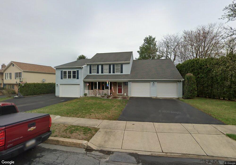
205 Michael Dr Reading, PA 19608
Estimated Value: $357,000 - $440,000
4
Beds
3
Baths
2,203
Sq Ft
$179/Sq Ft
Est. Value
About This Home
This home is located at 205 Michael Dr, Reading, PA 19608 and is currently estimated at $393,766, approximately $178 per square foot. 205 Michael Dr is a home located in Berks County with nearby schools including Shiloh Hills Elementary School, Wilson Southern Middle School, and Wilson High School.
Ownership History
Date
Name
Owned For
Owner Type
Purchase Details
Closed on
Jul 8, 2011
Sold by
Schulze Bryan E and Schulze John E
Bought by
Schulze Bryan E
Current Estimated Value
Purchase Details
Closed on
Jan 26, 2007
Sold by
Kolb Rickey J
Bought by
Schulze Bryan E and Schulze John E
Home Financials for this Owner
Home Financials are based on the most recent Mortgage that was taken out on this home.
Original Mortgage
$215,200
Outstanding Balance
$129,325
Interest Rate
6.22%
Mortgage Type
New Conventional
Estimated Equity
$264,441
Create a Home Valuation Report for This Property
The Home Valuation Report is an in-depth analysis detailing your home's value as well as a comparison with similar homes in the area
Home Values in the Area
Average Home Value in this Area
Purchase History
| Date | Buyer | Sale Price | Title Company |
|---|---|---|---|
| Schulze Bryan E | -- | None Available | |
| Schulze Bryan E | $269,000 | Chicago Title Insurance Co |
Source: Public Records
Mortgage History
| Date | Status | Borrower | Loan Amount |
|---|---|---|---|
| Open | Schulze Bryan E | $215,200 |
Source: Public Records
Tax History Compared to Growth
Tax History
| Year | Tax Paid | Tax Assessment Tax Assessment Total Assessment is a certain percentage of the fair market value that is determined by local assessors to be the total taxable value of land and additions on the property. | Land | Improvement |
|---|---|---|---|---|
| 2025 | $2,120 | $113,100 | $28,100 | $85,000 |
| 2024 | $4,839 | $113,100 | $28,100 | $85,000 |
| 2023 | $4,611 | $113,100 | $28,100 | $85,000 |
| 2022 | $4,498 | $113,100 | $28,100 | $85,000 |
| 2021 | $4,339 | $113,100 | $28,100 | $85,000 |
| 2020 | $4,339 | $113,100 | $28,100 | $85,000 |
| 2019 | $4,216 | $113,100 | $28,100 | $85,000 |
| 2018 | $4,180 | $113,100 | $28,100 | $85,000 |
| 2017 | $4,109 | $113,100 | $28,100 | $85,000 |
| 2016 | $1,511 | $113,100 | $28,100 | $85,000 |
| 2015 | $1,481 | $113,100 | $28,100 | $85,000 |
| 2014 | $1,481 | $113,100 | $28,100 | $85,000 |
Source: Public Records
Map
Nearby Homes
- 1750 Gravel Hill Rd
- 42 Adams St
- 665 Fairmont Ave
- 306 Sycamore St
- 578 Old Lancaster Pike
- 614 Wolfe Ln
- 540 Hain Rd
- 2401 Goddard Ave
- 1104 Bedford Ave
- 1100 Old Fritztown Rd
- 1018 Crestview Ave
- 1029 Crestview Ave
- 206 N Church St
- 307 Bard Ave
- 270 Gouglersville Rd
- 308 Spohn Rd
- 28 N Church St
- 140 Nicole Way
- 611 Maplewood Ave
- 26 E Mohn St
- 203 Michael Dr
- 207 Michael Dr
- 209 Michael Dr
- 206 Charles Blvd
- 201 Michael Dr
- 204 Michael Dr
- 121 Marie Dr
- 211 Michael Dr
- 206 Michael Dr
- 1175 Old Lancaster Pike
- 119 Marie Dr
- 120 Marie Dr
- 208 Michael Dr
- 116 Charles Blvd
- 213 Michael Dr
- 209 Charles Blvd
- 210 Michael Dr
- 203 Charles Blvd
- 207 Charles Blvd
- 211 Charles Blvd