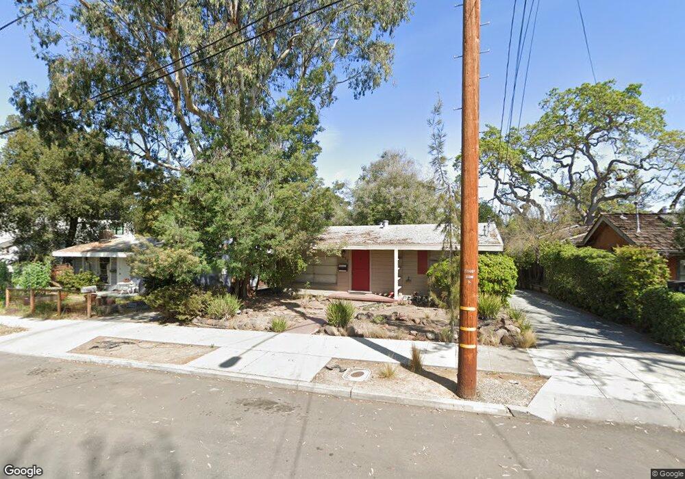
2057 Amherst St Unit 2057 2065 Palo Alto, CA 94306
Estimated Value: $1,672,000 - $3,253,000
4
Beds
2
Baths
693
Sq Ft
$3,537/Sq Ft
Est. Value
About This Home
This home is located at 2057 Amherst St Unit 2057 2065, Palo Alto, CA 94306 and is currently estimated at $2,451,068, approximately $3,536 per square foot. 2057 Amherst St Unit 2057 2065 is a home located in Santa Clara County with nearby schools including Escondido Elementary School, Frank S. Greene Jr. Middle, and Palo Alto High School.
Ownership History
Date
Name
Owned For
Owner Type
Purchase Details
Closed on
Nov 4, 2016
Sold by
Clark Joseph H
Bought by
Cato Investment Co Llc
Current Estimated Value
Purchase Details
Closed on
Oct 27, 2006
Sold by
Clark Anne P
Bought by
Clark Anne P and Clark David H
Create a Home Valuation Report for This Property
The Home Valuation Report is an in-depth analysis detailing your home's value as well as a comparison with similar homes in the area
Home Values in the Area
Average Home Value in this Area
Purchase History
| Date | Buyer | Sale Price | Title Company |
|---|---|---|---|
| Cato Investment Co Llc | $2,300,000 | Fidelity National Title Co | |
| Clark Anne P | -- | First American Title |
Source: Public Records
Tax History Compared to Growth
Tax History
| Year | Tax Paid | Tax Assessment Tax Assessment Total Assessment is a certain percentage of the fair market value that is determined by local assessors to be the total taxable value of land and additions on the property. | Land | Improvement |
|---|---|---|---|---|
| 2025 | $31,750 | $2,669,343 | $2,611,317 | $58,026 |
| 2024 | $31,750 | $2,617,004 | $2,560,115 | $56,889 |
| 2023 | $31,284 | $2,565,691 | $2,509,917 | $55,774 |
| 2022 | $30,923 | $2,515,384 | $2,460,703 | $54,681 |
| 2021 | $30,314 | $2,466,063 | $2,412,454 | $53,609 |
| 2020 | $29,688 | $2,440,778 | $2,387,718 | $53,060 |
| 2019 | $29,361 | $2,392,920 | $2,340,900 | $52,020 |
| 2018 | $28,554 | $2,346,000 | $2,295,000 | $51,000 |
| 2017 | $28,054 | $2,300,000 | $2,250,000 | $50,000 |
| 2016 | $2,036 | $97,974 | $43,909 | $54,065 |
| 2015 | $2,009 | $96,503 | $43,250 | $53,253 |
| 2014 | $1,871 | $94,613 | $42,403 | $52,210 |
Source: Public Records
Map
Nearby Homes
- 843 Sonoma Terrace
- 103 Peter Coutts Cir
- 12 Peter Coutts Cir
- 72 Peter Coutts Cir
- 78 Pearce Mitchell Place
- 410 Sheridan Ave Unit 227
- 410 Sheridan Ave Unit 446
- 1630 Portola Ave
- 5 Plan at Acacia
- 4X Plan at Acacia
- 4 Plan at Acacia
- 3 Plan at Acacia
- 2A Plan at Acacia
- 2 Plan at Acacia
- 1 Plan at Acacia
- 200 Sheridan Ave Unit 304
- 200 Sheridan Ave Unit 303
- 200 Sheridan Ave Unit 103
- 200 Sheridan Ave Unit 307
- 715 Matadero Ave
- 2057 Amherst St
- 2035 Amherst St
- 2081 Amherst St
- 2103 Amherst St
- 2015 Amherst St
- 1655 Stanford Ave
- 2121 Amherst St
- 2060 Amherst St
- 2040 Amherst St
- 2102 Bowdoin St
- 2030 Amherst St
- 2098 Amherst St
- 2110 Bowdoin St
- 2020 Amherst St
- 2131 Amherst St
- 2100 Amherst St
- 2120 Bowdoin St
- 2010 Amherst St
- 2000 Amherst St
- 2130 Bowdoin St