Estimated Value: $323,000 - $361,300
4
Beds
1
Bath
1,360
Sq Ft
$250/Sq Ft
Est. Value
About This Home
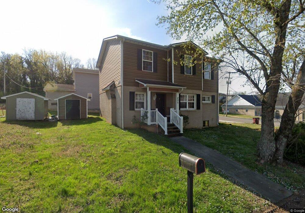
This home is located at 206 Bessie Harvey Ave, Alcoa, TN 37701 and is currently estimated at $339,575, approximately $249 per square foot. 206 Bessie Harvey Ave is a home located in Blount County with nearby schools including Alcoa Elementary School, Alcoa Middle School, and Alcoa High School.
Ownership History
Date
Name
Owned For
Owner Type
Purchase Details
Closed on
Dec 22, 2011
Sold by
Blount County Habitat For
Bought by
Poulus Koko and Souna Koko
Current Estimated Value
Home Financials for this Owner
Home Financials are based on the most recent Mortgage that was taken out on this home.
Original Mortgage
$30,159
Outstanding Balance
$20,690
Interest Rate
4.07%
Mortgage Type
Commercial
Estimated Equity
$318,885
Purchase Details
Closed on
Jun 9, 2010
Sold by
White Mary Ruth
Bought by
Blount County Habitat For Huma
Purchase Details
Closed on
Aug 7, 1962
Bought by
White George Martin
Create a Home Valuation Report for This Property
The Home Valuation Report is an in-depth analysis detailing your home's value as well as a comparison with similar homes in the area
Home Values in the Area
Average Home Value in this Area
Purchase History
| Date | Buyer | Sale Price | Title Company |
|---|---|---|---|
| Poulus Koko | $153,400 | -- | |
| Koko Poulus | $153,426 | -- | |
| Blount County Habitat For Huma | $30,000 | -- | |
| White George Martin | -- | -- |
Source: Public Records
Mortgage History
| Date | Status | Borrower | Loan Amount |
|---|---|---|---|
| Open | Koko Poulus | $30,159 | |
| Open | Koko Poulus | $124,979 | |
| Closed | White George Martin | $124,979 |
Source: Public Records
Tax History Compared to Growth
Tax History
| Year | Tax Paid | Tax Assessment Tax Assessment Total Assessment is a certain percentage of the fair market value that is determined by local assessors to be the total taxable value of land and additions on the property. | Land | Improvement |
|---|---|---|---|---|
| 2025 | -- | $80,975 | $0 | $0 |
| 2024 | $2,656 | $80,975 | $7,500 | $73,475 |
| 2023 | $2,656 | $80,975 | $7,500 | $73,475 |
| 2022 | $2,174 | $45,850 | $3,000 | $42,850 |
| 2021 | $2,174 | $45,850 | $3,000 | $42,850 |
| 2020 | $2,174 | $45,875 | $3,000 | $42,875 |
| 2019 | $2,174 | $45,875 | $3,000 | $42,875 |
| 2018 | $1,804 | $40,725 | $2,400 | $38,325 |
| 2017 | $1,804 | $40,725 | $2,400 | $38,325 |
| 2016 | $1,804 | $40,725 | $2,400 | $38,325 |
| 2015 | $1,674 | $40,725 | $2,400 | $38,325 |
| 2014 | $1,380 | $40,725 | $2,400 | $38,325 |
| 2013 | $1,380 | $33,575 | $0 | $0 |
Source: Public Records
Map
Nearby Homes
- 218 Burns St
- 1231 Jefferson Ave
- 124 Olympia Dr
- 1208 Madison Ave
- 1242 Jefferson Ave
- 1301 Jefferson Ave
- 1304 Jefferson Ave
- 250 S Rankin Rd
- 507 Rule St
- 412 Rule St
- 233 Olympia Dr
- 203 Mcginley St
- 239 Lindsay St
- 255 Sanderson St
- 106 Regal Tower
- 110 Regal Tower
- 111 Regal Tower
- 1217 Everett Ave
- 1406 Madison Ave
- 841 Sevierville Rd Unit 140
- 315 Andy Carr Ave
- 203 Bessie Harvey Ave
- 253 Andy Carr Ave
- 221 Bessie Harvey Ave
- 258 Andy Carr Ave
- 252 Andy Carr Ave
- 225 Bessie Harvey Ave
- 123 Bishop St
- 249 Andy Carr Ave
- 230 Bessie Harvey Ave
- 230 Bessie Harvey Ave
- 121 Bishop St
- 121 Bishop St
- 229 Bessie Harvey Ave
- 230 Besse Harvey
- 228 Bishop St
- 247 Andy Carr Ave
- 234 Bessie Harvey Ave
- 168 Bessie Harvey Ave
- 233 Bessie Harvey Ave