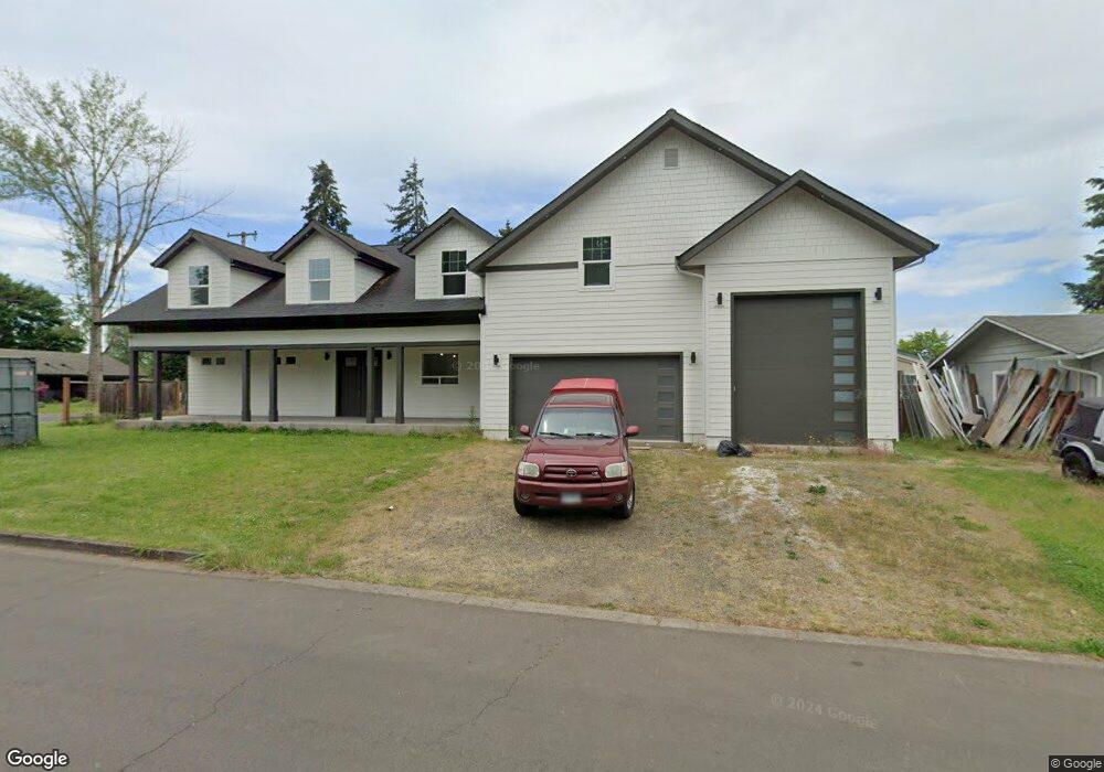
2060 Delta St Eugene, OR 97404
River Road NeighborhoodEstimated Value: $581,376 - $702,000
4
Beds
4
Baths
3,227
Sq Ft
$206/Sq Ft
Est. Value
About This Home
This home is located at 2060 Delta St, Eugene, OR 97404 and is currently estimated at $666,094, approximately $206 per square foot. 2060 Delta St is a home located in Lane County with nearby schools including Irving Elementary School, Shasta Middle School, and Willamette High School.
Ownership History
Date
Name
Owned For
Owner Type
Purchase Details
Closed on
Feb 6, 2002
Sold by
Spargo Patricia
Bought by
Ebert Shawn R
Current Estimated Value
Home Financials for this Owner
Home Financials are based on the most recent Mortgage that was taken out on this home.
Original Mortgage
$103,075
Outstanding Balance
$41,502
Interest Rate
7.13%
Estimated Equity
$624,592
Purchase Details
Closed on
Oct 1, 2001
Sold by
Spargo Robert
Bought by
Spargo Patricia
Create a Home Valuation Report for This Property
The Home Valuation Report is an in-depth analysis detailing your home's value as well as a comparison with similar homes in the area
Home Values in the Area
Average Home Value in this Area
Purchase History
| Date | Buyer | Sale Price | Title Company |
|---|---|---|---|
| Ebert Shawn R | $108,505 | American Title Group | |
| Spargo Patricia | -- | -- |
Source: Public Records
Mortgage History
| Date | Status | Borrower | Loan Amount |
|---|---|---|---|
| Open | Ebert Shawn R | $103,075 |
Source: Public Records
Tax History
| Year | Tax Paid | Tax Assessment Tax Assessment Total Assessment is a certain percentage of the fair market value that is determined by local assessors to be the total taxable value of land and additions on the property. | Land | Improvement |
|---|---|---|---|---|
| 2025 | $4,803 | $326,522 | -- | -- |
| 2024 | $4,680 | $317,012 | -- | -- |
| 2023 | $4,680 | $307,779 | $0 | $0 |
| 2022 | $4,056 | $277,295 | $0 | $0 |
| 2021 | $3,693 | $251,348 | $0 | $0 |
| 2020 | $3,578 | $244,028 | $0 | $0 |
| 2019 | $3,388 | $236,921 | $0 | $0 |
| 2018 | $3,110 | $211,867 | $0 | $0 |
| 2017 | $3,001 | $211,867 | $0 | $0 |
| 2016 | $2,630 | $185,578 | $0 | $0 |
| 2015 | $2,065 | $143,365 | $0 | $0 |
| 2014 | $2,084 | $139,189 | $0 | $0 |
Source: Public Records
Map
Nearby Homes
- 1307 Bramblewood Ln
- 1755 Brentwood Ave
- 2488 Northampton
- 1682 Hemlock St
- 541 Durham Ave
- 805 Impala Ave
- 2563 York St
- 1566 Maywood Ave
- 2580 Crowther Dr
- 2610 Crowther Dr
- 2721 La Darrah St
- 3906 Century Dr
- 303 Lenore Loop
- 401 Sterling Dr
- 3717 Riviera
- 3886 Aerial Way
- 2931 Shelby Way
- 2965 Teal Place
- 2439 Quince St
- 2987 Dry Creek Rd
Your Personal Tour Guide
Ask me questions while you tour the home.