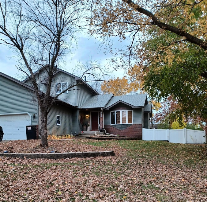


2065 Kings Rd Saint Paul, MN 55122
Estimated payment $3,066/month
Highlights
- Deck
- No HOA
- The kitchen features windows
- 2 Fireplaces
- Stainless Steel Appliances
- Porch
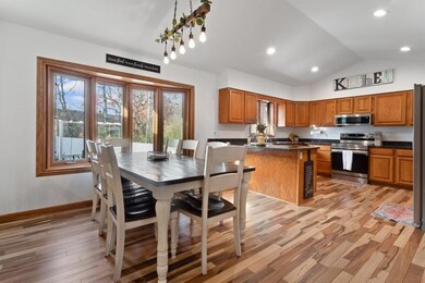
About This Home
Beautifully Updated Home Perfect for Entertaining! This stunning, one-of-a-kind home is full of custom touches and modern upgrades throughout. The inviting living area features a custom-built mantel and shelving surrounding a cozy fireplace, creating the perfect centerpiece for gatherings or quiet nights in. Enjoy two newly remodeled bathrooms featuring beautiful flooring and stylish finishes, adding both comfort and elegance. The home also includes a flex room that can easily serve as a third living area, home office, or fifth bedroom, offering endless versatility for your lifestyle. Recent updates include a new Samsung washer and dryer, new water softener, and a roof replaced in 2022, ensuring peace of mind for years to come. Step outside to a large, fenced-in backyard complete with durable vinyl fencing, a dedicated dog run, and a 20x12 hard-roof pergola—perfect for outdoor dining, relaxing, or entertaining guests. Gather around the built-in fire pit and enjoy evenings under the stars in your own private oasis. This home truly has it all—style, comfort, and space to entertain both indoors and out!
Home Details
Home Type
- Single Family
Est. Annual Taxes
- $3,280
Year Built
- Built in 1991
Lot Details
- 0.32 Acre Lot
- Lot Dimensions are 78x139x113x158
- Property is Fully Fenced
- Vinyl Fence
- Chain Link Fence
- Many Trees
Parking
- 3 Car Attached Garage
- Garage Door Opener
Home Design
- Metal Siding
- Vinyl Siding
Interior Spaces
- 2-Story Property
- 2 Fireplaces
- Free Standing Fireplace
- Electric Fireplace
- Gas Fireplace
- Family Room
- Living Room
- Dining Room
- Basement
- Block Basement Construction
Kitchen
- Cooktop
- Microwave
- Dishwasher
- Stainless Steel Appliances
- ENERGY STAR Qualified Appliances
- The kitchen features windows
Bedrooms and Bathrooms
- 4 Bedrooms
Laundry
- Laundry Room
- Dryer
- Washer
Outdoor Features
- Deck
- Porch
Utilities
- Forced Air Heating and Cooling System
- Vented Exhaust Fan
- Underground Utilities
- Gas Water Heater
- Water Softener is Owned
Community Details
- No Home Owners Association
- Vienna Woods Subdivision
Listing and Financial Details
- Assessor Parcel Number 108195004110
Map
Home Values in the Area
Average Home Value in this Area
Tax History
| Year | Tax Paid | Tax Assessment Tax Assessment Total Assessment is a certain percentage of the fair market value that is determined by local assessors to be the total taxable value of land and additions on the property. | Land | Improvement |
|---|---|---|---|---|
| 2024 | $3,280 | $487,100 | $112,200 | $374,900 |
| 2023 | $3,344 | $501,000 | $112,600 | $388,400 |
| 2022 | $5,230 | $466,500 | $112,300 | $354,200 |
| 2021 | $4,178 | $393,500 | $97,600 | $295,900 |
| 2020 | $4,120 | $374,900 | $93,000 | $281,900 |
| 2019 | $4,101 | $373,300 | $88,600 | $284,700 |
| 2018 | $3,860 | $356,600 | $84,400 | $272,200 |
| 2017 | $3,620 | $324,100 | $80,400 | $243,700 |
| 2016 | $3,626 | $304,200 | $76,500 | $227,700 |
| 2015 | $3,274 | $282,130 | $73,662 | $208,468 |
| 2014 | -- | $263,709 | $71,061 | $192,648 |
| 2013 | -- | $240,601 | $63,713 | $176,888 |
Property History
| Date | Event | Price | List to Sale | Price per Sq Ft |
|---|---|---|---|---|
| 11/17/2025 11/17/25 | For Sale | $529,995 | -- | $211 / Sq Ft |
Purchase History
| Date | Type | Sale Price | Title Company |
|---|---|---|---|
| Warranty Deed | $277,500 | -- |
Source: NorthstarMLS
MLS Number: 6815958
APN: 10-81950-04-110
Disclaimer: Certain information contained herein is derived from information provided by parties other than Homes.com. All information provided is deemed reliable, but is not guaranteed to be accurate and should be independently verified.
![]() Based on information submitted to the MLS GRID. All data is obtained from various sources and may not have been verified by broker or MLS GRID. Supplied Open House Information is subject to change without notice. All information should be independently reviewed and verified for accuracy. Properties may or may not be listed by the office/agent presenting the information. Some IDX listings have been excluded from this website.
Based on information submitted to the MLS GRID. All data is obtained from various sources and may not have been verified by broker or MLS GRID. Supplied Open House Information is subject to change without notice. All information should be independently reviewed and verified for accuracy. Properties may or may not be listed by the office/agent presenting the information. Some IDX listings have been excluded from this website.
The Digital Millennium Copyright Act of 1998, 17 U.S.C. § 512 (the “DMCA”) provides recourse for copyright owners who believe that material appearing on the Internet infringes their rights under U.S. copyright law. If you believe in good faith that any content or material made available in connection with our website or services infringes your copyright, you (or your agent) may send us a notice requesting that the content or material be removed, or access to it blocked.
Notices must be sent in writing by email to DMCAnotice@MLSGrid.com.
The DMCA requires that your notice of alleged copyright infringement include the following information:
(1) description of the copyrighted work that is the subject of claimed infringement;
(2) description of the alleged infringing content and information sufficient to permit us to locate the content;
(3) contact information for you, including your address, telephone number and email address;
(4) a statement by you that you have a good faith belief that the content in the manner complained of is not authorized by the copyright owner, or its agent, or by the operation of any law;
(5) a statement by you, signed under penalty of perjury, that the information in the notification is accurate and that you have the authority to enforce the copyrights that are claimed to be infringed; and
(6) a physical or electronic signature of the copyright owner or a person authorized to act on the copyright owner’s behalf. Failure to include all of the above information may result in the delay of the processing of your complaint.
- 2100 Viburnum Trail
- 2107 Kings Rd
- 2009 Vienna Ln
- 4774 Slater Rd
- 12068 Gantry Ln
- 2123 Cliffhill Ln
- 4632 Westwood Ln
- 12044 Gantry Ln
- 2115 Cliffview Dr
- 247 River Woods Ln
- 3309 Red Oak Cir N
- 221 River Woods Ln
- 319 River Woods Ln
- 1942 Grant Alcove Unit 65
- 4463 Cinnamon Ridge Cir
- 12197 Geneva Way
- 4682 Lenore Ln
- 1917 Jan Echo Trail
- 4397 Onyx Dr
- 4370 Nicols Rd
- 4507 Scott Trail
- 4598 Slater Rd
- 4488 Cinnamon Ridge Trail Unit B
- 4542 Villa Pkwy
- 4463 Cinnamon Ridge Cir
- 7405 W 123rd St
- 4415 Naper Bay
- 7126 123rd St W Unit 353
- 7440 Germane Trail Unit TOWNHOUSE end unit
- 7472 Germane Trail
- 12555 Pennock Ave
- 12685 Germane Ave
- 12655 Garner Way Unit 50
- 12596 Gavotte Ave Unit 98
- 2520 Allen Dr
- 7433 128th St W
- 12790 Germane Ave
- 4456 Johnny Cake Ridge Rd
- 1813 Trailway Dr
- 4182 Rahn Rd
