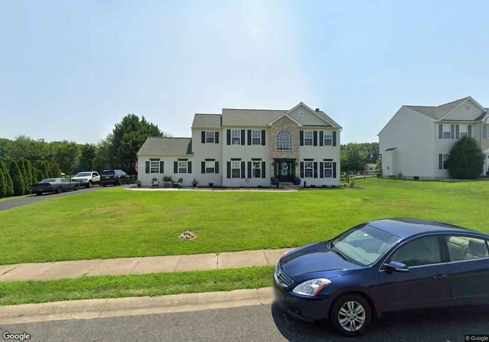
207 Olivine Cir Townsend, DE 19734
Estimated Value: $564,697 - $608,000
4
Beds
3
Baths
2,564
Sq Ft
$231/Sq Ft
Est. Value
About This Home
This home is located at 207 Olivine Cir, Townsend, DE 19734 and is currently estimated at $591,424, approximately $230 per square foot. 207 Olivine Cir is a home located in New Castle County with nearby schools including Old State Elementary School, Cantwell's Bridge Middle School, and Odessa High School.
Ownership History
Date
Name
Owned For
Owner Type
Purchase Details
Closed on
Oct 31, 2006
Sold by
Pinkett Gilbert and Pinkett Monica R
Bought by
Morrell Chris A and Morrell Katalin C
Current Estimated Value
Home Financials for this Owner
Home Financials are based on the most recent Mortgage that was taken out on this home.
Original Mortgage
$308,000
Outstanding Balance
$183,207
Interest Rate
6.31%
Mortgage Type
Purchase Money Mortgage
Estimated Equity
$408,217
Purchase Details
Closed on
Dec 30, 2002
Sold by
Benchmark Builders Inc
Bought by
Pinkett Gilbert and Pinkett Monica R
Home Financials for this Owner
Home Financials are based on the most recent Mortgage that was taken out on this home.
Original Mortgage
$210,300
Interest Rate
6.08%
Purchase Details
Closed on
Jun 26, 2002
Sold by
First State Enterprises Inc
Bought by
Benchmark Builders Inc
Create a Home Valuation Report for This Property
The Home Valuation Report is an in-depth analysis detailing your home's value as well as a comparison with similar homes in the area
Home Values in the Area
Average Home Value in this Area
Purchase History
| Date | Buyer | Sale Price | Title Company |
|---|---|---|---|
| Morrell Chris A | $385,000 | None Available | |
| Pinkett Gilbert | $221,370 | -- | |
| Benchmark Builders Inc | $45,000 | -- |
Source: Public Records
Mortgage History
| Date | Status | Borrower | Loan Amount |
|---|---|---|---|
| Open | Morrell Chris A | $308,000 | |
| Previous Owner | Pinkett Gilbert | $210,300 |
Source: Public Records
Tax History
| Year | Tax Paid | Tax Assessment Tax Assessment Total Assessment is a certain percentage of the fair market value that is determined by local assessors to be the total taxable value of land and additions on the property. | Land | Improvement |
|---|---|---|---|---|
| 2024 | $4,243 | $98,200 | $8,800 | $89,400 |
| 2023 | $3,628 | $98,200 | $8,800 | $89,400 |
| 2022 | $3,633 | $98,200 | $8,800 | $89,400 |
| 2021 | $3,587 | $98,200 | $8,800 | $89,400 |
| 2020 | $3,538 | $98,200 | $8,800 | $89,400 |
| 2019 | $3,721 | $98,200 | $8,800 | $89,400 |
| 2018 | $3,175 | $98,200 | $8,800 | $89,400 |
| 2017 | $2,896 | $93,400 | $8,800 | $84,600 |
| 2016 | $2,639 | $93,400 | $8,800 | $84,600 |
| 2015 | $2,571 | $93,400 | $8,800 | $84,600 |
| 2014 | $2,569 | $93,400 | $8,800 | $84,600 |
Source: Public Records
Map
Nearby Homes
- 3 Mica St
- 27 Basalt St
- 1143 Kayla Ln
- 1019 Robinson Rd
- 520 Chestnut Ln
- 1020 Robinson Rd
- 1027 Robinson Rd
- TBD 3363 Harris Rd
- 413 Janets Way
- 1065 Robinson Rd Unit WHITFIELD RANCH PLAN
- 1063 Robinson Rd Unit WHITFIELD PLAN
- 1069 Robinson Rd Unit PEMBROOK PLAN
- 1067 Robinson Rd Unit LAKELAND PLAN
- 1071 Robinson Rd Unit DELRAY PLAN
- 433 Wyatt Dr
- 101 Wedge Ct
- 212 Case Rd
- 195 Case Rd
- 208 Case Rd
- 206 Case Rd