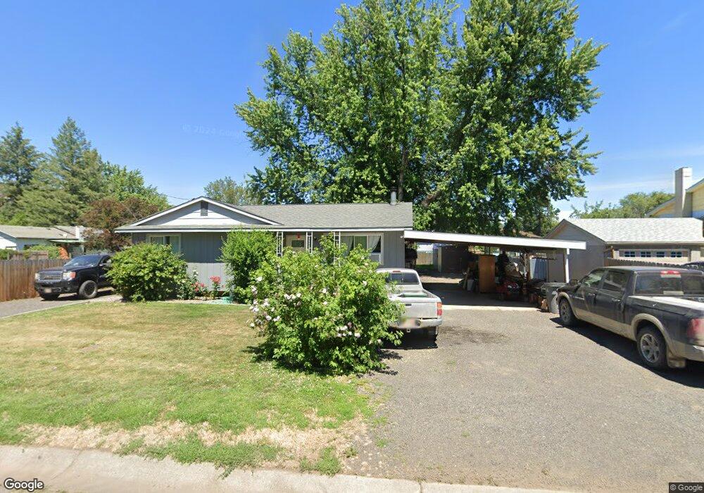
207 W Birch Ave Lapwai, ID 83540
Estimated Value: $219,000 - $627,000
3
Beds
1
Bath
1,006
Sq Ft
$337/Sq Ft
Est. Value
About This Home
This home is located at 207 W Birch Ave, Lapwai, ID 83540 and is currently estimated at $338,580, approximately $336 per square foot. 207 W Birch Ave is a home with nearby schools including Lapwai Elementary School and Lapwai Middle/High School.
Ownership History
Date
Name
Owned For
Owner Type
Purchase Details
Closed on
Aug 29, 2022
Sold by
Larry Larry Boyer Land & Cattle and Larry Boyer Land & Cattle
Bought by
Central Idaho Land Llc
Current Estimated Value
Purchase Details
Closed on
Aug 14, 2007
Sold by
Wilson Marsha D and Wilson Marsha Dee
Bought by
Wilson Heath E and Wilson Amy J
Home Financials for this Owner
Home Financials are based on the most recent Mortgage that was taken out on this home.
Original Mortgage
$60,000
Interest Rate
6.62%
Mortgage Type
Unknown
Create a Home Valuation Report for This Property
The Home Valuation Report is an in-depth analysis detailing your home's value as well as a comparison with similar homes in the area
Home Values in the Area
Average Home Value in this Area
Purchase History
| Date | Buyer | Sale Price | Title Company |
|---|---|---|---|
| Central Idaho Land Llc | -- | None Listed On Document | |
| Wilson Heath E | -- | -- |
Source: Public Records
Mortgage History
| Date | Status | Borrower | Loan Amount |
|---|---|---|---|
| Previous Owner | Wilson Heath E | $60,000 |
Source: Public Records
Tax History Compared to Growth
Tax History
| Year | Tax Paid | Tax Assessment Tax Assessment Total Assessment is a certain percentage of the fair market value that is determined by local assessors to be the total taxable value of land and additions on the property. | Land | Improvement |
|---|---|---|---|---|
| 2025 | $987 | $132,766 | $24,750 | $108,016 |
| 2024 | $8 | $125,912 | $26,250 | $99,662 |
| 2023 | $696 | $113,839 | $21,500 | $92,339 |
| 2022 | $962 | $108,835 | $18,750 | $90,085 |
| 2021 | $918 | $91,526 | $16,000 | $75,526 |
| 2020 | $921 | $86,863 | $13,100 | $73,763 |
| 2019 | $898 | $86,863 | $13,100 | $73,763 |
| 2018 | $857 | $84,233 | $13,100 | $71,133 |
| 2017 | $939 | $0 | $0 | $0 |
| 2016 | $939 | $0 | $0 | $0 |
| 2015 | $914 | $0 | $0 | $0 |
| 2014 | $896 | $88,533 | $13,325 | $75,208 |
Source: Public Records
Map
Nearby Homes
- 188 Coyote Dr
- TBD Highway 12
- 2111 Vinifera Blvd
- 2108 Vinifera Blvd
- 7774 Paddock Ln
- 2244 Park Ave
- 2243 Powers Dr
- 2235 Powers Dr
- 22236 Gunsmoke Canyon
- 2219 Powers Dr
- 2213 Powers Dr
- TBD Cougar Ridge Rd
- 2211 Powers Dr
- TBD Clearwater Dr
- 3714 Skyview Dr
- 3728 Skyview Dr
- NKA Clearwater Ridge Dr
- 0 Nka Clearwater Ridge Dr
- 1248 Bighorn Dr
- 2206 Ripon Ave
- 156 Joseph St W
- 154 Joseph St W
- 150 Joseph Ct
- 201 Birch Ave W
- 152 Joseph Ct
- 111 S 2nd St W
- 116 1st St W
- 153 Joseph St W
- 151 Joseph St W
- 142 Joseph Ct
- 146 Joseph Ct
- 203 W Alder St
- 215 W Alder St
- 108 Joseph St E
- 103 Joseph St E
- XX Bare Land
- 145 Joseph St W
- 114 Looking Glass Ct
- 204 W Alder St
- 112 Looking Glass Ct