
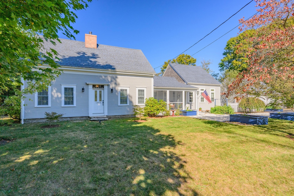
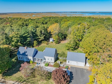
2070 Main St West Barnstable, MA 02668
West Barnstable NeighborhoodEstimated payment $7,028/month
Total Views
5,283
4
Beds
3
Baths
2,462
Sq Ft
$485
Price per Sq Ft
Highlights
- Property is near a marina
- Deck
- Cathedral Ceiling
- Medical Services
- Wooded Lot
- Wood Flooring
About This Home
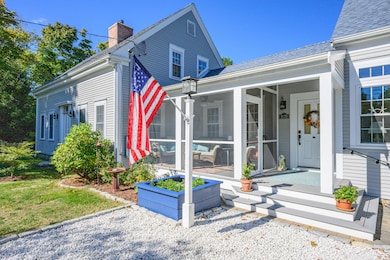
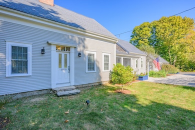
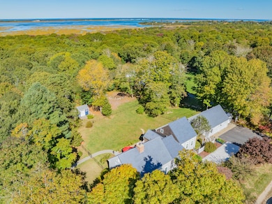
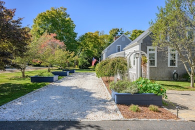
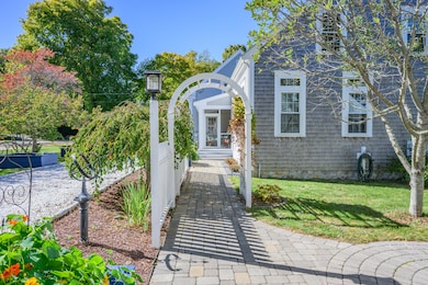
Welcome to the Loring Homestead, a lovingly restored 1800's farmhouse that harkens back to Cape Cod's shellfishing heritage. Conveniently located close to Barnstable & West Barnstable's villages, the scenic northside beaches of Sandy Neck & Millway, and all Mid Cape amenities. Completely renovated in 2014 while retaining its original charm & expanded with a new guest wing in 2018, this charming, custom, light-filled home on 1.59 acres offers the new owners, a move-in ready gentleman's farm with limitless possibilities. The heart of the home is the open kitchen/dining room with beautiful cabinetry, large island & quartzite countertops which flows seamlessly into the inviting front to back living room with warm wood floors, beams, a wood-burning fireplace, built-ins & oversized windows to take in the pastoral views. Retire upstairs to the primary suite and second bedroom & bath. The new east wing offers a first floor primary suite, home office up (4th bdrm) & stunning 2 story family room with wet bar/servery. Storage abounds in the oversized 2 car garage, walk-out basement & sheds. A sunny screened porch, private sitting deck, large patio & fire pit invite enjoyment of the grounds
Home Details
Home Type
- Single Family
Est. Annual Taxes
- $8,614
Year Built
- Built in 1800 | Remodeled
Lot Details
- 1.59 Acre Lot
- Lot Dimensions are 329.87 x 214.91
- Level Lot
- Wooded Lot
- Garden
Parking
- 2 Car Garage
- Open Parking
Home Design
- Stone Foundation
- Poured Concrete
- Pitched Roof
- Asphalt Roof
- Shingle Siding
- Clapboard
Interior Spaces
- 2,462 Sq Ft Home
- 2-Story Property
- Wet Bar
- Built-In Features
- Beamed Ceilings
- Cathedral Ceiling
- Wood Burning Fireplace
- Bay Window
- French Doors
- Living Room
- Dining Room
- Screened Porch
Kitchen
- Breakfast Bar
- Gas Range
- Dishwasher
- Kitchen Island
Flooring
- Wood
- Carpet
- Tile
Bedrooms and Bathrooms
- 4 Bedrooms
- Primary Bedroom on Main
- Cedar Closet
- Linen Closet
- Walk-In Closet
- 3 Full Bathrooms
Laundry
- Laundry Room
- Laundry on main level
- Washer
Basement
- Partial Basement
- Interior Basement Entry
Outdoor Features
- Property is near a marina
- Deck
- Patio
- Outbuilding
Location
- Property is near shops
Utilities
- Central Air
- Heating Available
- Gas Water Heater
- Septic Tank
- Private Sewer
Listing and Financial Details
- Assessor Parcel Number BARN M:217 L:025
Community Details
Recreation
- Tennis Courts
Additional Features
- No Home Owners Association
- Medical Services
Map
Create a Home Valuation Report for This Property
The Home Valuation Report is an in-depth analysis detailing your home's value as well as a comparison with similar homes in the area
Home Values in the Area
Average Home Value in this Area
Tax History
| Year | Tax Paid | Tax Assessment Tax Assessment Total Assessment is a certain percentage of the fair market value that is determined by local assessors to be the total taxable value of land and additions on the property. | Land | Improvement |
|---|---|---|---|---|
| 2025 | $8,614 | $932,300 | $212,500 | $719,800 |
| 2024 | $8,198 | $935,900 | $212,500 | $723,400 |
| 2023 | $7,470 | $831,800 | $210,900 | $620,900 |
| 2022 | $7,505 | $672,500 | $152,600 | $519,900 |
| 2021 | $6,891 | $588,500 | $152,600 | $435,900 |
| 2020 | $7,220 | $588,900 | $158,500 | $430,400 |
| 2019 | $5,031 | $411,700 | $158,500 | $253,200 |
| 2018 | $4,738 | $376,600 | $173,800 | $202,800 |
| 2017 | $4,681 | $374,500 | $173,800 | $200,700 |
| 2016 | $4,225 | $342,700 | $173,500 | $169,200 |
| 2015 | $4,270 | $352,600 | $166,600 | $186,000 |
Source: Public Records
Property History
| Date | Event | Price | List to Sale | Price per Sq Ft |
|---|---|---|---|---|
| 10/29/2025 10/29/25 | Pending | -- | -- | -- |
| 10/21/2025 10/21/25 | For Sale | $1,195,000 | -- | $485 / Sq Ft |
Source: Cape Cod & Islands Association of REALTORS®
Purchase History
| Date | Type | Sale Price | Title Company |
|---|---|---|---|
| Not Resolvable | $363,000 | -- | |
| Not Resolvable | $363,000 | -- | |
| Deed | -- | -- |
Source: Public Records
Mortgage History
| Date | Status | Loan Amount | Loan Type |
|---|---|---|---|
| Open | $290,400 | New Conventional | |
| Closed | $290,400 | New Conventional |
Source: Public Records
About the Listing Agent
She is an experienced Cape Cod Real Estate Agent with the local real estate market knowledge of someone who grew up on Cape Cod, has seen the world, and like many, has returned home to the Cape to stay! A graduate of Barnstable High School, Bates College, and Georgetown University, she has an undergraduate degree in Spanish and graduate degrees in Business Administration and Public Policy.
She has years of international banking experience working in the Latin American Divisions of Bank
Tara's Other Listings
Source: Cape Cod & Islands Association of REALTORS®
MLS Number: 22505289
APN: BARN-000217-000000-000025
Disclaimer: Certain information contained herein is derived from information provided by parties other than Homes.com. All information provided is deemed reliable, but is not guaranteed to be accurate and should be independently verified.
![]() All data relating to real estate for sale on this page comes from the Broker Reciprocity (BR) of the Cape Cod & Islands Multiple Listing Service, Inc. Detailed information about real estate listings held by brokerage firms other than CC&I Assoc. of REALTORS®, Inc. includes the name of the listing company. Neither the listing company nor CC&I Assoc. of REALTORS®, Inc. shall be responsible for any typographical errors, misinformation, misprints and shall be held totally harmless. The Broker providing this data believes it to be correct, but advises interested parties to confirm any item before relying on it in a purchase decision. All properties are subject to prior sale, changes, or withdrawal. Copyright 2025 © Cape Cod & Islands Multiple Listing Service, Inc. All rights reserved.
All data relating to real estate for sale on this page comes from the Broker Reciprocity (BR) of the Cape Cod & Islands Multiple Listing Service, Inc. Detailed information about real estate listings held by brokerage firms other than CC&I Assoc. of REALTORS®, Inc. includes the name of the listing company. Neither the listing company nor CC&I Assoc. of REALTORS®, Inc. shall be responsible for any typographical errors, misinformation, misprints and shall be held totally harmless. The Broker providing this data believes it to be correct, but advises interested parties to confirm any item before relying on it in a purchase decision. All properties are subject to prior sale, changes, or withdrawal. Copyright 2025 © Cape Cod & Islands Multiple Listing Service, Inc. All rights reserved.
Nearby Homes
- 1825 Main St
- 2181 Service Rd
- 350 & 360 Plum St
- 350 Plum St
- 29 Summerwind Ln
- 11 Shepherds Way
- 2656 Main St
- 22 Cranberry Ln
- 282 Parker Rd
- 93 Harris Meadow Ln
- 210 Attucks Ln
- 230 Attucks Ln
- 66 Tern Ln
- 40 Appaloosa Way
- 73 Tern Ln
- 62 Three Ponds Dr
- 0 Phinneys Ln
- 0 Indian Trail
- 2400 Meetinghouse Way
- 49 Lakeside Dr E