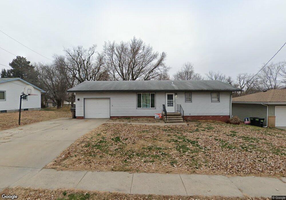
208 Fletcher St Sidney, IA 51652
Estimated Value: $126,000 - $178,000
3
Beds
2
Baths
1,040
Sq Ft
$142/Sq Ft
Est. Value
About This Home
This home is located at 208 Fletcher St, Sidney, IA 51652 and is currently estimated at $147,745, approximately $142 per square foot. 208 Fletcher St is a home located in Fremont County with nearby schools including Sidney Elementary School, Sidney High School, and Victory Christian School.
Ownership History
Date
Name
Owned For
Owner Type
Purchase Details
Closed on
Dec 10, 2020
Sold by
Wilson Anthony S and Wilson Bridgette W
Bought by
Tri-Valley Bank
Current Estimated Value
Home Financials for this Owner
Home Financials are based on the most recent Mortgage that was taken out on this home.
Original Mortgage
$75,000
Outstanding Balance
$66,891
Interest Rate
2.8%
Mortgage Type
New Conventional
Estimated Equity
$80,854
Purchase Details
Closed on
Dec 9, 2020
Sold by
Clifford Greedy Dale
Bought by
Wilson Anthony S and Wilson Bridgette E
Home Financials for this Owner
Home Financials are based on the most recent Mortgage that was taken out on this home.
Original Mortgage
$75,000
Outstanding Balance
$66,891
Interest Rate
2.8%
Mortgage Type
New Conventional
Estimated Equity
$80,854
Create a Home Valuation Report for This Property
The Home Valuation Report is an in-depth analysis detailing your home's value as well as a comparison with similar homes in the area
Purchase History
| Date | Buyer | Sale Price | Title Company |
|---|---|---|---|
| Tri-Valley Bank | -- | None Listed On Document | |
| Wilson Anthony S | $77,500 | Kocourek John W | |
| Wilson Anthony S | $77,500 | None Listed On Document |
Source: Public Records
Mortgage History
| Date | Status | Borrower | Loan Amount |
|---|---|---|---|
| Open | Tri-Valley Bank | $75,000 | |
| Closed | Wilson Anthony S | $75,000 |
Source: Public Records
Tax History
| Year | Tax Paid | Tax Assessment Tax Assessment Total Assessment is a certain percentage of the fair market value that is determined by local assessors to be the total taxable value of land and additions on the property. | Land | Improvement |
|---|---|---|---|---|
| 2025 | $2,502 | $124,910 | $11,930 | $112,980 |
| 2024 | $2,502 | $108,600 | $11,930 | $96,670 |
| 2023 | $2,632 | $108,600 | $11,930 | $96,670 |
| 2022 | $2,562 | $105,340 | $7,220 | $98,120 |
| 2021 | $2,562 | $98,260 | $6,740 | $91,520 |
| 2020 | $2,114 | $93,440 | $6,740 | $86,700 |
| 2019 | $2,264 | $94,080 | $0 | $0 |
| 2018 | $2,190 | $94,080 | $0 | $0 |
| 2017 | $2,190 | $84,750 | $0 | $0 |
| 2016 | $1,906 | $80,470 | $0 | $0 |
| 2015 | $1,906 | $80,470 | $0 | $0 |
| 2014 | $1,924 | $80,470 | $0 | $0 |
Source: Public Records
Map
Nearby Homes
- 205 Fletcher St
- 906 Park Dr
- 102 Wilson
- 100 Wilson
- 900 Maple St
- 310 Filmore St
- 0 City Building Listed By the Glasgow Fami Unit Lots
- 207 Cass St
- 610 East St
- 401 Filmore St
- 1110 Filmore St
- Tbd Main St
- 602 Rupp Rd Unit LotWP001
- 305 Main St
- 00 270th Ave
- 2244 270th Ave
- 0 275 Unit 6322810
- 2505 Knox Rd
- 2048 Horse Creek Rd
- 2290 Bluff Rd
Your Personal Tour Guide
Ask me questions while you tour the home.