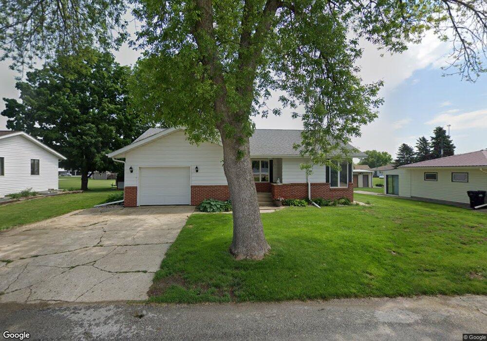
208 Westgate Ave Anthon, IA 51004
Estimated Value: $143,000 - $212,506
3
Beds
6
Baths
1,285
Sq Ft
$145/Sq Ft
Est. Value
About This Home
This home is located at 208 Westgate Ave, Anthon, IA 51004 and is currently estimated at $186,877, approximately $145 per square foot. 208 Westgate Ave is a home located in Woodbury County with nearby schools including Anthon Elementary School, Mvao Middle School, and Maple Valley-Anthon Oto High School.
Ownership History
Date
Name
Owned For
Owner Type
Purchase Details
Closed on
Dec 11, 2023
Sold by
Dose Whitney Inez
Bought by
Brandt Duane Darwin and Brandt Anita Leigh
Current Estimated Value
Home Financials for this Owner
Home Financials are based on the most recent Mortgage that was taken out on this home.
Original Mortgage
$136,000
Outstanding Balance
$133,849
Interest Rate
7.75%
Mortgage Type
New Conventional
Estimated Equity
$53,028
Purchase Details
Closed on
Oct 13, 2009
Sold by
Heinse Kevin W and Heinse Diane M
Bought by
Wolf Emmet and Wolf Mary Lu
Home Financials for this Owner
Home Financials are based on the most recent Mortgage that was taken out on this home.
Original Mortgage
$60,000
Interest Rate
5.5%
Mortgage Type
Adjustable Rate Mortgage/ARM
Purchase Details
Closed on
Jun 16, 2009
Sold by
Estate Of Wilam E Heinse
Bought by
Heinse Kevin W
Create a Home Valuation Report for This Property
The Home Valuation Report is an in-depth analysis detailing your home's value as well as a comparison with similar homes in the area
Home Values in the Area
Average Home Value in this Area
Purchase History
| Date | Buyer | Sale Price | Title Company |
|---|---|---|---|
| Brandt Duane Darwin | $170,000 | None Listed On Document | |
| Wolf Emmet | $82,500 | -- | |
| Heinse Kevin W | -- | None Available |
Source: Public Records
Mortgage History
| Date | Status | Borrower | Loan Amount |
|---|---|---|---|
| Open | Brandt Duane Darwin | $136,000 | |
| Previous Owner | Wolf Emmet | $60,000 |
Source: Public Records
Tax History Compared to Growth
Tax History
| Year | Tax Paid | Tax Assessment Tax Assessment Total Assessment is a certain percentage of the fair market value that is determined by local assessors to be the total taxable value of land and additions on the property. | Land | Improvement |
|---|---|---|---|---|
| 2025 | $2,270 | $172,710 | $9,090 | $163,620 |
| 2024 | $2,270 | $172,130 | $9,090 | $163,040 |
| 2023 | $2,098 | $172,130 | $9,090 | $163,040 |
| 2022 | $2,048 | $132,860 | $9,090 | $123,770 |
| 2021 | $2,048 | $132,860 | $9,090 | $123,770 |
| 2020 | $1,670 | $119,900 | $9,730 | $110,170 |
| 2019 | $1,578 | $96,490 | $9,730 | $86,760 |
| 2018 | $1,560 | $96,490 | $9,730 | $86,760 |
| 2017 | $1,586 | $96,490 | $9,730 | $86,760 |
| 2016 | $1,544 | $96,490 | $0 | $0 |
| 2015 | $1,604 | $90,170 | $9,090 | $81,080 |
| 2014 | $1,582 | $90,170 | $9,090 | $81,080 |
Source: Public Records
Map
Nearby Homes
- 300 Westgate Rd
- 206 Westgate Ave
- 106 Westgate Rd
- 207 Westgate Rd
- 207 Westgate Ave
- 301 Westgate Rd
- 205 Westgate Ave
- 303 Westgate Rd
- 304 Westgate Rd
- 104 Westgate Rd
- 501 W Division St
- 115 Westgate Rd
- 305 Westgate Rd
- 405 W Division St
- 109 Westgate Rd
- 111 Westgate Rd
- 107 Westgate Rd
- 102 Westgate Rd
- 403 W Division St
- 105 Westgate Rd