Estimated Value: $95,000 - $147,000
3
Beds
2
Baths
1,292
Sq Ft
$90/Sq Ft
Est. Value
About This Home
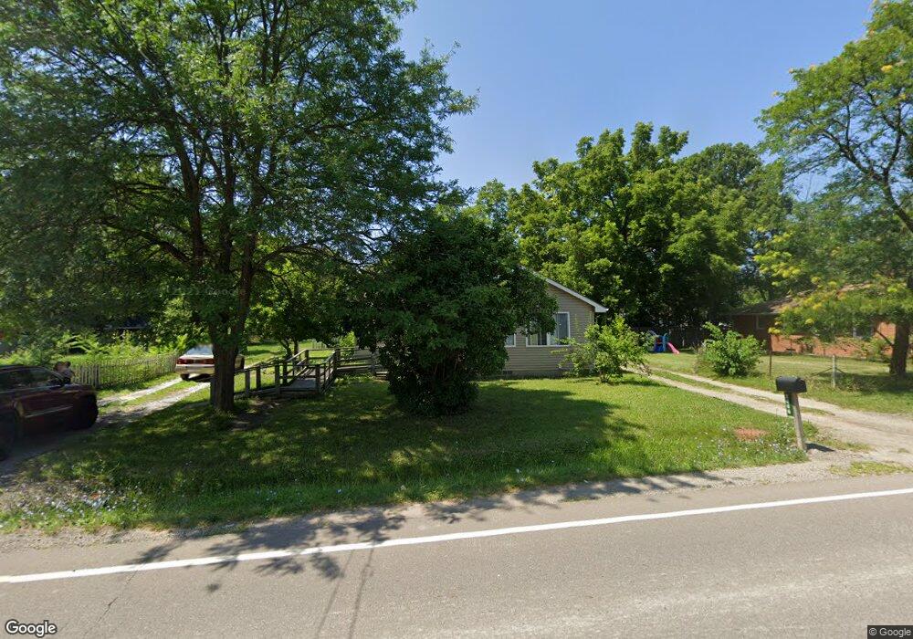
This home is located at 2086 S Graham Rd, Flint, MI 48532 and is currently estimated at $116,203, approximately $89 per square foot. 2086 S Graham Rd is a home located in Genesee County with nearby schools including Carman-Ainsworth High School, Genesee STEM Academy, and St. Paul Lutheran School.
Ownership History
Date
Name
Owned For
Owner Type
Purchase Details
Closed on
Feb 27, 2014
Sold by
Thompson Danny M
Bought by
Scoville David C
Current Estimated Value
Purchase Details
Closed on
Aug 4, 2010
Sold by
Scoville David Claude
Bought by
Thompson Danny M
Home Financials for this Owner
Home Financials are based on the most recent Mortgage that was taken out on this home.
Original Mortgage
$35,000
Interest Rate
4.32%
Mortgage Type
Seller Take Back
Purchase Details
Closed on
Mar 26, 2007
Sold by
Childers Elaine J
Bought by
Scoville David C
Purchase Details
Closed on
Jan 30, 2001
Sold by
Alaska Seaboard Partners Ltd Partnership
Bought by
Childers Elaine J
Purchase Details
Closed on
Sep 20, 2000
Sold by
Bennett Jerry W and Bennett Jannine R
Bought by
Del Norte Refi Llc
Create a Home Valuation Report for This Property
The Home Valuation Report is an in-depth analysis detailing your home's value as well as a comparison with similar homes in the area
Home Values in the Area
Average Home Value in this Area
Purchase History
| Date | Buyer | Sale Price | Title Company |
|---|---|---|---|
| Scoville David C | -- | None Available | |
| Thompson Danny M | $40,000 | Sargents Title Company | |
| Scoville David C | $50,000 | Lawyers Title | |
| Childers Elaine J | $44,900 | Centennial Title & Abstract | |
| Del Norte Refi Llc | $67,578 | -- |
Source: Public Records
Mortgage History
| Date | Status | Borrower | Loan Amount |
|---|---|---|---|
| Previous Owner | Thompson Danny M | $35,000 |
Source: Public Records
Tax History Compared to Growth
Tax History
| Year | Tax Paid | Tax Assessment Tax Assessment Total Assessment is a certain percentage of the fair market value that is determined by local assessors to be the total taxable value of land and additions on the property. | Land | Improvement |
|---|---|---|---|---|
| 2025 | $1,955 | $32,200 | $0 | $0 |
| 2024 | $1,242 | $27,000 | $0 | $0 |
| 2023 | $1,070 | $25,200 | $0 | $0 |
| 2022 | $955 | $19,600 | $0 | $0 |
| 2021 | $468 | $17,400 | $0 | $0 |
| 2020 | $616 | $16,300 | $0 | $0 |
| 2019 | $608 | $15,100 | $0 | $0 |
| 2018 | $1,044 | $15,700 | $0 | $0 |
| 2017 | $1,024 | $15,700 | $0 | $0 |
| 2016 | $1,039 | $15,700 | $0 | $0 |
| 2015 | $848 | $14,800 | $0 | $0 |
| 2014 | $346 | $14,500 | $0 | $0 |
| 2012 | -- | $17,900 | $17,900 | $0 |
Source: Public Records
Map
Nearby Homes
- 1540 Pound Dr
- 3277 Whitney Ave
- 3321 Hogarth Ave
- 18.41 Taft Rd
- VL Clairmont St
- 1600 Houran St
- 1574 Houran St
- 2468 Ketzler Dr
- 10 Acres T A Mansour Blvd
- 2470 Tandy Dr
- 2496 Ketzler Dr
- 1260 Gilbert St
- 3320 Timberview St
- 3918 Larchmont St
- 3493 Ridgecliffe Dr
- 959 Tacken St
- 3011 Curtis Dr
- 3801 Augusta St
- 3288 Tall Oaks Ct
- 3813 Larchmont St