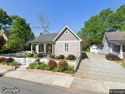
209 Locust St NW Marietta, GA 30064
Polk NeighborhoodEstimated Value: $770,000 - $825,000
3
Beds
3
Baths
1,952
Sq Ft
$410/Sq Ft
Est. Value
About This Home
This home is located at 209 Locust St NW, Marietta, GA 30064 and is currently estimated at $800,093, approximately $409 per square foot. 209 Locust St NW is a home located in Cobb County with nearby schools including West Side Elementary School, Marietta Sixth Grade Academy, and Marietta Middle School.
Ownership History
Date
Name
Owned For
Owner Type
Purchase Details
Closed on
Jul 12, 2018
Sold by
Bittinger Kenneth R
Bought by
Kenneth R
Current Estimated Value
Purchase Details
Closed on
Dec 29, 2015
Sold by
Batayias Peter K
Bought by
Bittinger Kenneth R and Bittinger Sharon K
Purchase Details
Closed on
Feb 11, 2015
Sold by
Raper Susan
Bought by
Batayias Pater K and 209 Locust Trust
Purchase Details
Closed on
Aug 28, 2014
Sold by
Jenkins Alonzo W
Bought by
Raper Susan
Create a Home Valuation Report for This Property
The Home Valuation Report is an in-depth analysis detailing your home's value as well as a comparison with similar homes in the area
Home Values in the Area
Average Home Value in this Area
Purchase History
| Date | Buyer | Sale Price | Title Company |
|---|---|---|---|
| Kenneth R | -- | -- | |
| Bittinger Kenneth R | $460,000 | -- | |
| Batayias Pater K | $125,000 | -- | |
| Raper Susan | $101,254 | -- |
Source: Public Records
Mortgage History
| Date | Status | Borrower | Loan Amount |
|---|---|---|---|
| Previous Owner | Jenkins Alonzo W | $122,750 |
Source: Public Records
Tax History Compared to Growth
Tax History
| Year | Tax Paid | Tax Assessment Tax Assessment Total Assessment is a certain percentage of the fair market value that is determined by local assessors to be the total taxable value of land and additions on the property. | Land | Improvement |
|---|---|---|---|---|
| 2024 | $258 | $237,492 | $80,000 | $157,492 |
| 2023 | $106 | $247,844 | $80,000 | $167,844 |
| 2022 | $258 | $247,844 | $80,000 | $167,844 |
| 2021 | $286 | $215,848 | $80,000 | $135,848 |
| 2020 | $284 | $198,080 | $80,000 | $118,080 |
| 2019 | $284 | $198,080 | $80,000 | $118,080 |
| 2018 | $281 | $176,188 | $68,000 | $108,188 |
| 2017 | $228 | $167,740 | $36,000 | $131,740 |
| 2016 | $242 | $167,740 | $36,000 | $131,740 |
| 2015 | $304 | $40,480 | $17,040 | $23,440 |
| 2014 | $589 | $76,056 | $0 | $0 |
Source: Public Records
Map
Nearby Homes
- 194 Locust St NW
- 285 Kennesaw Ave NW
- 281 Cherokee St NE
- 176 Stewart Ave NW
- 30 Sessions St NW
- 125 Sidney St
- 174 Sidney St
- 95 Whitlock Ave SW
- 255 Maple Ave NW
- 257 Vance Cir NE
- 196 Montgomery St NE
- 325 Polk St NW
- 452 Cherokee St NE
- 232 Hunt St NE
- 161 Blair Valley Dr NE
- 127 Atlanta St SE
- 167 Freyer Dr NE
- 423 Hunt St NE
- 425 Hunt St NE
- 209 Locust St NW
- 213 Locust St NW
- 201 Locust St NW
- 219 Locust St NW
- 68 Moon St NW Unit 68
- 68 Moon St NW
- 68 Moon St NW Unit 1
- 74 Moon St NW
- 195 Locust St NW
- 202 Locust St NW
- 76 Moon St NW
- 187 Locust St NW
- 71 Moon St NW
- 234 Locust St NW
- 82 Moon St NW
- 180 Locust St NW
- 75 Moon St NW
- 53 Maple Ave NW
- 86 Moon St NW
- 0 Moon St NW