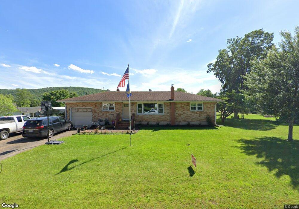
209 N Mccune Pilot Knob, MO 63663
Estimated Value: $177,000 - $253,000
3
Beds
2
Baths
1,824
Sq Ft
$112/Sq Ft
Est. Value
About This Home
This home is located at 209 N Mccune, Pilot Knob, MO 63663 and is currently estimated at $205,002, approximately $112 per square foot. 209 N Mccune is a home located in Iron County with nearby schools including Arcadia Valley Elementary School, Arcadia Valley Middle School, and Arcadia Valley High School.
Ownership History
Date
Name
Owned For
Owner Type
Purchase Details
Closed on
Apr 30, 2013
Sold by
Price Tammy Faye
Bought by
Schnedler Robert Michael and Megan Lea
Current Estimated Value
Purchase Details
Closed on
May 13, 2008
Sold by
Herod Michael James and Tammy Faye
Bought by
Price Tammy Faye
Purchase Details
Closed on
Nov 21, 2007
Sold by
Us Bank Na
Bought by
Herod Michael James and Tammy Faye
Purchase Details
Closed on
Jan 17, 2007
Sold by
Golden John W and Golden Vickie S
Bought by
Us Bank Na
Purchase Details
Closed on
Nov 1, 2004
Bought by
Golden John W and Golden Vickie S
Create a Home Valuation Report for This Property
The Home Valuation Report is an in-depth analysis detailing your home's value as well as a comparison with similar homes in the area
Purchase History
| Date | Buyer | Sale Price | Title Company |
|---|---|---|---|
| Schnedler Robert Michael | -- | -- | |
| Price Tammy Faye | -- | -- | |
| Herod Michael James | -- | -- | |
| Us Bank Na | $93,200 | -- | |
| Golden John W | -- | -- |
Source: Public Records
Tax History
| Year | Tax Paid | Tax Assessment Tax Assessment Total Assessment is a certain percentage of the fair market value that is determined by local assessors to be the total taxable value of land and additions on the property. | Land | Improvement |
|---|---|---|---|---|
| 2024 | $929 | $19,480 | $5,620 | $13,860 |
| 2023 | $910 | $19,480 | $5,620 | $13,860 |
| 2022 | $877 | $18,790 | $4,930 | $13,860 |
| 2021 | $863 | $18,790 | $4,930 | $13,860 |
| 2020 | $804 | $17,210 | $4,930 | $12,280 |
| 2019 | $804 | $17,210 | $4,930 | $12,280 |
| 2018 | $804 | $17,210 | $4,930 | $12,280 |
| 2017 | $804 | $17,210 | $4,930 | $12,280 |
| 2016 | $792 | $17,600 | $4,930 | $12,670 |
| 2015 | -- | $17,600 | $4,930 | $12,670 |
| 2014 | -- | $17,990 | $4,930 | $13,060 |
| 2011 | -- | $0 | $0 | $0 |
Source: Public Records
Map
Nearby Homes
- 308 N Mccune
- 103 N Valle
- 602 Odelia Way
- 87 County Road 11
- 226 N Shepherd St
- 111 N Mountain St
- 535 W Russell St
- 101 N Hancock St Unit 102, 302, 322 & 324
- 328 Michael Ln
- 2664 M St
- 386 County Road 205
- 322 S Iron St
- 340 County Road 129
- 335 S Iron St
- 18602 N Hwy
- 212 Heath St
- 101 Middlebrook Rd
- 200 Larue Ln
- 1 Main Street & Pine St
- 282 Gum Tree Rd
Your Personal Tour Guide
Ask me questions while you tour the home.