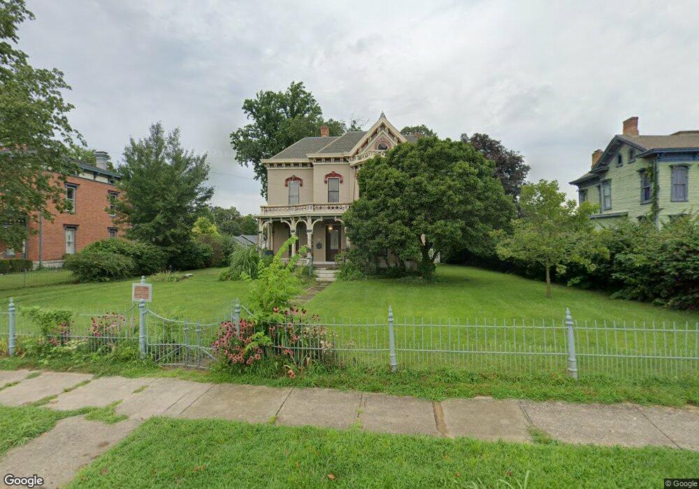
209 Oxford Rd Franklin, OH 45005
Estimated Value: $323,000 - $427,000
5
Beds
2
Baths
3,458
Sq Ft
$110/Sq Ft
Est. Value
About This Home
This home is located at 209 Oxford Rd, Franklin, OH 45005 and is currently estimated at $378,757, approximately $109 per square foot. 209 Oxford Rd is a home located in Warren County with nearby schools including Franklin High School.
Ownership History
Date
Name
Owned For
Owner Type
Purchase Details
Closed on
Sep 14, 2010
Sold by
Moses William D and Moses Paula J
Bought by
Wells Andrew T and Wiebusch Julie A
Current Estimated Value
Purchase Details
Closed on
May 14, 1996
Sold by
Salley David L
Bought by
Moses William D and Moses Paula J
Home Financials for this Owner
Home Financials are based on the most recent Mortgage that was taken out on this home.
Original Mortgage
$138,500
Outstanding Balance
$3,917
Interest Rate
7.78%
Mortgage Type
New Conventional
Estimated Equity
$374,840
Create a Home Valuation Report for This Property
The Home Valuation Report is an in-depth analysis detailing your home's value as well as a comparison with similar homes in the area
Home Values in the Area
Average Home Value in this Area
Purchase History
| Date | Buyer | Sale Price | Title Company |
|---|---|---|---|
| Wells Andrew T | $118,000 | Home Site Title Agency Inc | |
| Moses William D | $178,000 | -- |
Source: Public Records
Mortgage History
| Date | Status | Borrower | Loan Amount |
|---|---|---|---|
| Open | Moses William D | $138,500 |
Source: Public Records
Tax History
| Year | Tax Paid | Tax Assessment Tax Assessment Total Assessment is a certain percentage of the fair market value that is determined by local assessors to be the total taxable value of land and additions on the property. | Land | Improvement |
|---|---|---|---|---|
| 2025 | $5,312 | $112,890 | $22,500 | $90,390 |
| 2024 | $5,312 | $112,890 | $22,500 | $90,390 |
| 2023 | $4,626 | $88,196 | $14,892 | $73,304 |
| 2022 | $4,537 | $88,197 | $14,893 | $73,304 |
| 2021 | $4,371 | $88,197 | $14,893 | $73,304 |
| 2020 | $3,971 | $70,557 | $11,914 | $58,643 |
| 2019 | $3,618 | $70,557 | $11,914 | $58,643 |
| 2018 | $3,624 | $70,557 | $11,914 | $58,643 |
| 2017 | $3,868 | $68,975 | $11,820 | $57,155 |
| 2016 | $3,872 | $68,975 | $11,820 | $57,155 |
| 2015 | $3,872 | $68,975 | $11,820 | $57,155 |
| 2014 | $1,985 | $68,970 | $11,820 | $57,160 |
| 2013 | $3,367 | $77,240 | $13,240 | $64,000 |
Source: Public Records
Map
Nearby Homes
- 205 Oxford Rd
- 309 Oxford Rd
- 410 Park Ave
- 5 S River St
- 413 Spring Ave
- 0 E 4th St
- 509 Forest Ave
- 210 N Riley Blvd
- 511 Forest Ave
- 616 Lake Ave
- 605 Spring Ave
- 202 E 2nd St
- 627 S River St
- 228 Bridge St
- 712 Abney Ln
- 730 Park Ave
- 1200 Riley Blvd
- 0 Victoria Dr Unit 942075
- 0 Victoria Dr Unit 1852824
- 139 E 6th St
Your Personal Tour Guide
Ask me questions while you tour the home.