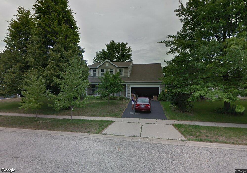
2090 Cumberland Pkwy Algonquin, IL 60102
Estimated Value: $378,790 - $416,000
4
Beds
3
Baths
2,036
Sq Ft
$196/Sq Ft
Est. Value
About This Home
This home is located at 2090 Cumberland Pkwy, Algonquin, IL 60102 and is currently estimated at $399,698, approximately $196 per square foot. 2090 Cumberland Pkwy is a home located in McHenry County with nearby schools including Algonquin Lakes Elementary School, Algonquin Middle School, and Dundee-Crown High School.
Ownership History
Date
Name
Owned For
Owner Type
Purchase Details
Closed on
Dec 2, 2015
Sold by
Nanni Dorothy M
Bought by
Nanni Michael J
Current Estimated Value
Create a Home Valuation Report for This Property
The Home Valuation Report is an in-depth analysis detailing your home's value as well as a comparison with similar homes in the area
Home Values in the Area
Average Home Value in this Area
Purchase History
| Date | Buyer | Sale Price | Title Company |
|---|---|---|---|
| Nanni Michael J | -- | Attorney |
Source: Public Records
Tax History Compared to Growth
Tax History
| Year | Tax Paid | Tax Assessment Tax Assessment Total Assessment is a certain percentage of the fair market value that is determined by local assessors to be the total taxable value of land and additions on the property. | Land | Improvement |
|---|---|---|---|---|
| 2024 | $9,010 | $123,176 | $18,813 | $104,363 |
| 2023 | $8,552 | $110,166 | $16,826 | $93,340 |
| 2022 | $7,367 | $91,898 | $18,689 | $73,209 |
| 2021 | $7,064 | $85,614 | $17,411 | $68,203 |
| 2020 | $6,877 | $82,584 | $16,795 | $65,789 |
| 2019 | $6,707 | $79,043 | $16,075 | $62,968 |
| 2018 | $6,962 | $79,040 | $17,764 | $61,276 |
| 2017 | $6,817 | $74,461 | $16,735 | $57,726 |
| 2016 | $6,713 | $69,838 | $15,696 | $54,142 |
| 2013 | -- | $71,755 | $14,642 | $57,113 |
Source: Public Records
Map
Nearby Homes
- 1943 Ozark Pkwy
- 2 Cumberland Pkwy
- 1782 Cumberland Pkwy
- 2150 E Algonquin Rd
- 1670 Yosemite Pkwy
- 1770 E Algonquin Rd
- Lot 4 b Ryan Pkwy
- 2003 Magenta Ln
- 1561 Cumberland Pkwy
- 460 Mahogany Dr
- 451 Mahogany Dr
- 1659 E Algonquin Rd
- 2008 Clematis Dr
- 2260 Indigo Dr
- 400 Diamond Back Way
- 9999 Sandbloom Rd
- 605 Claymont Ct
- 69 Alice St
- 920 Plymouth Ct
- 911 Old Oak Cir Unit 1
- 2100 Cumberland Pkwy
- 2080 Cumberland Pkwy
- 2070 Cumberland Pkwy
- 2002 Teton Pkwy
- 2060 Cumberland Pkwy
- 2004 Teton Pkwy
- 2120 Cumberland Pkwy
- 2001 Teton Pkwy
- 2101 Cumberland Pkwy
- 2006 Teton Pkwy
- 2003 Teton Pkwy
- 2050 Cumberland Pkwy
- 2111 Cumberland Pkwy
- 2005 Teton Pkwy
- 2130 Cumberland Pkwy
- 2007 Teton Pkwy
- 2008 Teton Pkwy
- 1961 Ozark Pkwy
- 2121 Cumberland Pkwy
- 2009 Teton Pkwy Unit 1