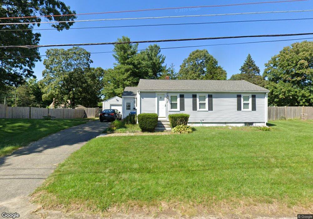
21 Dunn Ave Wrentham, MA 02093
Estimated Value: $496,964 - $600,000
2
Beds
3
Baths
1,034
Sq Ft
$523/Sq Ft
Est. Value
About This Home
This home is located at 21 Dunn Ave, Wrentham, MA 02093 and is currently estimated at $540,741, approximately $522 per square foot. 21 Dunn Ave is a home located in Norfolk County with nearby schools including Delaney Elementary School, Charles E Roderick, and Discovery Daycare Center.
Ownership History
Date
Name
Owned For
Owner Type
Purchase Details
Closed on
Jun 15, 2012
Sold by
Anacleto Susan A
Bought by
Anacleto Susan A and Anacleto Juan M
Current Estimated Value
Purchase Details
Closed on
Mar 30, 1995
Sold by
Hastings Timothy M and Hastings Lori J
Bought by
Polechronis Susan A
Home Financials for this Owner
Home Financials are based on the most recent Mortgage that was taken out on this home.
Original Mortgage
$92,300
Interest Rate
8.8%
Mortgage Type
Purchase Money Mortgage
Purchase Details
Closed on
Mar 25, 1987
Sold by
Miller Ronald P
Bought by
Hastings Timothy M
Create a Home Valuation Report for This Property
The Home Valuation Report is an in-depth analysis detailing your home's value as well as a comparison with similar homes in the area
Purchase History
| Date | Buyer | Sale Price | Title Company |
|---|---|---|---|
| Anacleto Susan A | -- | -- | |
| Polechronis Susan A | $131,900 | -- | |
| Hastings Timothy M | $129,000 | -- |
Source: Public Records
Mortgage History
| Date | Status | Borrower | Loan Amount |
|---|---|---|---|
| Previous Owner | Hastings Timothy M | $105,000 | |
| Previous Owner | Hastings Timothy M | $92,300 | |
| Previous Owner | Hastings Timothy M | $21,400 | |
| Previous Owner | Hastings Timothy M | $5,000 |
Source: Public Records
Tax History
| Year | Tax Paid | Tax Assessment Tax Assessment Total Assessment is a certain percentage of the fair market value that is determined by local assessors to be the total taxable value of land and additions on the property. | Land | Improvement |
|---|---|---|---|---|
| 2025 | $5,366 | $463,000 | $259,300 | $203,700 |
| 2024 | $4,967 | $413,900 | $259,300 | $154,600 |
| 2023 | $4,683 | $371,100 | $235,800 | $135,300 |
| 2022 | $4,708 | $344,400 | $220,000 | $124,400 |
| 2021 | $4,369 | $310,500 | $192,000 | $118,500 |
| 2020 | $4,094 | $287,300 | $170,800 | $116,500 |
| 2019 | $4,028 | $285,300 | $170,800 | $114,500 |
| 2018 | $4,147 | $291,200 | $170,800 | $120,400 |
| 2017 | $3,924 | $275,400 | $167,500 | $107,900 |
| 2016 | $3,853 | $269,800 | $162,600 | $107,200 |
| 2015 | $3,700 | $247,000 | $156,300 | $90,700 |
| 2014 | $3,641 | $237,800 | $150,400 | $87,400 |
Source: Public Records
Map
Nearby Homes
- 282 Thurston St
- 483 Thurston St
- 10 Nature View Dr
- 15 Nature View Dr
- 576 Dedham St
- 25 Foxboro Rd
- 131 Washington St Unit 50
- 8 Conway Ln
- 75 Foxboro Rd
- 12 Goodwin Dr
- 1 Weber Farm Rd Unit 1
- 3 Earle Stewart Ln
- 135 Creek St Unit 2
- 2 Earle Stewart Ln
- 10 Earle Stewart Ln Unit Lot 5
- 12 Earle Stewart Ln
- 11 Weber Farm Rd Unit 11
- 8 Weber Farm Rd Unit 8
- 30 Weber Farm Rd Unit 30
- 9 Sharon Ave
Your Personal Tour Guide
Ask me questions while you tour the home.