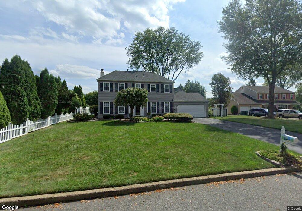
21 Markham Ct Langhorne, PA 19047
Estimated Value: $729,000 - $810,000
4
Beds
3
Baths
2,714
Sq Ft
$283/Sq Ft
Est. Value
About This Home
This home is located at 21 Markham Ct, Langhorne, PA 19047 and is currently estimated at $769,285, approximately $283 per square foot. 21 Markham Ct is a home located in Bucks County with nearby schools including Pearl S. Buck Elementary School, Maple Point Middle School, and Neshaminy High School.
Ownership History
Date
Name
Owned For
Owner Type
Purchase Details
Closed on
Dec 2, 2022
Sold by
Doorley Linda J
Bought by
Doorley Linda J
Current Estimated Value
Purchase Details
Closed on
Jun 18, 1991
Sold by
Greer
Bought by
Doorley Brian M and Doorley Linda J
Purchase Details
Closed on
Nov 18, 1985
Bought by
Greer
Create a Home Valuation Report for This Property
The Home Valuation Report is an in-depth analysis detailing your home's value as well as a comparison with similar homes in the area
Home Values in the Area
Average Home Value in this Area
Purchase History
| Date | Buyer | Sale Price | Title Company |
|---|---|---|---|
| Doorley Linda J | -- | None Listed On Document | |
| Doorley Brian M | $201,500 | -- | |
| Greer | -- | -- |
Source: Public Records
Tax History Compared to Growth
Tax History
| Year | Tax Paid | Tax Assessment Tax Assessment Total Assessment is a certain percentage of the fair market value that is determined by local assessors to be the total taxable value of land and additions on the property. | Land | Improvement |
|---|---|---|---|---|
| 2025 | $9,377 | $43,070 | $6,360 | $36,710 |
| 2024 | $9,377 | $43,070 | $6,360 | $36,710 |
| 2023 | $9,228 | $43,070 | $6,360 | $36,710 |
| 2022 | $8,985 | $43,070 | $6,360 | $36,710 |
| 2021 | $8,985 | $43,070 | $6,360 | $36,710 |
| 2020 | $8,878 | $43,070 | $6,360 | $36,710 |
| 2019 | $8,679 | $43,070 | $6,360 | $36,710 |
| 2018 | $8,520 | $43,070 | $6,360 | $36,710 |
| 2017 | $8,303 | $43,070 | $6,360 | $36,710 |
| 2016 | $8,303 | $43,070 | $6,360 | $36,710 |
| 2015 | $8,492 | $43,070 | $6,360 | $36,710 |
| 2014 | $8,492 | $43,070 | $6,360 | $36,710 |
Source: Public Records
Map
Nearby Homes
- 2602 Waterford Rd Unit 96
- 2703 Lynbrooke Dr Unit 81
- 2908 Brookhaven Dr
- 654A Woodford Ln
- 604 Wrensong Rd
- 1839 Windflower Ln
- 181 Fillmore Way
- 1651 Covington Rd Unit 26
- 1819 Windflower Ln
- 195 Roosevelt Dr
- 164 Tyler Way
- 28130 Hickory Ln
- 30139 Hickory Ln
- 1749 Locust Dr
- 81 Lavender Dr
- 24 Tupelo Ln
- 30 Tupelo Ln
- 0 Route 413 Bypass Unit PABU2010042
- 1536 Carlene Ct
- 705 Matthew Dr
- 128 Maple Point Dr
- 37 Markham Ct
- 22 Paxson Ln
- 160 Maple Point Dr
- 38 Paxson Ln
- 20 Markham Ct
- 96 Maple Point Dr
- 53 Markham Ct
- 36 Markham Ct
- 54 Paxson Ln
- 129 Maple Point Dr
- 52 Markham Ct
- 145 Maple Point Dr
- 113 Maple Point Dr
- 70 Paxson Ln
- 23 Paxson Ln
- 7 Paxson Ln
- 161 Maple Point Dr
- 19 Amity Ct
- 97 Maple Point Dr