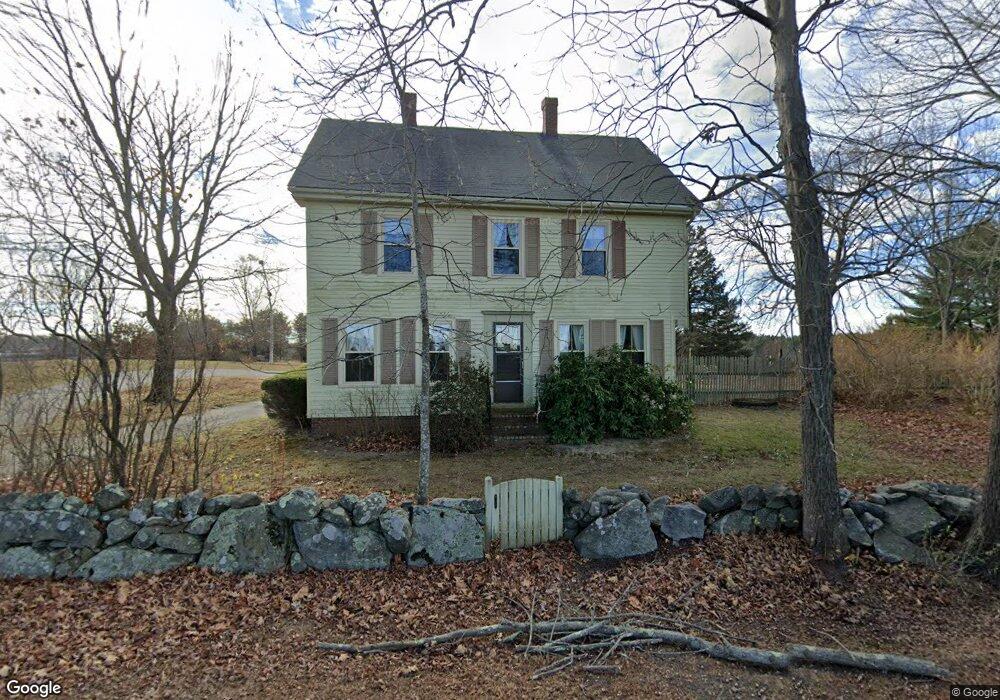
21 River Rd Stratham, NH 03885
Estimated Value: $591,000 - $701,000
3
Beds
2
Baths
1,784
Sq Ft
$361/Sq Ft
Est. Value
About This Home
This home is located at 21 River Rd, Stratham, NH 03885 and is currently estimated at $644,871, approximately $361 per square foot. 21 River Rd is a home located in Rockingham County with nearby schools including Stratham Memorial School, Cooperative Middle School, and Exeter High School.
Ownership History
Date
Name
Owned For
Owner Type
Purchase Details
Closed on
May 17, 2024
Sold by
Sherry Adrianne R
Bought by
Adrianne R Sherry Ret and Sherry
Current Estimated Value
Create a Home Valuation Report for This Property
The Home Valuation Report is an in-depth analysis detailing your home's value as well as a comparison with similar homes in the area
Home Values in the Area
Average Home Value in this Area
Purchase History
| Date | Buyer | Sale Price | Title Company |
|---|---|---|---|
| Adrianne R Sherry Ret | -- | None Available | |
| Adrianne R Sherry Ret | -- | None Available |
Source: Public Records
Tax History
| Year | Tax Paid | Tax Assessment Tax Assessment Total Assessment is a certain percentage of the fair market value that is determined by local assessors to be the total taxable value of land and additions on the property. | Land | Improvement |
|---|---|---|---|---|
| 2025 | $8,207 | $607,000 | $376,500 | $230,500 |
| 2024 | $7,964 | $607,000 | $376,500 | $230,500 |
| 2023 | $7,454 | $356,500 | $193,800 | $162,700 |
| 2022 | $6,670 | $356,500 | $193,800 | $162,700 |
| 2021 | $6,602 | $356,500 | $193,800 | $162,700 |
| 2020 | $6,756 | $356,500 | $193,800 | $162,700 |
| 2019 | $6,614 | $355,000 | $193,800 | $161,200 |
| 2018 | $8,496 | $287,900 | $144,300 | $143,600 |
| 2017 | $1,650 | $287,900 | $144,300 | $143,600 |
| 2016 | $6,522 | $287,900 | $144,300 | $143,600 |
| 2015 | $5,729 | $287,900 | $144,300 | $143,600 |
| 2014 | $5,778 | $290,200 | $144,300 | $145,900 |
| 2013 | $5,710 | $290,600 | $144,300 | $146,300 |
Source: Public Records
Map
Nearby Homes
- 31 Pinewood Dr
- 14 Doe Run Ln
- 105 Portsmouth Ave Unit 9
- 23 Winding Brook Dr
- 41 Hayes Mobile Home Park
- 51 Portsmouth Ave
- 21 Parkman Brook Ln
- 8 Cider Mill Ln
- 9 Captain's Way
- 3 Wheelwright Ave
- 34 Acadia Ln
- 0 High St Unit 2
- 10 Wingate Ct
- 10 String Bridge
- 15 High St Unit 2
- 163 Water St Unit B2
- 163 Water St Unit A1
- 196 Water St Unit 18
- 94 Wadleigh St Unit 32
- 24 Wadleigh St Unit 4
Your Personal Tour Guide
Ask me questions while you tour the home.