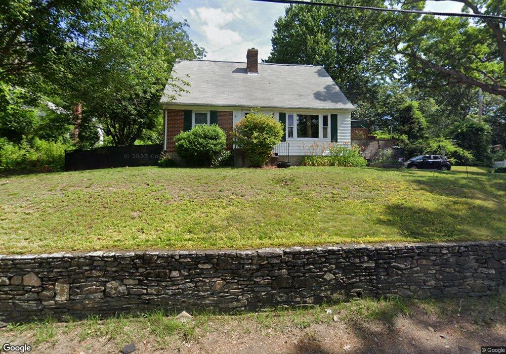
21 Rockaway Rd Auburn, MA 01501
Stoneville NeighborhoodEstimated Value: $327,000 - $479,000
4
Beds
2
Baths
1,733
Sq Ft
$244/Sq Ft
Est. Value
About This Home
This home is located at 21 Rockaway Rd, Auburn, MA 01501 and is currently estimated at $422,129, approximately $243 per square foot. 21 Rockaway Rd is a home located in Worcester County with nearby schools including Auburn Senior High School, Canterbury Street School, and Shrewsbury Montessori School - Auburn Campus.
Ownership History
Date
Name
Owned For
Owner Type
Purchase Details
Closed on
Aug 23, 2004
Sold by
Talbert Bret J and Talbert Melissa J
Bought by
Hanneman Rebecca A
Current Estimated Value
Home Financials for this Owner
Home Financials are based on the most recent Mortgage that was taken out on this home.
Original Mortgage
$145,000
Interest Rate
6.03%
Mortgage Type
Purchase Money Mortgage
Purchase Details
Closed on
Dec 19, 1997
Sold by
Est Nelson Carl F and Nelson Ralph W
Bought by
Talbert Bret J and Talbert Melissa J
Home Financials for this Owner
Home Financials are based on the most recent Mortgage that was taken out on this home.
Original Mortgage
$97,500
Interest Rate
7.14%
Mortgage Type
Purchase Money Mortgage
Create a Home Valuation Report for This Property
The Home Valuation Report is an in-depth analysis detailing your home's value as well as a comparison with similar homes in the area
Home Values in the Area
Average Home Value in this Area
Purchase History
| Date | Buyer | Sale Price | Title Company |
|---|---|---|---|
| Hanneman Rebecca A | $264,900 | -- | |
| Talbert Bret J | -- | -- | |
| Talbert Bret J | $105,000 | -- |
Source: Public Records
Mortgage History
| Date | Status | Borrower | Loan Amount |
|---|---|---|---|
| Open | Talbert Bret J | $138,500 | |
| Closed | Hanneman Rebecca A | $145,000 | |
| Previous Owner | Talbert Bret J | $114,500 | |
| Previous Owner | Talbert Bret J | $20,000 | |
| Previous Owner | Talbert Bret J | $97,500 |
Source: Public Records
Tax History Compared to Growth
Tax History
| Year | Tax Paid | Tax Assessment Tax Assessment Total Assessment is a certain percentage of the fair market value that is determined by local assessors to be the total taxable value of land and additions on the property. | Land | Improvement |
|---|---|---|---|---|
| 2025 | $48 | $332,600 | $109,100 | $223,500 |
| 2024 | $4,721 | $316,200 | $104,000 | $212,200 |
| 2023 | $4,645 | $292,500 | $94,500 | $198,000 |
| 2022 | $4,343 | $258,200 | $94,500 | $163,700 |
| 2021 | $4,029 | $222,100 | $83,400 | $138,700 |
| 2020 | $3,896 | $216,700 | $83,400 | $133,300 |
| 2019 | $3,748 | $203,500 | $78,300 | $125,200 |
| 2018 | $3,542 | $192,100 | $73,200 | $118,900 |
| 2017 | $3,316 | $180,800 | $66,400 | $114,400 |
| 2016 | $3,200 | $176,900 | $69,500 | $107,400 |
| 2015 | $3,026 | $175,300 | $69,500 | $105,800 |
| 2014 | $2,960 | $171,200 | $66,100 | $105,100 |
Source: Public Records
Map
Nearby Homes
- 19 Forest Dr
- 8 Shirley St
- 15 Adella St
- 61 Elmwood St
- 32 Field St
- 148 Hampton St
- 24 Meena Dr
- 216-220 Hampton St
- 204-212 Hampton St
- 5 Commonwealth Ave
- 104 Elmwood St
- 1 Amesbury St
- 45 Jerome Ave
- 177 Boyce St
- 25 Vinal St Unit 30
- 16 Dixon Ave
- 7 Carroll St
- 36 Laurier St
- 801 Forest Park Dr Unit 801
- 35 Pinehurst Ave