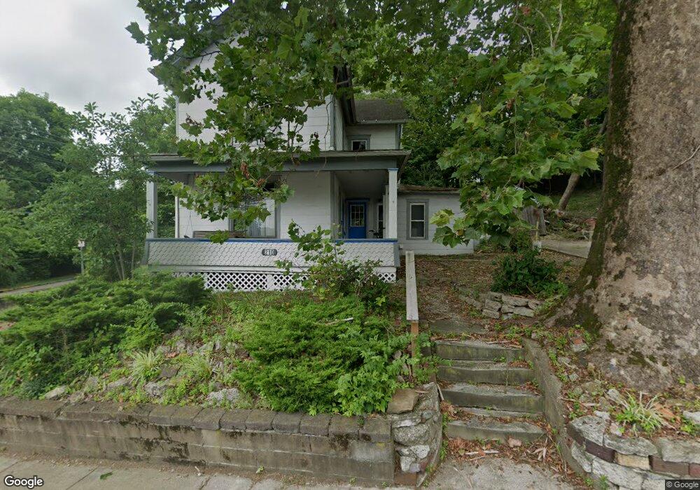
210 W State St Athens, OH 45701
Estimated Value: $197,000 - $253,000
5
Beds
2
Baths
1,840
Sq Ft
$119/Sq Ft
Est. Value
About This Home
This home is located at 210 W State St, Athens, OH 45701 and is currently estimated at $218,573, approximately $118 per square foot. 210 W State St is a home located in Athens County with nearby schools including West Elementary School, Athens Middle School, and Athens High School.
Ownership History
Date
Name
Owned For
Owner Type
Purchase Details
Closed on
Oct 12, 2021
Sold by
200 And 210 West State Llc
Bought by
Pinehill Road Llc
Current Estimated Value
Home Financials for this Owner
Home Financials are based on the most recent Mortgage that was taken out on this home.
Original Mortgage
$124,875
Outstanding Balance
$113,874
Interest Rate
2.8%
Mortgage Type
New Conventional
Estimated Equity
$104,699
Purchase Details
Closed on
Jul 16, 2021
Sold by
Hoshower Leon B and Hoshower Linda J
Bought by
200 And 210 West State Llc
Purchase Details
Closed on
May 20, 2016
Sold by
Hoshower Leon B
Bought by
200 & 210 West State Llc
Purchase Details
Closed on
Jan 11, 2013
Sold by
Equity Holdings Ltd
Bought by
Hoshower Leon and Hoshower Linda
Purchase Details
Closed on
Jan 17, 1997
Bought by
Hoshower Leon B
Purchase Details
Closed on
May 1, 1988
Create a Home Valuation Report for This Property
The Home Valuation Report is an in-depth analysis detailing your home's value as well as a comparison with similar homes in the area
Home Values in the Area
Average Home Value in this Area
Purchase History
| Date | Buyer | Sale Price | Title Company |
|---|---|---|---|
| Pinehill Road Llc | -- | None Listed On Document | |
| 200 And 210 West State Llc | -- | Secured Title | |
| 200 & 210 West State Llc | -- | Attorney | |
| Hoshower Leon | -- | Attorney | |
| Hoshower Leon B | -- | -- | |
| -- | $44,000 | -- |
Source: Public Records
Mortgage History
| Date | Status | Borrower | Loan Amount |
|---|---|---|---|
| Open | Pinehill Road Llc | $124,875 |
Source: Public Records
Tax History Compared to Growth
Tax History
| Year | Tax Paid | Tax Assessment Tax Assessment Total Assessment is a certain percentage of the fair market value that is determined by local assessors to be the total taxable value of land and additions on the property. | Land | Improvement |
|---|---|---|---|---|
| 2024 | $3,240 | $58,380 | $5,620 | $52,760 |
| 2023 | $2,889 | $58,380 | $5,620 | $52,760 |
| 2022 | $2,425 | $46,850 | $5,620 | $41,230 |
| 2021 | $2,490 | $46,850 | $5,620 | $41,230 |
| 2020 | $2,415 | $46,850 | $5,620 | $41,230 |
| 2019 | $2,343 | $44,830 | $4,840 | $39,990 |
| 2018 | $2,313 | $44,830 | $4,840 | $39,990 |
| 2017 | $3,993 | $44,830 | $4,840 | $39,990 |
| 2016 | $1,993 | $39,920 | $4,610 | $35,310 |
| 2015 | $3,646 | $39,920 | $4,610 | $35,310 |
| 2014 | $3,646 | $39,920 | $4,610 | $35,310 |
| 2013 | $3,476 | $39,110 | $4,610 | $34,500 |
Source: Public Records
Map
Nearby Homes
- 214 W State St
- 10 1st St
- 11 Walker St
- 31 1st St
- 56.15/15.5 Central & Clark
- 12 Walker St
- 18 Clarke St
- 15 S Shafer St Unit 1509
- 7 Elizabeth Dr
- 98 Central Ave
- 0 Roberts St
- 71 W Washington St
- 193 N Lancaster St
- 17 Ring St
- 80 Court
- 64 Franklin Ave
- 131 Grosvenor St
- 550 W Union St
- 115 University Estates Blvd
- 273 E State St