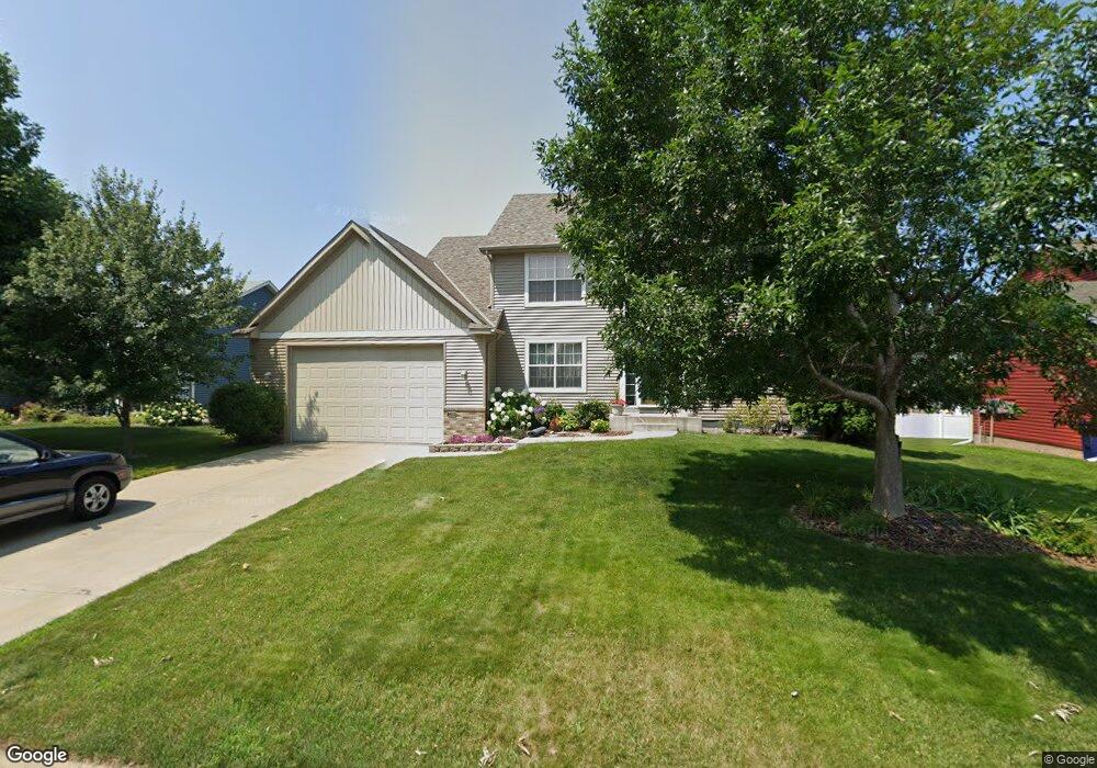
2106 Ormond Dr Shakopee, MN 55379
Estimated Value: $474,158 - $531,000
3
Beds
3
Baths
2,230
Sq Ft
$226/Sq Ft
Est. Value
About This Home
This home is located at 2106 Ormond Dr, Shakopee, MN 55379 and is currently estimated at $504,540, approximately $226 per square foot. 2106 Ormond Dr is a home located in Scott County with nearby schools including Sun Path Elementary School, Shakopee West Middle School, and Shakopee Senior High School.
Ownership History
Date
Name
Owned For
Owner Type
Purchase Details
Closed on
Nov 8, 2007
Sold by
Chadha Vikrant and Chadha Preeti
Bought by
Skarie Daniel S and Skarie Jennifer M
Current Estimated Value
Purchase Details
Closed on
Feb 1, 2006
Sold by
Skarie Daniel and Skarie Jennifer
Bought by
Chadha Vikrant
Purchase Details
Closed on
Jan 28, 2003
Sold by
Key-Land Homes
Bought by
Skarie Daniel S and Skarie Jennifer M
Create a Home Valuation Report for This Property
The Home Valuation Report is an in-depth analysis detailing your home's value as well as a comparison with similar homes in the area
Home Values in the Area
Average Home Value in this Area
Purchase History
| Date | Buyer | Sale Price | Title Company |
|---|---|---|---|
| Skarie Daniel S | $410,000 | -- | |
| Chadha Vikrant | $410,000 | -- | |
| Skarie Daniel S | $327,796 | -- | |
| Key-Land Homes | $82,555 | -- |
Source: Public Records
Tax History
| Year | Tax Paid | Tax Assessment Tax Assessment Total Assessment is a certain percentage of the fair market value that is determined by local assessors to be the total taxable value of land and additions on the property. | Land | Improvement |
|---|---|---|---|---|
| 2025 | $4,624 | $439,500 | $140,700 | $298,800 |
| 2024 | $4,822 | $443,700 | $140,700 | $303,000 |
| 2023 | $5,052 | $450,100 | $135,300 | $314,800 |
| 2022 | $4,614 | $463,100 | $153,700 | $309,400 |
| 2021 | $3,962 | $365,400 | $122,000 | $243,400 |
| 2020 | $4,320 | $344,300 | $117,000 | $227,300 |
| 2019 | $4,420 | $330,300 | $104,000 | $226,300 |
| 2018 | $4,244 | $0 | $0 | $0 |
| 2016 | $4,166 | $0 | $0 | $0 |
| 2014 | -- | $0 | $0 | $0 |
Source: Public Records
Map
Nearby Homes
- 2577 Green Ash Ave
- 2554 Green Ash Ave
- 2578 Green Ash Ave
- 2566 Green Ash Ave
- 2542 Green Ash Ave
- 2530 Green Ash Ave
- 2354 Ponds Way
- 2468 Valley View Rd
- 2697 Aspen Dr
- 2584 Aspen Ct
- 2624 Aspen Dr
- 2642 Aspen Dr
- 2660 Aspen Dr
- 2694 Aspen Dr
- 2397 Rock Elm Rd
- 2542 Mathias Rd
- 3432 Baneberry Cir
- 2113 Sandhill Dr
- 1976 Alden Ave
- 3300 Valley View Rd
- 2098 Ormond Dr
- 2114 Ormond Dr
- 2105 Williams St
- 2113 Williams St
- 2097 Williams St
- 2090 Ormond Dr
- 2122 Ormond Dr
- 2111 Ormond Dr
- 2121 Williams St
- 2119 Ormond Dr
- 2103 Ormond Dr
- 2089 Williams St
- 2130 Ormond Dr
- 2095 Ormond Dr
- 2082 Ormond Dr
- 2129 Williams St
- 2081 Williams St
- 2135 Ormond Dr
- 2087 Ormond Dr
- 2108 Elsberry Curve
Your Personal Tour Guide
Ask me questions while you tour the home.