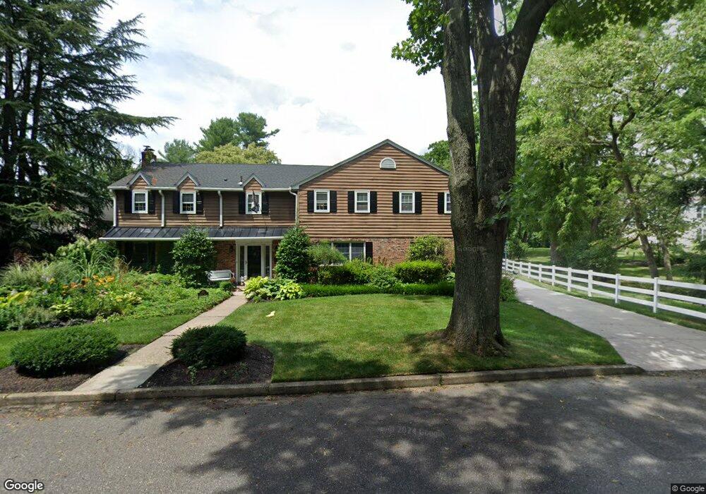
211 Moore Ln Haddonfield, NJ 08033
Estimated Value: $1,740,686 - $1,973,000
6
Beds
5
Baths
4,476
Sq Ft
$418/Sq Ft
Est. Value
About This Home
This home is located at 211 Moore Ln, Haddonfield, NJ 08033 and is currently estimated at $1,871,229, approximately $418 per square foot. 211 Moore Ln is a home located in Camden County with nearby schools including Haddonfield Memorial High School, Haddonfield Friends School, and Christ the King Regional School.
Ownership History
Date
Name
Owned For
Owner Type
Purchase Details
Closed on
Jul 20, 2020
Sold by
Mclister Charles and Uffner Elizabeth
Bought by
Mclister Charles Stewart and Mclister Elizabeth Wolf
Current Estimated Value
Home Financials for this Owner
Home Financials are based on the most recent Mortgage that was taken out on this home.
Original Mortgage
$771,000
Interest Rate
2.8%
Mortgage Type
New Conventional
Purchase Details
Closed on
Dec 28, 2017
Sold by
Vandervort Anthony E and Van Dervort Tara
Bought by
Mclister Charles and Mclister Elizabeth
Home Financials for this Owner
Home Financials are based on the most recent Mortgage that was taken out on this home.
Original Mortgage
$779,000
Interest Rate
3.92%
Mortgage Type
Commercial
Purchase Details
Closed on
Dec 2, 2002
Sold by
Lindenberg Albert E
Bought by
Dervort Anthony E Van and Dervort Tata K
Home Financials for this Owner
Home Financials are based on the most recent Mortgage that was taken out on this home.
Original Mortgage
$475,000
Interest Rate
6.18%
Mortgage Type
Purchase Money Mortgage
Purchase Details
Closed on
Apr 30, 1998
Sold by
Estate Of Madeline M Deal
Bought by
Lindenberg Albert E and Lindenberg Lisa
Home Financials for this Owner
Home Financials are based on the most recent Mortgage that was taken out on this home.
Original Mortgage
$227,000
Interest Rate
7.03%
Mortgage Type
Purchase Money Mortgage
Create a Home Valuation Report for This Property
The Home Valuation Report is an in-depth analysis detailing your home's value as well as a comparison with similar homes in the area
Home Values in the Area
Average Home Value in this Area
Purchase History
| Date | Buyer | Sale Price | Title Company |
|---|---|---|---|
| Mclister Charles Stewart | -- | None Listed On Document | |
| Mclister Charles | $879,000 | Surety Title Co | |
| Dervort Anthony E Van | $700,000 | -- | |
| Lindenberg Albert E | -- | -- | |
| Lindenberg Albert E | $345,000 | -- |
Source: Public Records
Mortgage History
| Date | Status | Borrower | Loan Amount |
|---|---|---|---|
| Previous Owner | Mclister Charles Stewart | $771,000 | |
| Previous Owner | Mclister Charles | $779,000 | |
| Previous Owner | Lindenberg Albert E | $475,000 | |
| Previous Owner | Lindenberg Albert E | $227,000 |
Source: Public Records
Tax History
| Year | Tax Paid | Tax Assessment Tax Assessment Total Assessment is a certain percentage of the fair market value that is determined by local assessors to be the total taxable value of land and additions on the property. | Land | Improvement |
|---|---|---|---|---|
| 2025 | $29,079 | $900,000 | $378,300 | $521,700 |
| 2024 | $29,079 | $900,000 | $378,300 | $521,700 |
| 2023 | $28,692 | $900,000 | $378,300 | $521,700 |
| 2022 | $28,467 | $900,000 | $378,300 | $521,700 |
| 2021 | $28,323 | $900,000 | $378,300 | $521,700 |
| 2020 | $28,125 | $900,000 | $378,300 | $521,700 |
| 2019 | $279 | $900,000 | $378,300 | $521,700 |
| 2018 | $29,099 | $950,000 | $378,300 | $571,700 |
| 2017 | $28,405 | $950,000 | $378,300 | $571,700 |
| 2016 | $27,769 | $950,000 | $378,300 | $571,700 |
| 2015 | $26,999 | $950,000 | $378,300 | $571,700 |
| 2014 | $26,401 | $950,000 | $378,300 | $571,700 |
Source: Public Records
Map
Nearby Homes
- 125 W Cottage Ave
- 33 Estaugh Ave
- 35 Estaugh Ave
- 109 S Atlantic Ave
- 344 Knolltop Ln
- 370 Station Ave
- 109 W Euclid Ave
- 25 W Euclid Ave
- 121 Reillywood Ave
- 107 Centre St
- 13 Wilkins Ave
- 75 Birchall Dr
- 313 Woodland Ave
- 38 Birchall Dr
- 166 Ellis St
- 32 Potter St
- 60 Potter St
- 30 Potter St
- 414 Tavistock
- 286-288 Lake St
Your Personal Tour Guide
Ask me questions while you tour the home.