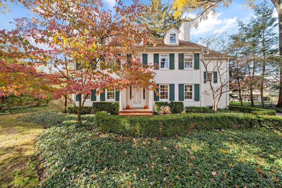
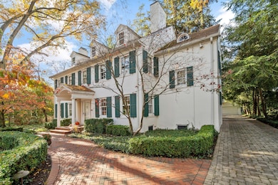
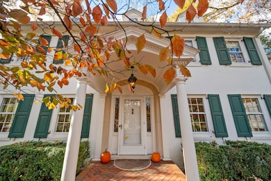
211 Preston Rd Columbus, OH 43209
Estimated payment $9,048/month
Highlights
- 0.46 Acre Lot
- Traditional Architecture
- No HOA
- Multiple Fireplaces
- Wood Flooring
- 2 Car Detached Garage
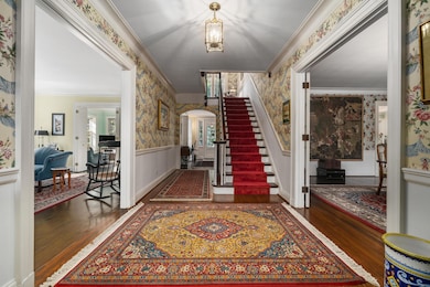
About This Home
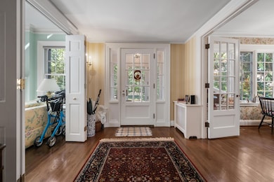
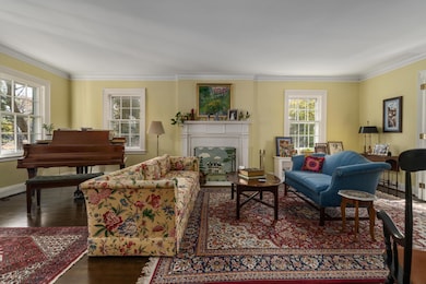
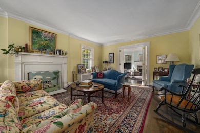
Handsome Center Hall Colonial with architectural craftmanship in detail of the crown moldings, archways, built-ins, fireplaces, base moldings, large sun lighted rooms with lots of windows and refinished hardwood oak flooring. Preston Road is a beautiful tree lined street and a highlight on the East side of Columbus. This home has a Holiday sized dining room and a Holiday sized living room! Large gourmet kitchen with custom white cabinetry and designer tile and back splash. The perfect flow for entertaining of every season with Family and Friends! Back yard is a sanctuary of repose and quiet reading spaces enhanced by an arbor of trees and patio ! Easy access to downtown, airport, shopping, Bexley's Main Street restaurants, shops and boutiques! Professional photos are being done on 11/12/2025 and will be posted on 11/13/2025 when showings begin.
Home Details
Home Type
- Single Family
Est. Annual Taxes
- $18,540
Year Built
- Built in 1920
Parking
- 2 Car Detached Garage
- Garage Door Opener
Home Design
- Traditional Architecture
- Brick Exterior Construction
- Stone Foundation
- Stucco Exterior
Interior Spaces
- 4,908 Sq Ft Home
- 2.5-Story Property
- Crown Molding
- Multiple Fireplaces
- Family Room
- Basement Fills Entire Space Under The House
- Laundry on lower level
Kitchen
- Gas Range
- Dishwasher
Flooring
- Wood
- Ceramic Tile
Bedrooms and Bathrooms
- 5 Bedrooms
Home Security
- Home Security System
- Storm Windows
Utilities
- Boiler Heating System
- Heating System Uses Gas
- Hot Water Heating System
- Gas Water Heater
Additional Features
- Patio
- 0.46 Acre Lot
Community Details
- No Home Owners Association
Listing and Financial Details
- Assessor Parcel Number 010-038305
Map
Home Values in the Area
Average Home Value in this Area
Tax History
| Year | Tax Paid | Tax Assessment Tax Assessment Total Assessment is a certain percentage of the fair market value that is determined by local assessors to be the total taxable value of land and additions on the property. | Land | Improvement |
|---|---|---|---|---|
| 2024 | $18,540 | $413,110 | $127,750 | $285,360 |
| 2023 | $18,303 | $413,110 | $127,750 | $285,360 |
| 2022 | $14,430 | $278,220 | $70,460 | $207,760 |
| 2021 | $14,455 | $278,220 | $70,460 | $207,760 |
| 2020 | $14,474 | $278,220 | $70,460 | $207,760 |
| 2019 | $15,368 | $253,330 | $64,050 | $189,280 |
| 2018 | $16,400 | $253,330 | $64,050 | $189,280 |
| 2017 | $15,358 | $253,330 | $64,050 | $189,280 |
| 2016 | $19,239 | $290,430 | $70,000 | $220,430 |
| 2015 | $17,465 | $290,430 | $70,000 | $220,430 |
| 2014 | $17,507 | $290,430 | $70,000 | $220,430 |
| 2013 | $7,849 | $264,005 | $63,630 | $200,375 |
Property History
| Date | Event | Price | List to Sale | Price per Sq Ft |
|---|---|---|---|---|
| 11/13/2025 11/13/25 | For Sale | $1,425,000 | -- | $290 / Sq Ft |
Purchase History
| Date | Type | Sale Price | Title Company |
|---|---|---|---|
| Deed | $420,000 | -- |
Source: Columbus and Central Ohio Regional MLS
MLS Number: 225042726
APN: 010-038305
Disclaimer: Certain information contained herein is derived from information provided by parties other than Homes.com. All information provided is deemed reliable, but is not guaranteed to be accurate and should be independently verified.
![]() IDX information is provided exclusively for personal, non-commercial use, and may not be used for any purpose other than to identify prospective properties consumers may be interested in purchasing.
IDX information is provided exclusively for personal, non-commercial use, and may not be used for any purpose other than to identify prospective properties consumers may be interested in purchasing.
Information is deemed reliable but not guaranteed.
- 57 Preston Rd
- 419 Westland Ave
- 1833 Franklin Ave
- 1825-1827 Bryden Rd
- 2430 Plymouth Ave
- 1786 E Rich St Unit 788
- 2455 Dale Ave
- 1714 Oak St
- 268 S Cassady Ave
- 1669-1671 Oak St
- 1692 Bryden Rd
- 1779 E Main St
- 2425 Bryden Rd
- 395-397 Stoddart Ave
- 592 Rhoads Ave Unit 594
- 1000 S Dawson Ave Unit 302
- 572 Bulen Ave
- 1596 Franklin Ave Unit 598
- 1747 E Mound St
- 1880 Greenway Ave S
- 485 S Parkview Ave
- 1756 Oak St Unit 758
- 2352-2358 E Main St
- 1728 E Long St
- 423 Stoddart Ave
- 1599 Oak St
- 1687 E Mound St
- 738 Sheridan Ave
- 736 Sheridan Ave
- 1551 Bryden Rd
- 1750 Clifton Ave
- 2629 E Broad St
- 1513 Oak St
- 597 Seymour Ave
- 264 Miller Ave
- 245 Miller Ave
- 839 Sheridan Ave
- 1455 Franklin Ave
- 719 Fairwood Ave
- 222 Parkwood Ave
