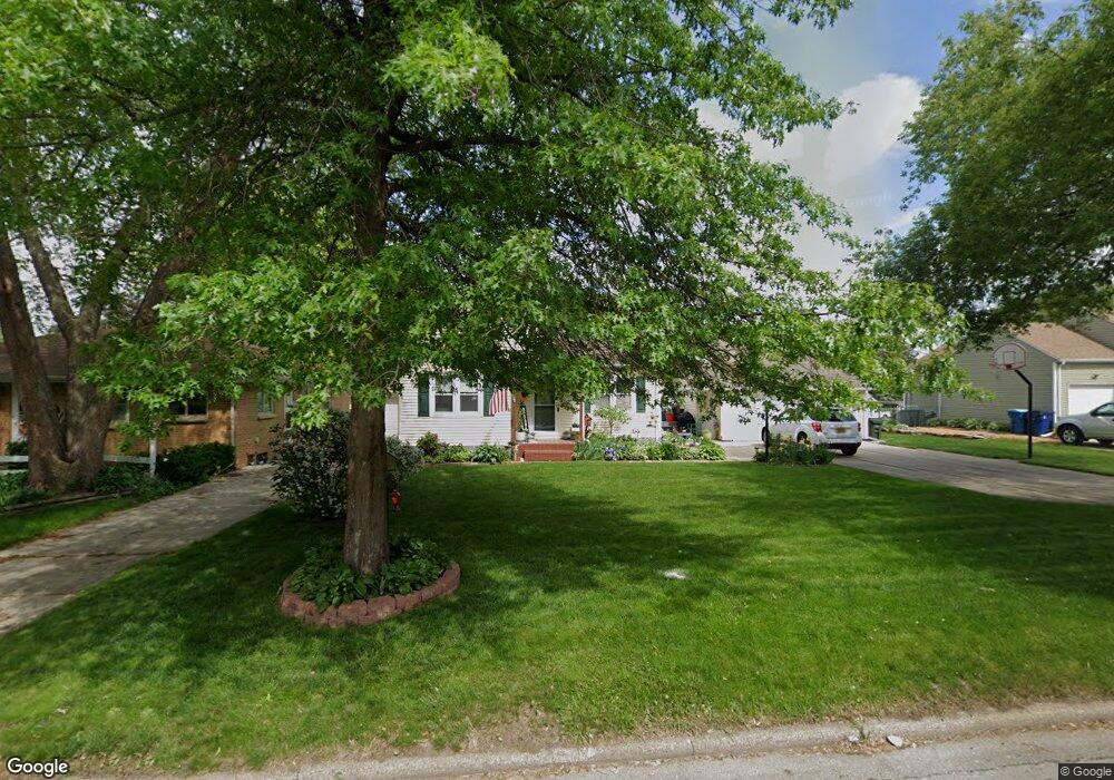
2111 W 7th St Waterloo, IA 50702
Liberty Park NeighborhoodEstimated Value: $162,000 - $193,000
3
Beds
2
Baths
1,417
Sq Ft
$128/Sq Ft
Est. Value
About This Home
This home is located at 2111 W 7th St, Waterloo, IA 50702 and is currently estimated at $181,996, approximately $128 per square foot. 2111 W 7th St is a home located in Black Hawk County with nearby schools including Kittrell Elementary School, Hoover Middle School, and West High School.
Ownership History
Date
Name
Owned For
Owner Type
Purchase Details
Closed on
Apr 30, 2007
Sold by
Smith David D and Smith Jill L E
Bought by
Pruis Joellen Anne and Pruis Tony Dale
Current Estimated Value
Home Financials for this Owner
Home Financials are based on the most recent Mortgage that was taken out on this home.
Original Mortgage
$136,550
Outstanding Balance
$81,878
Interest Rate
6.18%
Mortgage Type
New Conventional
Estimated Equity
$100,118
Create a Home Valuation Report for This Property
The Home Valuation Report is an in-depth analysis detailing your home's value as well as a comparison with similar homes in the area
Home Values in the Area
Average Home Value in this Area
Purchase History
| Date | Buyer | Sale Price | Title Company |
|---|---|---|---|
| Pruis Joellen Anne | $138,000 | None Available |
Source: Public Records
Mortgage History
| Date | Status | Borrower | Loan Amount |
|---|---|---|---|
| Open | Pruis Joellen Anne | $136,550 |
Source: Public Records
Tax History
| Year | Tax Paid | Tax Assessment Tax Assessment Total Assessment is a certain percentage of the fair market value that is determined by local assessors to be the total taxable value of land and additions on the property. | Land | Improvement |
|---|---|---|---|---|
| 2025 | $3,622 | $197,170 | $26,600 | $170,570 |
| 2024 | $3,622 | $177,230 | $26,600 | $150,630 |
| 2023 | $2,958 | $177,230 | $26,600 | $150,630 |
| 2022 | $2,878 | $143,600 | $26,600 | $117,000 |
| 2021 | $2,762 | $143,600 | $26,600 | $117,000 |
| 2020 | $2,712 | $130,510 | $20,900 | $109,610 |
| 2019 | $2,712 | $130,510 | $20,900 | $109,610 |
| 2018 | $2,716 | $130,510 | $20,900 | $109,610 |
| 2017 | $2,802 | $130,510 | $20,900 | $109,610 |
| 2016 | $2,764 | $130,510 | $20,900 | $109,610 |
| 2015 | $2,764 | $130,510 | $20,900 | $109,610 |
| 2014 | $2,682 | $124,740 | $20,900 | $103,840 |
Source: Public Records
Map
Nearby Homes
- 819 Easton Ave
- 922 E Mitchell Ave
- 814 E Mitchell Ave
- 1103 Easton Ave
- 1809 Baltimore St
- 1107 E Mitchell Ave
- 1141 E Mitchell Ave
- 1150 Easton Ave
- 2547 W 9th St
- 2425 Randolph St
- 2527 Randolph St
- 1171 Liberty Ave
- 1002 E Ridgeway Ave
- 1219 Hammond Ave
- 812 Hawthorne Ave
- 2506 Laurel St
- 216 Bourland Ave
- 610 Burbank Ave
- 1115 Hawthorne Ave
- 1017 Forest Ave
- 2109 W 7th St
- 2121 W 7th St
- 917 Cornwall Ave
- 2101 W 7th St
- 916 Bourland Ave
- 919 Cornwall Ave
- 2112 W 7th St
- 2118 W 7th St
- 2100 W 7th St
- 920 Bourland Ave
- 2106 W 7th St
- 2122 W 7th St
- 2203 W 7th St
- 925 Cornwall Ave
- 2025 W 7th St
- 928 Bourland Ave
- 2200 W 7th St
- 933 Cornwall Ave
- 2207 W 7th St
- 916 Cornwall Ave
Your Personal Tour Guide
Ask me questions while you tour the home.