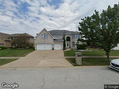
21121 Alessandra Dr Matteson, IL 60443
West Matteson NeighborhoodEstimated Value: $407,425 - $511,000
4
Beds
3
Baths
3,889
Sq Ft
$115/Sq Ft
Est. Value
About This Home
This home is located at 21121 Alessandra Dr, Matteson, IL 60443 and is currently estimated at $447,856, approximately $115 per square foot. 21121 Alessandra Dr is a home located in Cook County with nearby schools including Colin Powell Middle School and Southland College Prep.
Ownership History
Date
Name
Owned For
Owner Type
Purchase Details
Closed on
Nov 17, 2008
Sold by
Federal Home Loan Mortgage Corporation
Bought by
Bullock Richard and Wilkerson Money
Current Estimated Value
Home Financials for this Owner
Home Financials are based on the most recent Mortgage that was taken out on this home.
Original Mortgage
$348,907
Outstanding Balance
$234,181
Interest Rate
6.04%
Mortgage Type
FHA
Estimated Equity
$205,350
Purchase Details
Closed on
Sep 17, 2007
Sold by
Gee Dwayne
Bought by
Federal Home Loan Mortgage Corporation
Purchase Details
Closed on
Jan 17, 2006
Sold by
State Bank Of Countryside
Bought by
Gee Dwayne and Gee Jewell R
Home Financials for this Owner
Home Financials are based on the most recent Mortgage that was taken out on this home.
Original Mortgage
$364,592
Interest Rate
6.2%
Mortgage Type
Fannie Mae Freddie Mac
Create a Home Valuation Report for This Property
The Home Valuation Report is an in-depth analysis detailing your home's value as well as a comparison with similar homes in the area
Home Values in the Area
Average Home Value in this Area
Purchase History
| Date | Buyer | Sale Price | Title Company |
|---|---|---|---|
| Bullock Richard | $308,000 | Attorneys Title Guaranty Fun | |
| Federal Home Loan Mortgage Corporation | -- | None Available | |
| Gee Dwayne | $365,000 | Cti |
Source: Public Records
Mortgage History
| Date | Status | Borrower | Loan Amount |
|---|---|---|---|
| Open | Wilkerson Money | $88,919 | |
| Closed | Wilkerson Money | $12,167 | |
| Open | Bullock Richard | $348,907 | |
| Previous Owner | Gee Dwayne | $364,592 |
Source: Public Records
Tax History Compared to Growth
Tax History
| Year | Tax Paid | Tax Assessment Tax Assessment Total Assessment is a certain percentage of the fair market value that is determined by local assessors to be the total taxable value of land and additions on the property. | Land | Improvement |
|---|---|---|---|---|
| 2024 | $10,253 | $38,000 | $5,584 | $32,416 |
| 2023 | $10,253 | $38,000 | $5,584 | $32,416 |
| 2022 | $10,253 | $22,571 | $4,823 | $17,748 |
| 2021 | $11,345 | $24,322 | $4,822 | $19,500 |
| 2020 | $11,081 | $24,322 | $4,822 | $19,500 |
| 2019 | $14,192 | $29,405 | $4,315 | $25,090 |
| 2018 | $15,191 | $31,649 | $4,315 | $27,334 |
| 2017 | $14,802 | $31,649 | $4,315 | $27,334 |
| 2016 | $13,558 | $28,697 | $3,807 | $24,890 |
| 2015 | $14,127 | $30,425 | $3,807 | $26,618 |
| 2014 | $13,771 | $30,425 | $3,807 | $26,618 |
| 2013 | $11,037 | $26,620 | $3,807 | $22,813 |
Source: Public Records
Map
Nearby Homes
- 1005 Regent Dr
- 977 Regent Dr
- 997 Regent Dr
- 985 Regent Dr
- 6361 Patricia Dr
- 6201 Pond View Dr
- 919 Dartmouth Ave
- 6417 Blue Sky Ln Unit 2525
- 6409 Old Plank Blvd
- 70 Begonia Dr
- 6500 Pasture Side Trail
- 824 Dartmouth Ave
- 957 Harvard Ln
- 5657 Colgate Ln
- 749 Old Meadow Rd
- 51 Brushwood Dr
- 5631 Colgate Ln
- 235 Poppy Ln
- 91 Candlegate Cir
- 6520 Bridle Path Dr
- 21121 Alessandra Dr
- 21127 Alessandra Dr
- 21117 Alessandra Dr
- 21133 Alessandra Dr
- 21113 Alessandra Dr
- 6101 Alessandra Dr
- 21126 Alessandra Dr
- 21139 Alessandra Dr
- 6060 Alessandra Dr
- 21132 Alessandra Dr
- 6105 Alessandra Dr
- 21138 Alessandra Dr
- 21145 Alessandra Dr
- 6106 Alessandra Dr
- 21129 Sophia Dr
- 21144 Alessandra Dr
- 21135 Sophia Dr
- 21151 Alessandra Dr
- 21141 Sophia Dr
- 21150 Alessandra Dr