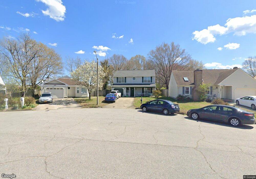
2113 Little Rock Ct Virginia Beach, VA 23456
Landstown NeighborhoodEstimated Value: $415,000 - $441,000
4
Beds
3
Baths
1,904
Sq Ft
$223/Sq Ft
Est. Value
About This Home
This home is located at 2113 Little Rock Ct, Virginia Beach, VA 23456 and is currently estimated at $425,228, approximately $223 per square foot. 2113 Little Rock Ct is a home located in Virginia Beach City with nearby schools including Landstown Elementary School, Landstown Middle School, and Landstown High School.
Ownership History
Date
Name
Owned For
Owner Type
Purchase Details
Closed on
Feb 21, 2002
Sold by
Mckee Douglas
Bought by
Pearson Louis
Current Estimated Value
Home Financials for this Owner
Home Financials are based on the most recent Mortgage that was taken out on this home.
Original Mortgage
$134,500
Outstanding Balance
$54,788
Interest Rate
6.85%
Mortgage Type
VA
Estimated Equity
$370,440
Purchase Details
Closed on
Feb 1, 1999
Sold by
Shaw Michael L
Bought by
Mckee Douglas S
Home Financials for this Owner
Home Financials are based on the most recent Mortgage that was taken out on this home.
Original Mortgage
$118,900
Interest Rate
6.78%
Create a Home Valuation Report for This Property
The Home Valuation Report is an in-depth analysis detailing your home's value as well as a comparison with similar homes in the area
Home Values in the Area
Average Home Value in this Area
Purchase History
| Date | Buyer | Sale Price | Title Company |
|---|---|---|---|
| Pearson Louis | $134,500 | -- | |
| Mckee Douglas S | $119,900 | -- |
Source: Public Records
Mortgage History
| Date | Status | Borrower | Loan Amount |
|---|---|---|---|
| Open | Pearson Louis | $134,500 | |
| Previous Owner | Mckee Douglas S | $118,900 |
Source: Public Records
Tax History Compared to Growth
Tax History
| Year | Tax Paid | Tax Assessment Tax Assessment Total Assessment is a certain percentage of the fair market value that is determined by local assessors to be the total taxable value of land and additions on the property. | Land | Improvement |
|---|---|---|---|---|
| 2025 | $3,579 | $375,800 | $130,000 | $245,800 |
| 2024 | $3,579 | $369,000 | $115,000 | $254,000 |
| 2023 | $3,535 | $357,100 | $108,000 | $249,100 |
| 2022 | $3,088 | $311,900 | $100,000 | $211,900 |
| 2021 | $2,710 | $273,700 | $86,000 | $187,700 |
| 2020 | $2,615 | $257,000 | $86,000 | $171,000 |
| 2019 | $2,566 | $247,100 | $85,000 | $162,100 |
| 2018 | $2,477 | $247,100 | $85,000 | $162,100 |
| 2017 | $2,388 | $238,200 | $85,000 | $153,200 |
| 2016 | $2,287 | $231,000 | $85,000 | $146,000 |
| 2015 | $2,259 | $228,200 | $85,000 | $143,200 |
| 2014 | $1,990 | $220,100 | $92,000 | $128,100 |
Source: Public Records
Map
Nearby Homes
- 2224 Rock Lake Loop
- 2260 Rock Lake Loop
- 3900 Dupree Ln
- 3829 Lasalle Dr Unit 107
- 1980 Aquamarine Dr
- 1845 Rock Lake Loop
- 3852 Lasalle Dr Unit 101
- 3701 Canadian Arch
- 3868 Shooting Star Dr
- 3950 Lantana Place
- 3519 Argo Ct
- 3938 Kiwanis Loop
- 3927 Kiwanis Loop
- 1305 Snowflake Cir
- 3554 Brigita Ct
- The Addison Plan at Guilford at Spence Crossing
- The Rowen Plan at Guilford at Spence Crossing
- 3959 Morning View Dr
- 1720 Vankar Dr Unit 308
- 1720 Vankar Dr Unit 207
- 2109 Little Rock Ct
- 2117 Little Rock Ct
- 1956 Big Boulder Dr
- 2121 Little Rock Ct
- 2105 Little Rock Ct
- 1960 Big Boulder Dr
- 2101 Little Rock Ct
- 1944 Big Boulder Dr
- 2108 Little Rock Ct
- 2104 Little Rock Ct
- 1951 Big Boulder Dr
- 1940 Big Boulder Dr
- 1913 Tiger Eye Ct
- 1909 Tiger Eye Ct
- 1968 Big Boulder Dr
- 1936 Big Boulder Dr
- 2205 Cinnabar Ct
- 2200 Cinnabar Ct
- 1905 Tiger Eye Ct
- 1917 Tiger Eye Ct