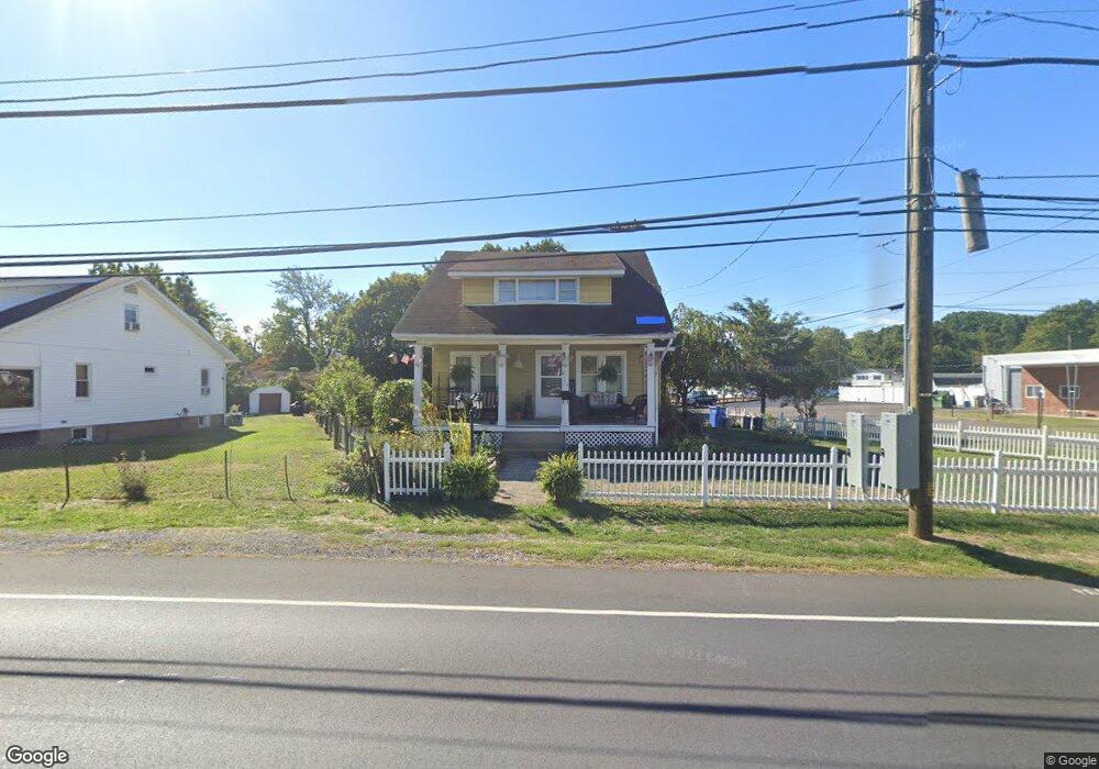
2113 State Rd Bensalem, PA 19020
Estimated Value: $339,909 - $410,000
3
Beds
1
Bath
1,635
Sq Ft
$228/Sq Ft
Est. Value
About This Home
This home is located at 2113 State Rd, Bensalem, PA 19020 and is currently estimated at $372,227, approximately $227 per square foot. 2113 State Rd is a home located in Bucks County with nearby schools including Robert K. Shafer Middle School, School Lane Charter School, and St Charles Borromeo School.
Ownership History
Date
Name
Owned For
Owner Type
Purchase Details
Closed on
Aug 26, 1997
Sold by
Fogarty Kathryn M and Barford James D
Bought by
Barford James D and Barford Diane M
Current Estimated Value
Home Financials for this Owner
Home Financials are based on the most recent Mortgage that was taken out on this home.
Original Mortgage
$48,000
Outstanding Balance
$7,367
Interest Rate
7.36%
Estimated Equity
$364,860
Purchase Details
Closed on
Nov 1, 1966
Bought by
Barford Harry B and Barford Catherine M
Create a Home Valuation Report for This Property
The Home Valuation Report is an in-depth analysis detailing your home's value as well as a comparison with similar homes in the area
Home Values in the Area
Average Home Value in this Area
Purchase History
| Date | Buyer | Sale Price | Title Company |
|---|---|---|---|
| Barford James D | $85,000 | -- | |
| Barford Harry B | -- | -- |
Source: Public Records
Mortgage History
| Date | Status | Borrower | Loan Amount |
|---|---|---|---|
| Open | Barford James D | $48,000 |
Source: Public Records
Tax History Compared to Growth
Tax History
| Year | Tax Paid | Tax Assessment Tax Assessment Total Assessment is a certain percentage of the fair market value that is determined by local assessors to be the total taxable value of land and additions on the property. | Land | Improvement |
|---|---|---|---|---|
| 2025 | $2,882 | $13,200 | $3,560 | $9,640 |
| 2024 | $2,882 | $13,200 | $3,560 | $9,640 |
| 2023 | $2,800 | $13,200 | $3,560 | $9,640 |
| 2022 | $2,784 | $13,200 | $3,560 | $9,640 |
| 2021 | $2,784 | $13,200 | $3,560 | $9,640 |
| 2020 | $2,756 | $13,200 | $3,560 | $9,640 |
| 2019 | $2,694 | $13,200 | $3,560 | $9,640 |
| 2018 | $2,632 | $13,200 | $3,560 | $9,640 |
| 2017 | $2,615 | $13,200 | $3,560 | $9,640 |
| 2016 | $2,615 | $13,200 | $3,560 | $9,640 |
| 2015 | -- | $13,200 | $3,560 | $9,640 |
| 2014 | -- | $13,200 | $3,560 | $9,640 |
Source: Public Records
Map
Nearby Homes
- 2025 State Rd
- 126B Royal Mews
- 106 Dock St
- 113 Royal Mews
- 106A Prince George St Unit A
- 120B Dock St
- 136b Alexandria St
- 116B King St
- 97 Waterside Mews
- 114B King St
- 104B King St
- 204A Dock St
- 833 Simons Ave
- 7 Fox Ct Unit EE7
- 2209 Dungan Ave
- 943 Cornwells Ave
- 44 River Ln Unit HH44
- 10 Fawn Ct Unit Z10
- 2 Teal Ct Unit X2
- 1032 Sunset Ln
- 2123 State Rd
- 315 Hemlock Ave
- 2131 State Rd
- 0 State Rd Unit PABU464634
- 0 State Rd Unit PABU464524
- 2102 State Rd
- 2137 State Rd
- 309 Hemlock Ave
- 312 Hemlock Ave
- 2134 State Rd
- 320 Wallace Ave
- 301 Hemlock Ave
- 252 Hemlock Ave
- 318 Wallace Ave
- 257 Cambria Ave
- 428 Wallace Ave
- 247 Hemlock Ave
- 335 Wallace Ave
- 423 Hemlock Ave
- 243 Hemlock Ave