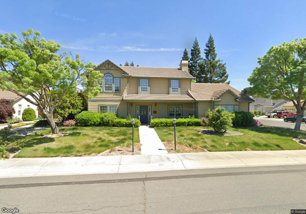
2117 Perry St Sutter, CA 95982
Estimated Value: $600,206 - $786,000
4
Beds
3
Baths
2,331
Sq Ft
$292/Sq Ft
Est. Value
About This Home
This home is located at 2117 Perry St, Sutter, CA 95982 and is currently estimated at $680,802, approximately $292 per square foot. 2117 Perry St is a home located in Sutter County with nearby schools including Brittan Elementary School and Sutter High School.
Ownership History
Date
Name
Owned For
Owner Type
Purchase Details
Closed on
Jan 24, 2017
Sold by
Thomas William Darrin and Thomas Heather S
Bought by
Thomas William Darrin and Thomas Heather Suzanne
Current Estimated Value
Create a Home Valuation Report for This Property
The Home Valuation Report is an in-depth analysis detailing your home's value as well as a comparison with similar homes in the area
Home Values in the Area
Average Home Value in this Area
Purchase History
| Date | Buyer | Sale Price | Title Company |
|---|---|---|---|
| Thomas William Darrin | -- | None Available |
Source: Public Records
Tax History
| Year | Tax Paid | Tax Assessment Tax Assessment Total Assessment is a certain percentage of the fair market value that is determined by local assessors to be the total taxable value of land and additions on the property. | Land | Improvement |
|---|---|---|---|---|
| 2025 | $3,908 | $365,777 | $76,838 | $288,939 |
| 2024 | $3,908 | $358,606 | $75,332 | $283,274 |
| 2023 | $3,908 | $351,575 | $73,855 | $277,720 |
| 2022 | $3,790 | $344,682 | $72,407 | $272,275 |
| 2021 | $3,756 | $337,946 | $70,997 | $266,949 |
| 2020 | $3,708 | $334,480 | $70,269 | $264,211 |
| 2019 | $3,598 | $327,921 | $68,891 | $259,030 |
| 2018 | $3,562 | $321,490 | $67,540 | $253,950 |
| 2017 | $3,363 | $315,186 | $66,216 | $248,970 |
| 2016 | $3,338 | $309,005 | $64,917 | $244,088 |
Source: Public Records
Map
Nearby Homes
- 2185 Perry St
- 2211 W Ridge Dr
- 2227 W Ridge Dr
- 1939 1st Ave
- 8617 S Butte Rd
- 7669 Barrow St
- 2371 Elm St
- 2431 Madrone St
- 1244 Acacia Ave
- 8970 S Butte Rd
- 8454 Pass Rd
- 5576 S Butte Rd
- 2065 Howlett Ave
- 4423 Dresser Rd
- 4361 Dresser Rd
- 1270 Tulio St
- 1803 Lynchburg Dr
- 3295 Jefferson Ave
- 3327 Sam Brannan Way
- 620 Lyndsey Ln
- 2117 Perry St Unit 4
- 2135 Perry St
- 8095 Blue Oak Ct
- 8118 Blue Oak Ct
- 2163 Perry St
- 8110 Blue Oak Ct
- 8063 Blue Oak Ct
- 8055 Blue Oak Ct
- 2065 Perry St
- 8090 Blue Oak Ct
- 8074 Blue Oak Ct
- 8050 Blue Oak Ct
- 8066 Blue Oak Ct
- 2207 W Ridge Dr
- 8082 Blue Oak Ct
- 2219 W Ridge Dr
- 8058 Blue Oak Ct
- 2223 W Ridge Dr
- 0 Perry St
- 1215 Perry St
Your Personal Tour Guide
Ask me questions while you tour the home.