Estimated Value: $359,000 - $394,000
3
Beds
2
Baths
1,210
Sq Ft
$312/Sq Ft
Est. Value
About This Home
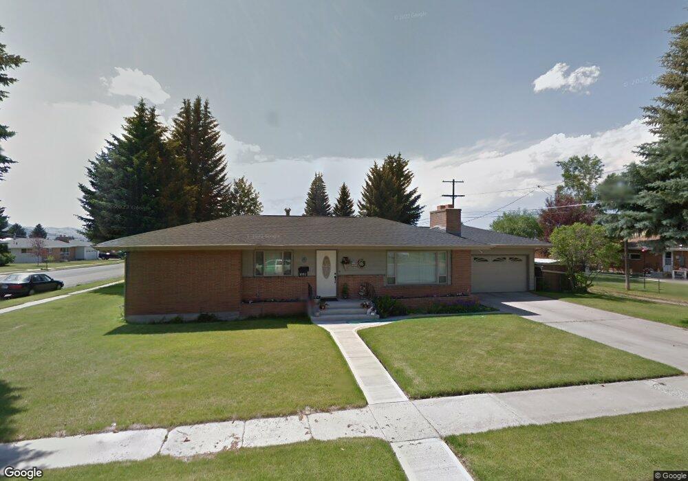
This home is located at 2121 Sheridan Ave, Butte, MT 59701 and is currently estimated at $377,685, approximately $312 per square foot. 2121 Sheridan Ave is a home located in Silver Bow County with nearby schools including Whittier School, East Middle School, and Butte High School.
Ownership History
Date
Name
Owned For
Owner Type
Purchase Details
Closed on
Mar 29, 2024
Sold by
Mengon Patrick
Bought by
Mengon Patrick and Mengon Susan Colleen
Current Estimated Value
Purchase Details
Closed on
May 20, 2009
Sold by
Neil John P O and Neil Cathy L O
Bought by
Mengon Patrick
Home Financials for this Owner
Home Financials are based on the most recent Mortgage that was taken out on this home.
Original Mortgage
$171,429
Interest Rate
0.15%
Create a Home Valuation Report for This Property
The Home Valuation Report is an in-depth analysis detailing your home's value as well as a comparison with similar homes in the area
Home Values in the Area
Average Home Value in this Area
Purchase History
| Date | Buyer | Sale Price | Title Company |
|---|---|---|---|
| Mengon Patrick | -- | None Listed On Document | |
| Mengon Patrick | -- | -- |
Source: Public Records
Mortgage History
| Date | Status | Borrower | Loan Amount |
|---|---|---|---|
| Previous Owner | Mengon Patrick | $171,429 |
Source: Public Records
Tax History Compared to Growth
Tax History
| Year | Tax Paid | Tax Assessment Tax Assessment Total Assessment is a certain percentage of the fair market value that is determined by local assessors to be the total taxable value of land and additions on the property. | Land | Improvement |
|---|---|---|---|---|
| 2025 | $2,632 | $362,300 | $0 | $0 |
| 2024 | $3,339 | $325,900 | $0 | $0 |
| 2023 | $3,407 | $325,900 | $0 | $0 |
| 2022 | $2,951 | $224,500 | $0 | $0 |
| 2021 | $2,487 | $224,500 | $0 | $0 |
| 2020 | $2,608 | $176,700 | $0 | $0 |
| 2019 | $2,615 | $176,700 | $0 | $0 |
| 2018 | $2,595 | $181,000 | $0 | $0 |
| 2017 | $1,836 | $181,000 | $0 | $0 |
| 2016 | $2,284 | $165,900 | $0 | $0 |
| 2015 | $1,750 | $165,900 | $0 | $0 |
| 2014 | $2,161 | $84,270 | $0 | $0 |
Source: Public Records
Map
Nearby Homes
- 2945 Amherst Ave
- 2565 St Ann St
- 2925 Bayard St
- 1906 Sherman Ave
- 2809 State St
- 3120 State St
- 2821 Edwards St
- 2320 South Dr
- 2319 Princeton St
- 2725 Edwards St
- 3127 Edwards St
- 2922 E Edwards
- 2922 Edwards St
- 2245 South Dr
- 3101 Phillips St
- 2219 Amherst Ave
- 2263 West Dr
- 2212 Massachusetts Ave
- 2318 Argyle St
- 1801 Yale Ave
- 2925 Nettie St
- 2930 Moulton St
- 2920 Moulton St
- 2930 Nettie St
- 2915 Nettie St
- 2920 Nettie St
- 3000 Moulton St
- 2310 Sheridan Ave
- 3005 Nettie St
- 2910 Moulton St
- 2910 Nettie St
- 3010 Nettie St
- 3010 Moulton St
- 2905 Nettie St
- 2935 Moulton St
- 2919 Ottawa St
- 2917 Ottawa St
- 3015 Nettie St
- 2900 Moulton St
- 2925 Moulton St