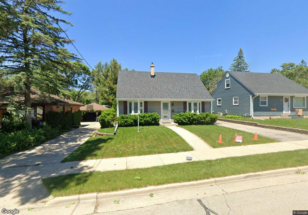
2126 Sunkist Ave Waukesha, WI 53188
Estimated Value: $333,000 - $382,000
4
Beds
2
Baths
1,940
Sq Ft
$182/Sq Ft
Est. Value
About This Home
This home is located at 2126 Sunkist Ave, Waukesha, WI 53188 and is currently estimated at $353,252, approximately $182 per square foot. 2126 Sunkist Ave is a home located in Waukesha County with nearby schools including Summit View Elementary School, Butler Middle School, and North High School.
Ownership History
Date
Name
Owned For
Owner Type
Purchase Details
Closed on
Mar 29, 2013
Sold by
Haessig Lee R and Haessig Laura J
Bought by
Turdo Michael G and Turdo Kristy A
Current Estimated Value
Home Financials for this Owner
Home Financials are based on the most recent Mortgage that was taken out on this home.
Original Mortgage
$163,400
Outstanding Balance
$115,599
Interest Rate
3.52%
Mortgage Type
New Conventional
Estimated Equity
$237,653
Create a Home Valuation Report for This Property
The Home Valuation Report is an in-depth analysis detailing your home's value as well as a comparison with similar homes in the area
Home Values in the Area
Average Home Value in this Area
Purchase History
| Date | Buyer | Sale Price | Title Company |
|---|---|---|---|
| Turdo Michael G | $172,000 | None Available |
Source: Public Records
Mortgage History
| Date | Status | Borrower | Loan Amount |
|---|---|---|---|
| Open | Turdo Michael G | $163,400 |
Source: Public Records
Tax History Compared to Growth
Tax History
| Year | Tax Paid | Tax Assessment Tax Assessment Total Assessment is a certain percentage of the fair market value that is determined by local assessors to be the total taxable value of land and additions on the property. | Land | Improvement |
|---|---|---|---|---|
| 2024 | $3,851 | $252,100 | $51,000 | $201,100 |
| 2023 | $3,578 | $252,100 | $51,000 | $201,100 |
| 2022 | $3,766 | $198,500 | $56,100 | $142,400 |
| 2021 | $3,849 | $198,500 | $56,100 | $142,400 |
| 2020 | $3,728 | $198,500 | $56,100 | $142,400 |
| 2019 | $3,607 | $198,500 | $56,100 | $142,400 |
| 2018 | $3,312 | $178,800 | $45,900 | $132,900 |
| 2017 | $3,310 | $178,800 | $45,900 | $132,900 |
| 2016 | $3,428 | $173,600 | $42,800 | $130,800 |
| 2015 | $3,409 | $173,600 | $42,800 | $130,800 |
| 2014 | $3,379 | $165,300 | $42,800 | $122,500 |
| 2013 | $3,379 | $165,300 | $42,800 | $122,500 |
Source: Public Records
Map
Nearby Homes
- 2012 Sunkist Ave
- 1606 Pleasant View Ave
- 1513 N Bel Ayr Dr
- 2145 Broken Hill Rd Unit 5
- 704 Western Ave
- 2207 Norwood Dr
- 2300 Norwood Dr
- 630 Westowne Ave
- 1911 Woodburn Rd Unit C
- 608 N Grandview Blvd
- 2013 Woodburn Rd Unit A
- 2740 Northview Rd Unit 102
- 2732 Northview Rd Unit 88
- 2740 Northview Rd
- 2728 Northview Rd
- 2728 Northview Rd Unit 61
- 1917 Tree Line Ct
- 610 Glendon Way
- 2605 Emslie Dr
- 2116 Woodburn Rd Unit B
- 2120 Sunkist Ave
- 2204 Sunkist Ave
- 2112 Sunkist Ave
- 1707 Patricia Ln
- 2208 Sunkist Ave
- 1703 Patricia Ln
- 2130 Sunkist Ave
- 2203 Sunkist Ave
- 2104 Sunkist Ave
- 2127 Sunkist Ave
- 1704 Patricia Ln
- 2121 Sunkist Ave
- 2131 Sunkist Ave
- 2115 Sunkist Ave
- 1801 Patricia Ln
- 2212 Sunkist Ave
- 2107 Sunkist Ave
- 1711 Patricia Ln
- 1717 Patricia Ln
- 1807 Patricia Ln