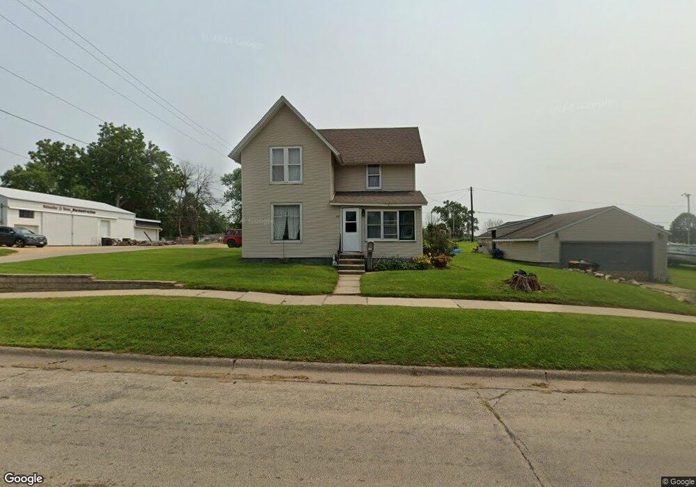
213 N Walnut St Maquoketa, IA 52060
Estimated Value: $130,000 - $153,000
3
Beds
1
Bath
1,144
Sq Ft
$124/Sq Ft
Est. Value
About This Home
This home is located at 213 N Walnut St, Maquoketa, IA 52060 and is currently estimated at $141,361, approximately $123 per square foot. 213 N Walnut St is a home located in Jackson County with nearby schools including Cardinal Elementary School, Briggs Elementary School, and Maquoketa Middle School.
Ownership History
Date
Name
Owned For
Owner Type
Purchase Details
Closed on
Jul 1, 2008
Sold by
Petrillo Tamela J and Petrillo Adolph D
Bought by
Breitbach Daniel A and Breitbach Karen L
Current Estimated Value
Home Financials for this Owner
Home Financials are based on the most recent Mortgage that was taken out on this home.
Original Mortgage
$56,000
Outstanding Balance
$35,935
Interest Rate
6.05%
Mortgage Type
Future Advance Clause Open End Mortgage
Estimated Equity
$105,426
Create a Home Valuation Report for This Property
The Home Valuation Report is an in-depth analysis detailing your home's value as well as a comparison with similar homes in the area
Home Values in the Area
Average Home Value in this Area
Purchase History
| Date | Buyer | Sale Price | Title Company |
|---|---|---|---|
| Breitbach Daniel A | $70,000 | None Available |
Source: Public Records
Mortgage History
| Date | Status | Borrower | Loan Amount |
|---|---|---|---|
| Open | Breitbach Daniel A | $56,000 |
Source: Public Records
Tax History Compared to Growth
Tax History
| Year | Tax Paid | Tax Assessment Tax Assessment Total Assessment is a certain percentage of the fair market value that is determined by local assessors to be the total taxable value of land and additions on the property. | Land | Improvement |
|---|---|---|---|---|
| 2025 | $1,780 | $120,300 | $16,400 | $103,900 |
| 2024 | $1,780 | $112,200 | $12,300 | $99,900 |
| 2023 | $1,746 | $112,200 | $12,300 | $99,900 |
| 2022 | $1,350 | $72,100 | $12,300 | $59,800 |
| 2021 | $1,486 | $72,100 | $12,300 | $59,800 |
| 2020 | $1,486 | $76,500 | $12,300 | $64,200 |
| 2019 | $1,478 | $76,500 | $0 | $0 |
| 2018 | $1,404 | $76,500 | $0 | $0 |
| 2017 | $1,404 | $79,300 | $0 | $0 |
| 2016 | $1,452 | $79,300 | $0 | $0 |
| 2015 | $1,452 | $79,300 | $0 | $0 |
| 2014 | $1,474 | $79,300 | $0 | $0 |
Source: Public Records
Map
Nearby Homes
- 310 N Dearborn St
- 911 Lisa Dr
- 124 E Platt St
- 318 N Main St
- 302 E Maple St
- 202 W Apple St
- 0 Hurstville Rd
- 210 S 2nd St
- 313 S 4th St
- 407 S Niagara St
- 707 W Platt St
- 712 S 2nd St
- 1005 German St
- 108 W Monroe St
- 401-435 Forest Dr
- 401-435 Forest Dr Unit Meadow Park Subdivis
- 309 Rosemere Ln
- 413 Rosemere Ln
- Lot 2 Timber Dr
- Lot 3 Timber Dr
- 209 N Walnut St
- 301 N Walnut St
- 305 N Walnut St
- 210 N Walnut St
- 212 N Walnut St
- 205 N Walnut St
- 307 N Walnut St
- 208 N Walnut St
- 302 N Walnut St
- 701 E Apple St
- 203 N Walnut St
- 308 N Walnut St
- 209 N Dearborn St
- 211 N Dearborn St
- 311 N Walnut St
- 204 N Walnut St
- 201 N Walnut St
- 207 N Dearborn St
- 310 N Walnut St
- 907 Kathey Dr