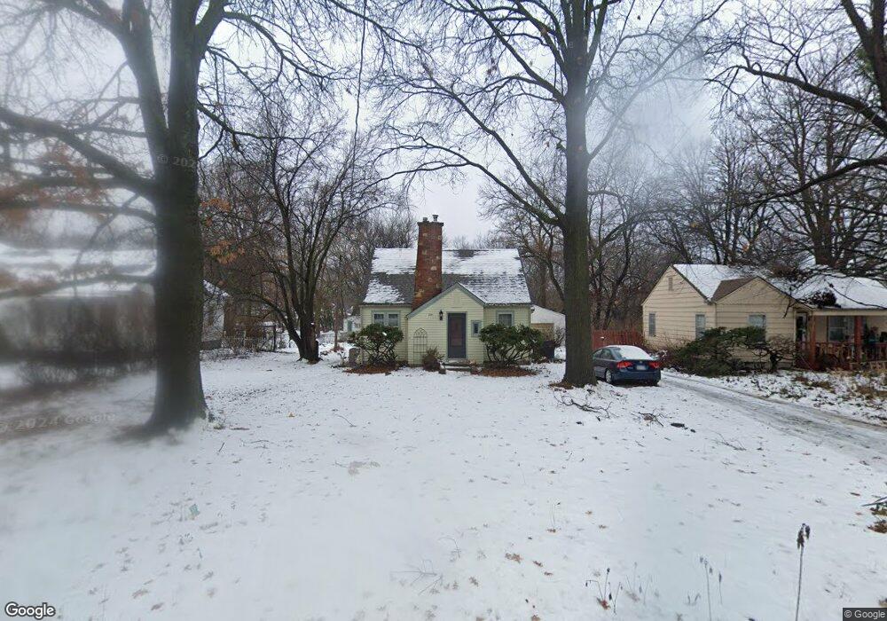
2141 Learnard Ave Lawrence, KS 66046
Barker NeighborhoodEstimated Value: $260,000 - $273,000
2
Beds
1
Bath
1,084
Sq Ft
$245/Sq Ft
Est. Value
About This Home
This home is located at 2141 Learnard Ave, Lawrence, KS 66046 and is currently estimated at $266,088, approximately $245 per square foot. 2141 Learnard Ave is a home located in Douglas County with nearby schools including Kennedy Elementary School, Liberty Memorial Central Middle School, and Lawrence High School.
Ownership History
Date
Name
Owned For
Owner Type
Purchase Details
Closed on
Nov 8, 2009
Sold by
Longhurst John David Thomas and Longhurst Angela
Bought by
Poell Nathan D and Phelps Megan E
Current Estimated Value
Home Financials for this Owner
Home Financials are based on the most recent Mortgage that was taken out on this home.
Original Mortgage
$80,000
Interest Rate
4.93%
Mortgage Type
New Conventional
Create a Home Valuation Report for This Property
The Home Valuation Report is an in-depth analysis detailing your home's value as well as a comparison with similar homes in the area
Home Values in the Area
Average Home Value in this Area
Purchase History
| Date | Buyer | Sale Price | Title Company |
|---|---|---|---|
| Poell Nathan D | -- | Capital Title Ins Company Lc |
Source: Public Records
Mortgage History
| Date | Status | Borrower | Loan Amount |
|---|---|---|---|
| Closed | Poell Nathan D | $80,000 |
Source: Public Records
Tax History Compared to Growth
Tax History
| Year | Tax Paid | Tax Assessment Tax Assessment Total Assessment is a certain percentage of the fair market value that is determined by local assessors to be the total taxable value of land and additions on the property. | Land | Improvement |
|---|---|---|---|---|
| 2025 | $3,891 | $31,694 | $9,200 | $22,494 |
| 2024 | $3,713 | $30,280 | $8,625 | $21,655 |
| 2023 | $3,458 | $27,106 | $6,900 | $20,206 |
| 2022 | $3,172 | $24,725 | $6,325 | $18,400 |
| 2021 | $2,792 | $21,011 | $5,175 | $15,836 |
| 2020 | $2,757 | $20,861 | $5,175 | $15,686 |
| 2019 | $2,659 | $20,148 | $4,947 | $15,201 |
| 2018 | $2,476 | $18,653 | $4,720 | $13,933 |
| 2017 | $2,414 | $17,986 | $4,720 | $13,266 |
| 2016 | $2,198 | $17,135 | $4,884 | $12,251 |
| 2015 | $1,062 | $16,571 | $6,104 | $10,467 |
| 2014 | $1,052 | $16,571 | $6,104 | $10,467 |
Source: Public Records
Map
Nearby Homes
- 2028 New Hampshire St
- 2045 Massachusetts St
- 2301 Massachusetts St
- 331 E 19th St
- 2116 Kentucky St
- 2046 Kentucky St
- 5701 Johnson Ave
- 314 Oklahoma St
- 1625 Pennsylvania St
- 1103 E 18th St
- 1829 Brook St
- 1221 E 25th St
- 2014 Maple Ln
- 1736 Brook St
- 923 Ward Ave
- 1424 New York St
- 1711 E 21st Terrace
- 1616 Louisiana St
- 1729 Mississippi St
- 0 Delaware St
- 2139 Learnard Ave
- 2201 Learnard Ave
- 2145 Learnard Ave
- 2131 Learnard Ave
- 2125 Learnard Ave
- 2138 Learnard Ave
- 2205 Learnard Ave
- 2136 Learnard Ave
- 2134 Learnard Ave
- 2115 Learnard Ave
- 2211 Learnard Ave
- 2139 Pennsylvania St
- 2208 Learnard Ave
- 2132 Learnard Ave
- 2203 Pennsylvania St
- 2130 Learnard Ave
- 2214 Learnard Ave
- 2111 Learnard Ave
- 2221 Learnard Ave
- 2209 Pennsylvania St